Ashfield, Argyll and Bute

Last updated

Ashfield
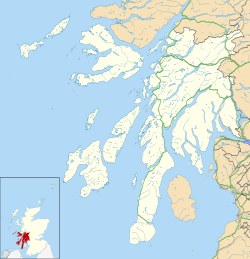
Argyll and Bute UK location map.svg
Red pog.svg
Ashfield
Location within Argyll and Bute
OS grid reference NR765854
Council area
Country Scotland
Sovereign state United Kingdom
Police Scotland
Fire Scottish
Ambulance Scottish
List of places
UK
Scotland
56°00′36″N5°35′10″W / 56.010°N 05.586°W / 56.010; -05.586 Coordinates: 56°00′36″N5°35′10″W / 56.010°N 05.586°W / 56.010; -05.586

Ashfield is a village in the civil parish of North Knapdale, in Knapdale, in the council area of Argyll and Bute, Scotland. It has a sheep farm and cottage and once had a school. [1] [2]
History

The name "Ashfield" is Gaelic and means "the ash slope". [3]

Related Research Articles

River Tay Longest river in Scotland

The River Tay is the longest river in Scotland and the seventh-longest in Great Britain. The Tay originates in western Scotland on the slopes of Ben Lui, then flows easterly across the Highlands, through Loch Dochart, Loch Iubhair and Loch Tay, then continues east through Strathtay, in the centre of Scotland, then southeasterly through Perth, where it becomes tidal, to its mouth at the Firth of Tay, south of Dundee. It is the largest river in the British Isles by measured discharge. Its catchment is approximately 2,000 square miles (5,200 km2), the Tweed's is 1,500 square miles (3,900 km2) and the Spey's is 1,097 square miles (2,840 km2).

Argyll Historic county in Scotland

Argyll, sometimes called Argyllshire, is a historic county and registration county of western Scotland.

Kintyre Peninsula in Argyll and Bute, Scotland, UK

Kintyre is a peninsula in western Scotland, in the southwest of Argyll and Bute. The peninsula stretches about 30 miles, from the Mull of Kintyre in the south to East and West Loch Tarbert in the north. The region immediately north of Kintyre is known as Knapdale.

Gigha Island in Scotland

Gigha or the Isle of Gigha is an island off the west coast of Kintyre in Scotland. The island forms part of Argyll and Bute and has a population of 163 people. The climate is mild with higher than average sunshine hours and the soils are fertile. The main settlement is Ardminish.

Knapdale Human settlement in Scotland

Knapdale forms a rural district of Argyll and Bute in the Scottish Highlands, adjoining Kintyre to the south, and divided from the rest of Argyll to the north by the Crinan Canal. It includes two parishes, North Knapdale and South Knapdale. The area is bounded by sea to the east and west, whilst the sea loch of West Loch Tarbert almost completely cuts off the area from Kintyre to the south. The name is derived from two Gaelic elements: Cnap meaning hill and Dall meaning field.

Ardrishaig Human settlement in Scotland

Ardrishaig is a coastal village on Loch Gilp, at the southern (eastern) entrance to the Crinan Canal in Argyll and Bute in the west of Scotland. It lies immediately to the south of Lochgilphead, with the nearest larger town being Oban.

Eurasian beaver Species of beaver

The Eurasian beaver or European beaver is a beaver species that was once widespread in Eurasia, but was hunted to near-extinction for both its fur and castoreum. At the turn of the 20th century, only about 1,200 beavers survived in eight relict populations in Europe and Asia. It has been reintroduced to much of its former range, and now occurs from Spain, Central Europe, Great Britain and Scandinavia to a few regions in China and Mongolia. It is listed as least concern on the IUCN Red List, as it recovered well in most of Europe. It is extirpated in Portugal, Moldova, and Turkey.

Achahoish

Achahoish is a village on the west coast of Knapdale in the Scottish council area of Argyll and Bute. In 1882, Wilson's The Gazetter of Scotland described Achahoish as a "...hamlet at the head of Loch Killisport. It has a post office...".

Achnamara

Achnamara is a village in the Scottish council area of Argyll and Bute. Its location is approximately 56°1' N 5°34' W. Achnamara means 'field by the sea'. The name is formed from the Gaelic words achadh 'field', the definite article an, and muir 'sea'.

Ormsary is a hamlet in Knapdale, Argyll and Bute, Scotland.

Castle Sween 11th century castle in Scotland

Castle Sween, also known as Caisteal Suibhne, and Caistéal Suibhne, is located on the eastern shore of Loch Sween, in Knapdale, south of the forestry village of Achnamara on the west coast of Argyll, Scotland. Castle Sween is thought to be one of the earliest stone castles built in Scotland, having been built in the late 11th century. The castle's towers were later additions to wooden structures which have since vanished.

Ashfield, Stirling Human settlement in Scotland

Ashfield is a hamlet in the Registration county of Perth and the local government district of Stirling, Scotland. It lies between the Allan Water and the Stirling-Perth Railway line. It is two miles north of Dunblane, and was designated a conservation village in 1976. It was originally built to house workers at a nearby silk-dyeing mill. Prior to this, a mill, Millash or Mill of Ash, existed, as did an extensive house or farm. Ashfield has four residential streets, a residential block and also a square, named after the former prime minister William Gladstone, called Gladstone Square.

The parish of Kilcalmonell is situated in Argyll and Bute, Scotland. It extends from Clachan, in Kintyre to Kilberry, in Knapdale.

Eilean dà Mhèinn

Eilean dà Mhèinn, is a small inhabited island in Loch Crinan and one of the Inner Hebrides of Scotland.

Eilean Mòr, MacCormaig Isles

Eilean Mòr is one of the MacCormaig Isles situated near the entrance to Loch Sween in the Sound of Jura, Argyll and Bute, Scotland. Eilean Mòr is uninhabited.

Taynish National Nature Reserve

Taynish National Nature Reserve is situated southwest of the village of Tayvallich in the council area of Argyll and Bute on the west coast of Scotland. The reserve encompasses almost all of the Taynish peninsula, which is around 5 km long and 1 km wide. The woodlands at Taynish are often described as a 'temperate rainforest', benefiting from the mild and moist climate brought about by the Gulf Stream. Taynish is owned and managed by NatureScot and was declared a national nature reserve (NNR) in 1977. The reserve was formerly also a biosphere reserve, but this status was withdrawn in 2014.

Lagg, Jura Human settlement in Scotland

Lagg is a hamlet on Lagg Bay, on the east coast of the island of Jura, in the council area of Argyll and Bute, Scotland. It is on the A846 8 miles (13 km) from Craighouse. Lagg consists of two main areas, Lagg township, above a steep slope from the bay, away from the coastal edge. The former inn is the other. Dunchraobhan is at a similar elevation to Lagg.

Barmore Island Peninsula in Scotland

Barmore Island is a peninsula in Scotland located on the east of Knapdale, in the council area of Argyll and Bute. It is 1 and a half miles north from Tarbert.

References

  1. "Ashfield". Gazetteer for Scotland . Retrieved 18 March 2021.
  2. "Descriptive gazetteer entry for Ashfield". A Vision of Britain through Time . Retrieved 18 March 2021.
  3. "Placenames A-B" (PDF). Scottish Parliament. Archived from the original (PDF) on 18 December 2020. Retrieved 18 March 2021.