The Santa Monica Mountains is a coastal mountain range in Southern California, paralleling the Pacific Ocean. It is part of the Transverse Ranges. Because of its proximity to densely populated regions, it is one of the most visited natural areas in California. Santa Monica Mountains National Recreation Area is located in this mountain range.

Cascade Mountain is in Essex County of New York. It is one of the 46 Adirondack High Peaks (36th) and is located in the Adirondack Park. Its name comes from a series of waterfalls on a brook near the mountain's base. The lake it flows into and the pass between Cascade and Pitchoff mountains are also named Cascade.
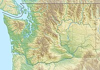
The Mummy Range is a mountain range in the Rocky Mountains of northern Colorado in the United States. The range is a short subrange of the Front Range located in southwestern Larimer County northwest of the town of Estes Park. It is located largely within Rocky Mountain National Park, extending north from Trail Ridge Road approximately 15 miles (24 km).

Red Mountain is a set of three peaks in the San Juan Mountains of western Colorado in the United States, about 5 miles south of Ouray. The mountains get their name from the reddish iron ore rocks that cover the surface. Several other peaks in the San Juan Mountains likewise have prominent reddish coloration from iron ore and are also called "Red Mountain".

Mount Ouray is a high and prominent mountain summit in the far southern Sawatch Range of the Rocky Mountains of North America. The 13,961-foot (4255.4 m) thirteener is located in San Isabel National Forest, 7.5 miles (12.0 km) west of Poncha Pass, Colorado, United States, on the boundary between Chaffee and Saguache counties. The mountain was named in honor of Ute Chief Ouray.
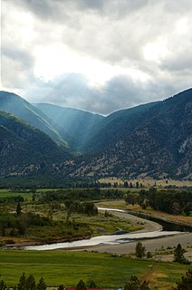
The Similkameen River runs through southern British Columbia, Canada, eventually discharging into the Okanagan River near Oroville, Washington, in the United States. The river is about 197 km (122 mi) long, with a drainage basin area of 7,600 km2 (2,900 sq mi). The river is said to be named for an indigenous people called <Similkameigh>, meaning "treacherous waters".

Cathedral Provincial Park and Protected Area, usually known as Cathedral Provincial Park and also as Cathedral Park, is a provincial park in British Columbia, Canada. It is located east of E.C. Manning Provincial Park, south of BC Highway 3, and southeast of the town of Princeton and southwest of Keremeos. Its southern boundary is the border with the United States. Much of the park is the basin of the Ashnola River.

Mount Colden is the eleventh-highest peak in the High Peaks of the Adirondack Mountains, New York, United States. The peak was named after David S. Colden, an investor in the McIntyre Iron Works, in 1836. The peak was briefly renamed "Mount McMartin" the next year, but the older name persisted. The mountain is known for its distinctive Trap Dike, a large crevice running up the center of the mountain, which can clearly be seen from Avalanche Lake.
The Lower Similkameen Indian Band or Lower Smelqmix, is a First Nations band government in the Canadian province of British Columbia. Their office is located in the village of Keremeos in the Similkameen region. They are a member of the Okanagan Nation Alliance.

Seymour Mountain is a mountain located in Franklin County, New York, named after Horatio Seymour (1810–1886), Governor of New York. The mountain is part of the Seward Mountains of the Adirondacks. Seymour Mountain faces Seward Mountain to the west across Ouluska Pass.

The Okanagan Range or Okanogan Range is a small subrange of the Cascade Range straddling the border between British Columbia and Washington south of the Similkameen River on the inland side of the range. The range is the northeasternmost extremity of the Cascade Range.

The MacIntyre Mountains or MacIntyre Range is a range of mountains in the High Peaks region of the Adirondacks, due west of Mount Marcy, in northeastern New York State. The range runs 8 miles (13 km) from southwest to northeast. Its sheer southwest slope makes up one side of Indian Pass, and a northeastern spur forms the cliffs of Avalanche Pass.

Wallface Mountain is a mountain located in Essex County, New York. The mountain is named after the cliff on its southeastern side. Wallface is flanked to the west by MacNaughton Mountain, and faces Mount Marshall to the southeast across Indian Pass.

The Ashnola River is a tributary of the Similkameen River, rising in the northeastern part of the North Cascades in Washington, United States, and flowing north into British Columbia, Canada, to join the Similkameen River about halfway along that river's course between the towns of Princeton and Keremeos. The river crosses the international boundary at 49°00′00″N120°19′37″W and transits Cathedral Provincial Park. It has one main tributary, Ewart Creek, which is about 25 kilometres (16 mi) long and begins virtually at the border and is entirely within Cathedral Park.
Ashnola is an Okanagan language word of unknown meaning and which is Acnulox in the modern spelling system of that language. It may refer to:

The Indian Pass Wilderness is 32,418-acre (13,119 ha) wilderness area under the administered by the Bureau of Land Management. The reserve is located in the very southeastern part of the Chocolate Mountains, in the southeastern part of California, just to the west of the Colorado River in the Lower Colorado River Valley. It adjoins the Picacho Peak Wilderness to the south, and the Imperial National Wildlife Refuge to the east.

The Sunset Mountains in Coconino County, Arizona are two a small mesas known as East Sunset Mountain and West Sunset Mountain, located southeast of Winslow. State Route 87 passes between the mountains.

Terrace Mountain is a mountain peak in the Gallatin Range in Yellowstone National Park, Wyoming, United States. The mountain is located 2.2 miles (3.5 km) southwest of Mammoth Hot Springs. Terrace Mountain was named by the 1878 Hayden Geological Survey because of its proximity to the travertine terraces at Mammoth and because it too is an ancient travertine terrace. The mountain has also been known as "Soda Mountain" and "White Mountain".
Ashnola is a locality and former railway point in the Similkameen Country of southern British Columbia, Canada, located at the confluence of the Ashnola River with the Similkameen. Ashnola Indian Reserve No. 10 is at the same general location.