Ashnola River

Last updated
Ashnola River

2017 09 23-18.27.38.216-CDT.jpg

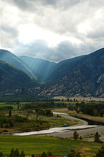
Aerial view of the Ashnola River in 2017
Basin features
Tributaries

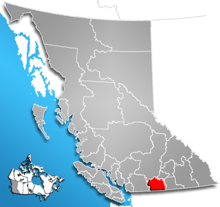
The Ashnola River is a tributary of the Similkameen River, rising in the northeastern part of the North Cascades in Washington, United States, and flowing north into British Columbia, Canada, to join the Similkameen River about halfway along that river's course between the towns of Princeton and Keremeos. The river crosses the international boundary at 49°00′00″N120°19′37″W / 49.00000°N 120.32694°W / 49.00000; -120.32694 and transits Cathedral Provincial Park. It has one main tributary, Ewart Creek, which is about 25 kilometres (16 mi) long and begins virtually at the border and is entirely within Cathedral Park.

Tributary stream or river that flows into a main stem river or lake

A tributary or affluent is a stream or river that flows into a larger stream or main stem river or a lake. A tributary does not flow directly into a sea or ocean. Tributaries and the main stem river drain the surrounding drainage basin of its surface water and groundwater, leading the water out into an ocean.

Similkameen River river

The Similkameen River runs through southern British Columbia, Canada, eventually discharging into the Okanagan River near Oroville, Washington, in the United States. The river is about 197 km (122 mi) long, with a drainage basin area of 7,600 km2 (2,900 sq mi). The river is said to be named for an indigenous people called <Similkameigh>, meaning "treacherous waters".

North Cascades mountains in the U.S. and Canada

The North Cascades are a section of the Cascade Range of western North America. They span the border between the Canadian province of British Columbia and the U.S. state of Washington and are officially named in the U.S. and Canada as the Cascade Mountains. The portion in Canada is known to Americans as the Canadian Cascades, a designation that also includes the mountains above the east bank of the Fraser Canyon as far north as the town of Lytton, at the confluence of the Thompson and Fraser Rivers.

Contents

A gravel road from its junction with BC Highway 3 at the locality of Ashnola flanking the river is the main, and virtually only, road access to the park. The locality of Ashnola was that of a mining camp from the days of the many gold rushes in the Similkameen Country and also the site of the Ashnola Indian Reserve (attached to the Lower Similkameen Indian Band). [1]

Ashnola is a locality and former railway point in the Similkameen Country of southern British Columbia, Canada, located at the confluence of the Ashnola River with the Similkameen. Ashnola Indian Reserve No. 10 is at the same general location.

The Similkameen Country, also referred to as the Similkameen Valley or Similkameen District, but generally referred to simply as The Similkameen or more archaically, Similkameen, is a region roughly coinciding with the basin of the river of the same name in the Southern Interior of British Columbia. The term "Similkameen District" also refers to the Similkameen Mining District, a defunct government administrative district, which geographically encompasses the same area, and in more casual terms may also refer to the Similkameen electoral district, which was combined with the Grand Forks-Greenwood riding by the time of the 1966 election. The Similkameen Country has deep historical connections to the Boundary Country and the two are sometimes considered one region, partly as a result of the name of the electoral district. It is also sometimes classed as being part of the Okanagan region, which results from shared regional district and other administrative boundaries and names. The term "Similkameen District" may also historically refer to the Similkameen Division Yale Land District, which also includes Osoyoos and the Boundary Country to Osoyoos' east.

The Lower Similkameen Indian Band or Lower Smelqmix, is a First Nations band government in the Canadian province of British Columbia. Their office is located in the village of Keremeos in the Similkameen region. They are a member of the Okanagan Nation Alliance.

Name variants and origin

Older name-variants includes Nais-nu-loh and Ashtnolow (both from Lord, 1860), Ashtnoulou (1861), Ashnoulou River, Trutch, 1871. An article in BC Motorist magazine [2] claims that the meaning of Ashnola is "white waters" but other sources say the meaning is unknown. British Columbia Place Names, a semi-authoritative work on the toponymy of British Columbia, says the original form of the name is that of the Indian village formerly at the Ashnola Indian Reserve, which in the modern spelling system of the Okanagan language is rendered Acnulox. [3]

Joseph Trutch politician

Sir Joseph William Trutch, was an English-born Canadian engineer, surveyor and politician.

Okanagan, or Colville-Okanagan, is a Salish language which arose among the indigenous peoples of the southern Interior Plateau region based primarily in the Okanagan River Basin and the Columbia River Basin in precolonial times in Canada and the United States. Following British, American, and Canadian colonization during the 1800s and the subsequent repression of all Salishan languages, the use of Colville-Okanagan declined drastically.

See also

Ashnola Pass

Ashnola Pass is a mountain pass in the North Cascades of northwestern Washington in the Pasayten Wilderness. See Ashnola River for name information.

Ashnola Mountain mountain in United States of America

Ashnola Mountain is a mountain in the Okanagan Range of the North Cascades in Washington state, located near Ashnola Pass and the headwaters of the Ashnola River, which flows north into British Columbia, Canada, to join the Similkameen River.

Related Research Articles

Hedley, British Columbia human settlement in Canada

Hedley is an unincorporated town in southern British Columbia, Canada, named after Robert R. Hedley, the manager of the Hall Smelter in Nelson. Hedley is located at the foot of Nickel Plate Mountain in the Similkameen. The town had a population of approximately 242 as of 2016. In the early 1900s, Hedley's population peaked over 1,000 people, primarily due to the gold mining industry. The Hedley Museum and the Mascot Mine Museum display artifacts and photographs from this era.

Keremeos Village in British Columbia, Canada

Keremeos is a village in the Southern Interior of British Columbia, Canada. The name originated from the Similkameen dialect of the Okanagan language word "Keremeyeus" meaning "creek which cuts its way through the flats" referring to Keremeos Creek which flows down from the Upper Benchlands to the Similkameen River that runs by the village. Local legend claims the name means "the meeting of the winds" and joke that the only time it's calm is when the wind blows equally from all four directions.

Cathedral Provincial Park and Protected Area provincial park in British Columbia, Canada

Cathedral Provincial Park and Protected Area, usually known as Cathedral Provincial Park and also as Cathedral Park, is a provincial park in British Columbia, Canada. It is located east of E.C. Manning Provincial Park, south of BC Highway 3, and southeast of the town of Princeton and southwest of Keremeos. Its southern boundary is the border with the United States. Much of the park is the basin of the Ashnola River.

Coldwater River Provincial Park is a provincial park in British Columbia, Canada, located at the confluence of the Coldwater River with Cullet Creek, 50 km south of Merritt on BC Highway 5.

Prophet River Wayside Provincial Park is a provincial park in British Columbia, Canada. It is located along Prophet River, by the Alaska Highway, between the localities of Trutch and Prophet River. Originally created as a Provincial Recreation Area in 1977 with an area of 707 acres (2.86 km2), it was designated a provincial park in 1999 with an area of 111 hectares.

Regional District of Okanagan-Similkameen regional district in British Columbia

The Regional District of Okanagan-Similkameen (RDOS) is in southern British Columbia, adjacent to the U.S. state of Washington. It is bounded by Fraser Valley Regional District to the west, Thompson-Nicola Regional District and Regional District of Central Okanagan to the north, Regional District of Kootenay Boundary to the east, and by Okanogan County, Washington to the south. At the 2011 census the population was 80,742. The district covers a land area of 10,413.44 square kilometres (4,020.65 sq mi). The administrative offices are in the City of Penticton.

Stemwinder Provincial Park provincial park in British Columbia

Stemwinder Provincial Park is a provincial park located just west of Hedly in British Columbia, Canada. The park is 4 hectares in size, and provides public access to the Similkameen River.

Cawston, British Columbia human settlement in Canada

Cawston is an unincorporated small community in the south Similkameen Valley.

The Upper Similkameen Indian Band or Upper Smelqmix, is a First Nations band government in the Canadian province of British Columbia, whose head offices are located in town of Hedley in the Similkameen Country. They are a member of the Okanagan Nation Alliance.

Canoe Creek Band/Dog Creek Indian Band

The Canoe Creek Band/Dog Creek Indian Band, also known as the Canoe Creek First Nation and/or Dog Creek First Nation is a First Nations government of the Secwepemc (Shuswap) Nation, located in the Fraser Canyon-Cariboo region of the Central Interior of the Canadian province of British Columbia. It was created when the government of the then-Colony of British Columbia established an Indian Reserve system in the 1860s. It is a member government of the Northern Shuswap Tribal Council.

The High Bar First Nation is a First Nations government of the Secwepemc (Shuswap) Nation, located in the Fraser Canyon-Cariboo region of the Central Interior of the Canadian province of British Columbia. It was created when the government of the then-Colony of British Columbia established an Indian Reserve system in the 1860s. It is one of three Secwepemc bands that is not a member of either the Shuswap Nation Tribal Council or the Northern Shuswap Tribal Council. The High Bar people are also partly Tsilhqot'in and have links with some Chilcotin First Nations.

The Tl'etinqox-t'in Government Office is a First Nations government located in the Chilcotin District in the western Central Interior region of the Canadian province of British Columbia. Governing a reserve communities near Alexis Creek known as Anaham Reserve First Nations or Anaham, it is a member of the Tsilhqot'in Tribal Council aka known as the Tsilhqot'in National Government. The main reserve is officially known as Anahim's Flat No. 1, and is more commonly as Anaham. Other reserves are Anahim's Meadow No. 2 and 2A, and Anahim Indian Reserves Nos. 3 through 18. Anaham, or Anahim and Alexis were chiefs of the Tsilhqot'in during the Chilcotin War of 1864, although they and their people did not take part in the hostilities.

The Nazko First Nation is a First Nations government of the Dakelh people in the north-central Interior of British Columbia. Its reserves are located around the community of Nazko, British Columbia, which is 120 km west of Quesnel and southwest of Prince George.

Chopaka is an unincorporated settlement near the US border on the west bank of the Similkameen River in the Southern Interior of British Columbia, Canada. Largely comprising two Indian Reserves, 'Chopaka IR No. 7 and Chopaka IR No. 8, the location was formerly listed as a railway station on the Burlington Northern Railway. There is a border crossing at Chopaka, open daily 9 AM to 5 PM. It is recommended to check with Canadian or US Customs to be sure one can cross the border here..

Richter Pass is a mountain pass to the south of the summit of British Columbia highway 3 between Keremeos (W) and Osoyoos (E), linking the Similkameen Valley with the South Okanagan over the southernmost end of the Thompson Plateau. The pass is traversed by Old Richter Pass Road and is ~650 m (2,130 ft) in elevation though the name is generally used for the route of Highway 3 as well.

References

The BC Geographical Names is a geographic name web service and database for British Columbia, Canada, which is run and maintained by the Base Mapping and Geomatic Services Branch of the Integrated Land Management Bureau. The database contains official names and spellings of towns, mountains, rivers, lakes, and other geographic places. The database often has other useful information, such as the history of geographic names, and their use in history.

Geographic Names Information System geographical database

The Geographic Names Information System (GNIS) is a database that contains name and locative information about more than two million physical and cultural features located throughout the United States of America and its territories. It is a type of gazetteer. GNIS was developed by the United States Geological Survey in cooperation with the United States Board on Geographic Names (BGN) to promote the standardization of feature names.

United States Geological Survey scientific agency of the United States government

The United States Geological Survey is a scientific agency of the United States government. The scientists of the USGS study the landscape of the United States, its natural resources, and the natural hazards that threaten it. The organization has four major science disciplines, concerning biology, geography, geology, and hydrology. The USGS is a fact-finding research organization with no regulatory responsibility.

  1. Living Landscapes website index, British Columbia Provincial Museum, item 14*04 SIMILKAMEEN INDIAN ADMINISTRATION (KEREMEOS), RECORDS EST. CA. 1971
  2. Wild Land of the Ashnola by Jennifer Maynard, BC Motorist magazine July-Aug 1971, p.14
  3. British Columbia Place Names, Akrigg, Helen B. and Akrigg, G.P.V, Sono Nis Press, Victoria 1986 /or University of British Columbia Press 1997.

Coordinates: 49°13′00″N119°58′00″W / 49.21667°N 119.96667°W / 49.21667; -119.96667

Geographic coordinate system Coordinate system

A geographic coordinate system is a coordinate system that enables every location on Earth to be specified by a set of numbers, letters or symbols. The coordinates are often chosen such that one of the numbers represents a vertical position and two or three of the numbers represent a horizontal position; alternatively, a geographic position may be expressed in a combined three-dimensional Cartesian vector. A common choice of coordinates is latitude, longitude and elevation. To specify a location on a plane requires a map projection.