| Askvoll | |
|---|---|
| Village | |
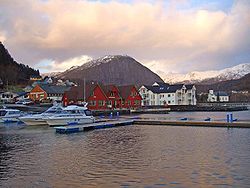 View of the village | |
 Askvoll Location in Sogn og Fjordane county  Askvoll Askvoll (Norway) | |
| Coordinates: 61°20′48″N05°03′43″E / 61.34667°N 5.06194°E Coordinates: 61°20′48″N05°03′43″E / 61.34667°N 5.06194°E | |
| Country | Norway |
| Region | Western Norway |
| County | Sogn og Fjordane |
| District | Sunnfjord |
| Municipality | Askvoll Municipality |
| Area [1] | |
| • Total | 0.69 km2 (0.27 sq mi) |
| Elevation [2] | 7 m (23 ft) |
| Population (2013) [1] | |
| • Total | 661 |
| • Density | 958/km2 (2,480/sq mi) |
| Time zone | CET (UTC+01:00) |
| • Summer (DST) | CEST (UTC+02:00) |
| Post Code | 6980 Askvoll |
Askvoll is the administrative centre of Askvoll Municipality in Sogn og Fjordane county, Norway. The village is located on the western coast of the mainland, just north of the mouth of the Dalsfjorden in the Sunnfjord region of the county. The village lies about 6 kilometres (3.7 mi) west of the village of Holmedal and about 15 kilometres (9.3 mi) south of the village of Stongfjorden. The island of Atløyna lies a couple kilometres west of the village of Askvoll. [3]
An administrative centre is a seat of regional administration or local government, or a county town, or the place where the central administration of a commune is located.

Sogn og Fjordane is a county in western Norway, bordering Møre og Romsdal, Oppland, Buskerud, and Hordaland. The county administration is in the village of Hermansverk in Leikanger municipality. The largest town in the county is Førde.

Norway, officially the Kingdom of Norway, is a Nordic country in Northwestern Europe whose territory comprises the western and northernmost portion of the Scandinavian Peninsula; the remote island of Jan Mayen and the archipelago of Svalbard are also part of the Kingdom of Norway. The Antarctic Peter I Island and the sub-Antarctic Bouvet Island are dependent territories and thus not considered part of the kingdom. Norway also lays claim to a section of Antarctica known as Queen Maud Land.
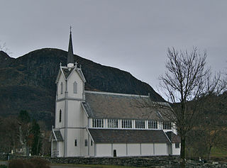
The 0.69-square-kilometre (170-acre) village has a population (2013) of 661, giving the village a population density of 958 inhabitants per square kilometre (2,480/sq mi). [1] Askvoll village is the site of the municipal administration as well as a primary and secondary school. The local police office, dental care, nursing care, and veterinary care are all located here. The village also features various shops, hotels, banks, and pharmacies. Askvoll Church, built in 1863, is located in the village. Askvoll has been a church site since the Middle Ages.

Population density is a measurement of population per unit area or unit volume; it is a quantity of type number density. It is frequently applied to living organisms, and most of the time to humans. It is a key geographical term. In simple terms population density refers to the number of people living in an area per kilometer square.

Askvoll Church is a parish church in Askvoll Municipality in Sogn og Fjordane county, Norway. It is located in the village of Askvoll. The church is part of the Askvoll parish in the Sunnfjord deanery in the Diocese of Bjørgvin. The white, wooden church has a seating capacity of 425, and it was consecrated on 13 December 1863 by the dean Johan Carl Christie. The artist Anders Askevold designed the church.

In the history of Europe, the Middle Ages lasted from the 5th to the 15th century. It began with the fall of the Western Roman Empire and merged into the Renaissance and the Age of Discovery. The Middle Ages is the middle period of the three traditional divisions of Western history: classical antiquity, the medieval period, and the modern period. The medieval period is itself subdivided into the Early, High, and Late Middle Ages.
The village has regular ferry connections to Fure (across the Dalsfjorden), to the island of Atløyna, and to the Værlandet-Bulandet islands.

Værlandet is an island in Askvoll Municipality in Sogn og Fjordane county, Norway. The 9-square-kilometre (3.5 sq mi) island lies immediately east of the Bulandet island group. The island of Alden lies about 2 kilometres (1.2 mi) northeast of Værlandet. The island lies about 16 kilometres (9.9 mi) west of the mainland coast of Askvoll, and it is only accessible by boat. There is a regular ferry route connecting Værlandet to the mainland village of Askvoll. There is a series of bridges that connect Værlandet to the islands of Bulandet to the west. Værlandet Chapel is located on the island. The Værlandet LORAN-C transmitter is located on the island.

Bulandet is an archipelago in the sea off the mainland coast of Western Norway. The island group is part of Askvoll Municipality in Sogn og Fjordane county, Norway. It sits about 20 kilometres (12 mi) west of the mainland coast of Askvoll. The islands of Værlandet and Alden lie immediately east of Bulandet. The Geita Lighthouse lies about 10 kilometres (6.2 mi) southeast of Bulandet.