Leusden is a municipality and a town in the Netherlands, in the province of Utrecht. It is located about 3 kilometres southeast of Amersfoort.
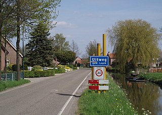
Uitweg is a hamlet in the Dutch province of Utrecht. It is a part of the municipality of Lopik, and lies about 5 km southwest of IJsselstein. The town consists almost completely of a ribbon of farms along the Enge IJssel and Lopiker Wetering rivers, between Graaf and Lopikerkapel.

Heemstede is a hamlet in the central Netherlands. It is located 3 km west of Houten, Utrecht. The hamlet is known for Heemstede Castle (1645).

Houtdijken is a hamlet in the Dutch province of Utrecht. It is a part of the municipality of Woerden, and lies about 4 km northeast of Woerden.

Oud-Aa is a hamlet in the Dutch province of Utrecht (province). It is a part of the municipality of Stichtse Vecht, and lies about 13 km northeast of Woerden.

Spengen is a hamlet in the Dutch province of Utrecht (province). It is a part of the municipality of Stichtse Vecht, and lies about 10 km northeast of Woerden.

Middelkoop is a hamlet in the Dutch province of Utrecht. It is a part of the municipality of Vijfheerenlanden, and lies about 11 km south of IJsselstein.

Achterdijk is a hamlet in the Dutch province of Utrecht. It is a part of the municipality of Vijfheerenlanden, and lies about 7 km northeast of Gorinchem.

Stoutenburg is a village in the Dutch province of Utrecht. It is a part of the municipality of Leusden, and lies about 4 km (2 mi) east of Amersfoort. Since 1998, a part of the village is a neighbourhood in Amersfoort.

Oud-Leusden is a hamlet in the Dutch province of Utrecht. It is a part of the municipality of Leusden, and lies about 4 km south of Amersfoort.
Prinsenkamp is a hamlet in the Dutch province of Gelderland. It is a part of the municipality of Nijkerk, and lies about 16 km east of Amersfoort.

Cattenbroek is a hamlet in the Dutch province of Utrecht. It is a part of the municipality of Montfoort, and lies about 4 km east of Woerden.

Stokkelaarsbrug is a hamlet in the Dutch province of Utrecht. It is a part of the municipality of De Ronde Venen, and lies about 12 km south of Amsterdam. It is located on the border with the province North Holland, where the small river Winkel joins the Oude Waver.
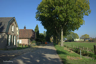
Luchtenburg is a hamlet in the Dutch province of Gelderland. It is a part of the municipality of Buren, and is located in about 8 km southwest of Veenendaal.

Willige Langerak is a hamlet in the Dutch provinces of South Holland and Utrecht. It is located in the municipalities of Krimpenerwaard and Lopik, just east of Schoonhoven.

Peizerwold is a hamlet in the Netherlands and it part of the Noordenveld municipality in Drenthe.

Jonas is a hamlet in the Dutch province of Gelderland. It lies east of the village of Vaassen, on the western side of the Apeldoornsch Kanaal.

Baars is a hamlet in the Dutch province of Overijssel. It is located in the municipality Steenwijkerland, about 4 km northwest of the town of Steenwijk.

Appel is a hamlet in the Dutch province of Gelderland. It is located in the municipality Nijkerk, about 6 km southeast of the city, on the border with the municipality of Barneveld.

Doornik is a hamlet in the municipality of Lingewaard, between Lent and Bemmel, in the province of Gelderland, the Netherlands. Most of Doornik was destroyed at a Dyke breach in 1799, the village never recovered. Doornik had an own castle which burned down in 1823.