List of cities, towns and villages in Utrecht

Last updated

This is a list of towns, cities, and villages in the province of Utrecht in the Netherlands.

NameMunicipalityCoordinates
Aan de Zuwe De Ronde Venen 52°10′20″N4°54′05″E / 52.17222°N 4.90139°E / 52.17222; 4.90139 (Aan de Zuwe)
Abcoude De Ronde Venen 52°16′20″N4°58′10″E / 52.27222°N 4.96944°E / 52.27222; 4.96944 (Abcoude)
Achterberg Rhenen 51°58′20″N5°35′15″E / 51.97222°N 5.58750°E / 51.97222; 5.58750 (Achterberg)
Achterbos De Ronde Venen 52°13′30″N4°55′35″E / 52.22500°N 4.92639°E / 52.22500; 4.92639 (Achterbos)
Achterdijk Vijfheerenlanden 51°53′30″N5°02′20″E / 51.89167°N 5.03889°E / 51.89167; 5.03889 (Achterdijk (Utrecht))
Achterveld Leusden 52°08′10″N5°29′50″E / 52.13611°N 5.49722°E / 52.13611; 5.49722 (Achterveld)
Achterwetering De Bilt 52°09′05″N5°09′10″E / 52.15139°N 5.15278°E / 52.15139; 5.15278 (Achterwetering)
Achthoven Vijfheerenlanden 51°58′05″N4°59′35″E / 51.96806°N 4.99306°E / 51.96806; 4.99306 (Achthoven)
Achthoven-Oost Montfoort 52°03′20″N5°00′10″E / 52.05556°N 5.00278°E / 52.05556; 5.00278 (Achthoven-Oost)
Achthoven-West Montfoort 52°03′25″N4°59′05″E / 52.05694°N 4.98472°E / 52.05694; 4.98472 (Achthoven-West)
Achttienhoven De Bilt 52°09′00″N5°10′00″E / 52.15000°N 5.16667°E / 52.15000; 5.16667 (Achttienhoven) (VUGA, 1997)
Alendorp Utrecht 52°05′35″N5°02′05″E / 52.09306°N 5.03472°E / 52.09306; 5.03472 (Alendorp)
Ameide Vijfheerenlanden 51°57′20″N4°57′45″E / 51.95556°N 4.96250°E / 51.95556; 4.96250 (Ameide)
Amerongen Utrechtse Heuvelrug 52°00′10″N5°27′35″E / 52.00278°N 5.45972°E / 52.00278; 5.45972 (Amerongen)
Amersfoort Amersfoort 52°09′20″N5°23′15″E / 52.15556°N 5.38750°E / 52.15556; 5.38750 (Amersfoort)
Amstelhoek De Ronde Venen 52°13′50″N4°50′00″E / 52.23056°N 4.83333°E / 52.23056; 4.83333 (Amstelhoek)
Asschat Leusden 52°07′55″N5°27′20″E / 52.13194°N 5.45556°E / 52.13194; 5.45556 (Asschat)
Austerlitz Zeist 52°04′45″N5°18′55″E / 52.07917°N 5.31528°E / 52.07917; 5.31528 (Austerlitz (Netherlands))
Baambrugge De Ronde Venen 52°14′45″N4°59′20″E / 52.24583°N 4.98889°E / 52.24583; 4.98889 (Baambrugge)
Baambrugse Zuwe De Ronde Venen 52°13′45″N4°57′05″E / 52.22917°N 4.95139°E / 52.22917; 4.95139 (Baambrugse Zuwe)
Baarn Baarn 52°12′40″N5°17′15″E / 52.21111°N 5.28750°E / 52.21111; 5.28750 (Baarn)
Barwoutswaarder Woerden 52°05′05″N4°51′00″E / 52.08472°N 4.85000°E / 52.08472; 4.85000 (Barwoutswaarder)
Beerschoten Utrechtse Heuvelrug 52°03′45″N5°15′15″E / 52.06250°N 5.25417°E / 52.06250; 5.25417 (Beerschoten)
Bekenes Woerden 52°04′40″N4°50′05″E / 52.07778°N 4.83472°E / 52.07778; 4.83472 (Bekenes)
Benedeneind Veenendaal 52°00′55″N5°34′50″E / 52.01528°N 5.58056°E / 52.01528; 5.58056 (Benedeneind)
Benschop Lopik 52°00′30″N4°58′50″E / 52.00833°N 4.98056°E / 52.00833; 4.98056 (Benschop)
Bilthoven De Bilt 52°07′45″N5°12′05″E / 52.12917°N 5.20139°E / 52.12917; 5.20139 (Bilthoven)
Blauwkapel De Bilt 52°06′45″N5°09′10″E / 52.11250°N 5.15278°E / 52.11250; 5.15278 (Blauwkapel)
Blokland Montfoort 52°02′10″N4°57′40″E / 52.03611°N 4.96111°E / 52.03611; 4.96111 (Blokland (Utrecht))
Boeicop Vijfheerenlanden 51°56′00″N5°07′00″E / 51.93333°N 5.11667°E / 51.93333; 5.11667 (Boeicop) Now part of Hei- en Boeicop.
Bosch en Duin Zeist 52°07′00″N5°14′30″E / 52.11667°N 5.24167°E / 52.11667; 5.24167 (Bosch en Duin)
Breedeveen Utrechtse Heuvelrug 52°01′25″N5°25′05″E / 52.02361°N 5.41806°E / 52.02361; 5.41806 (Breedeveen)
Breeveld Woerden 52°06′15″N4°55′50″E / 52.10417°N 4.93056°E / 52.10417; 4.93056 (Breeveld)
Breudijk Woerden 52°06′10″N4°57′40″E / 52.10278°N 4.96111°E / 52.10278; 4.96111 (Breudijk)
Breukelen Stichtse Vecht 52°10′30″N5°00′05″E / 52.17500°N 5.00139°E / 52.17500; 5.00139 (Breukelen)
Broek Vijfheerenlanden 51°55′55″N4°58′20″E / 51.93194°N 4.97222°E / 51.93194; 4.97222 (Broek (Vijfheerenlanden))
Bunnik Bunnik 52°04′00″N5°11′55″E / 52.06667°N 5.19861°E / 52.06667; 5.19861 (Bunnik)
Bunschoten Bunschoten 52°14′00″N5°23′00″E / 52.23333°N 5.38333°E / 52.23333; 5.38333 (Bunschoten) Now part of Bunschoten-Spakenburg.
Bunschoten-Spakenburg Bunschoten 52°14′40″N5°22′20″E / 52.24444°N 5.37222°E / 52.24444; 5.37222 (Bunschoten-Spakenburg)
Buurtsdijk Amersfoort 52°12′05″N5°25′45″E / 52.20139°N 5.42917°E / 52.20139; 5.42917 (Buurtsdijk)
Cabauw Lopik 51°57′50″N4°53′55″E / 51.96389°N 4.89861°E / 51.96389; 4.89861 (Cabauw)
Cattenbroek Montfoort 52°04′00″N4°56′10″E / 52.06667°N 4.93611°E / 52.06667; 4.93611 (Cattenbroek)
Cothen Wijk bij Duurstede 51°59′50″N5°18′30″E / 51.99722°N 5.30833°E / 51.99722; 5.30833 (Cothen)
Darthuizen Utrechtse Heuvelrug 52°00′45″N5°23′25″E / 52.01250°N 5.39028°E / 52.01250; 5.39028 (Darthuizen)
Dashorst Woudenberg 52°07′00″N5°29′00″E / 52.11667°N 5.48333°E / 52.11667; 5.48333 (Dashorst) Former hamlet.
De Bilt De Bilt 52°06′35″N5°10′50″E / 52.10972°N 5.18056°E / 52.10972; 5.18056 (De Bilt)
De Birkt Soest 52°09′40″N5°19′55″E / 52.16111°N 5.33194°E / 52.16111; 5.33194 (De Birkt)
De Brand Amersfoort 52°11′00″N5°24′00″E / 52.18333°N 5.40000°E / 52.18333; 5.40000 (De Brand) Former hamlet; now part of Amersfoort
De Bree Woerden 52°04′50″N4°49′40″E / 52.08056°N 4.82778°E / 52.08056; 4.82778 (De Bree)
De Bunt Soest 52°09′00″N5°20′00″E / 52.15000°N 5.33333°E / 52.15000; 5.33333 (De Bunt) Former hamlet.
De Glashut Stichtse Vecht 52°13′05″N5°01′55″E / 52.21806°N 5.03194°E / 52.21806; 5.03194 (De Glashut)
De Groep Utrechtse Heuvelrug 52°03′05″N5°30′15″E / 52.05139°N 5.50417°E / 52.05139; 5.50417 (De Groep)
De Heul Houten 51°59′00″N5°14′00″E / 51.98333°N 5.23333°E / 51.98333; 5.23333 (De Heul) (VUGA 1997)
De Hoef De Ronde Venen 52°12′05″N4°48′55″E / 52.20139°N 4.81528°E / 52.20139; 4.81528 (De Hoef)
De Meern Utrecht 52°04′55″N5°02′10″E / 52.08194°N 5.03611°E / 52.08194; 5.03611 (De Meern)
Demmerik De Ronde Venen 52°12′15″N4°55′55″E / 52.20417°N 4.93194°E / 52.20417; 4.93194 (Demmerik)
Den Bosch De Ronde Venen 52°11′00″N4°57′00″E / 52.18333°N 4.95000°E / 52.18333; 4.95000 (Den Bosch (Utrecht)) Former hamlet.
Den Dolder Zeist 52°08′20″N5°14′20″E / 52.13889°N 5.23889°E / 52.13889; 5.23889 (Den Dolder)
Den Ham Amersfoort 52°11′00″N5°24′00″E / 52.18333°N 5.40000°E / 52.18333; 5.40000 (Den Ham (Amersfoort)) Former hamlet; now part of Amersfoort.
Den Oord Wijk bij Duurstede 51°58′15″N5°16′15″E / 51.97083°N 5.27083°E / 51.97083; 5.27083 (Den Oord)
Den Treek Leusden 52°06′15″N5°23′25″E / 52.10417°N 5.39028°E / 52.10417; 5.39028 (Den Treek)
De Ruif Leusden 52°09′25″N5°26′35″E / 52.15694°N 5.44306°E / 52.15694; 5.44306 (De Ruif)
Diefdijk Vijfheerenlanden 51°54′50″N5°07′50″E / 51.91389°N 5.13056°E / 51.91389; 5.13056 (Diefdijk)
Diemerbroek Oudewater 52°03′10″N4°51′45″E / 52.05278°N 4.86250°E / 52.05278; 4.86250 (Diemerbroek)
Donkereind De Ronde Venen 52°11′30″N4°55′30″E / 52.19167°N 4.92500°E / 52.19167; 4.92500 (Donkereind)
Donkervliet De Ronde Venen 52°14′00″N5°00′00″E / 52.23333°N 5.00000°E / 52.23333; 5.00000 (Donkervliet) Former hamlet.
Doorn Utrechtse Heuvelrug 52°02′15″N5°20′30″E / 52.03750°N 5.34167°E / 52.03750; 5.34167 (Doorn)
Driebergen Utrechtse Heuvelrug 52°03′00″N5°17′00″E / 52.05000°N 5.28333°E / 52.05000; 5.28333 (Driebergen) Now part of Driebergen-Rijsenburg.
Driebergen-Rijsenburg Utrechtse Heuvelrug 52°03′15″N5°16′50″E / 52.05417°N 5.28056°E / 52.05417; 5.28056 (Driebergen-Rijsenburg)
Dwarsdijk Wijk bij Duurstede 51°59′20″N5°16′50″E / 51.98889°N 5.28056°E / 51.98889; 5.28056 (Dwarsdijk)
Eembrugge Eemnes 52°13′35″N5°18′35″E / 52.22639°N 5.30972°E / 52.22639; 5.30972 (Eembrugge)
Eemdijk Bunschoten 52°15′20″N5°19′50″E / 52.25556°N 5.33056°E / 52.25556; 5.33056 (Eemdijk)
Eemnes Eemnes 52°15′15″N5°15′40″E / 52.25417°N 5.26111°E / 52.25417; 5.26111 (Eemnes)
Elst Rhenen 51°59′15″N5°29′50″E / 51.98750°N 5.49722°E / 51.98750; 5.49722 (Elst (Utrecht))
Emminkhuizen Renswoude 52°03′05″N5°31′45″E / 52.05139°N 5.52917°E / 52.05139; 5.52917 (Emminkhuizen)
Everdingen Vijfheerenlanden 51°57′55″N5°09′20″E / 51.96528°N 5.15556°E / 51.96528; 5.15556 (Everdingen)
Geer, De Ronde Venen De Ronde Venen 52°09′50″N4°54′50″E / 52.16389°N 4.91389°E / 52.16389; 4.91389 (Geer, De Ronde Venen)
Geer, Vijfheerenlanden Vijfheerenlanden 51°54′10″N5°02′45″E / 51.90278°N 5.04583°E / 51.90278; 5.04583 (Geer, Vijfheerenlanden)
Geerestein Woudenberg 52°05′00″N5°25′00″E / 52.08333°N 5.41667°E / 52.08333; 5.41667 (Geerestein) Former hamlet.
Geestdorp Woerden 52°05′50″N4°54′25″E / 52.09722°N 4.90694°E / 52.09722; 4.90694 (Geestdorp)
Gemaal De Ronde Venen 52°15′10″N4°54′15″E / 52.25278°N 4.90417°E / 52.25278; 4.90417 (Gemaal)
Gerverscop Woerden 52°07′05″N4°57′00″E / 52.11806°N 4.95000°E / 52.11806; 4.95000 (Gerverscop)
Gieltjesdorp Stichtse Vecht 52°08′00″N4°59′00″E / 52.13333°N 4.98333°E / 52.13333; 4.98333 (Gieltjesdorp) (VUGA, 1997)
Goyse Dorp Houten 52°00′00″N5°13′00″E / 52.00000°N 5.21667°E / 52.00000; 5.21667 (Goyse Dorp) Former hamlet.
Graaf Lopik 51°58′50″N4°58′45″E / 51.98056°N 4.97917°E / 51.98056; 4.97917 (Graaf (village))
Groenekan De Bilt 52°07′25″N5°09′10″E / 52.12361°N 5.15278°E / 52.12361; 5.15278 (Groenekan)
Groenlandsekade De Ronde Venen 52°13′55″N4°58′40″E / 52.23194°N 4.97778°E / 52.23194; 4.97778 (Groenlandsekade)
Grote Melm Soest 52°11′30″N5°18′35″E / 52.19167°N 5.30972°E / 52.19167; 5.30972 (Grote Melm)
Haagje Utrechtse Heuvelrug 52°04′00″N5°16′20″E / 52.06667°N 5.27222°E / 52.06667; 5.27222 (Haagje)
Haanwijk Woerden 52°06′00″N4°57′00″E / 52.10000°N 4.95000°E / 52.10000; 4.95000 (Haanwijk) Former hamlet.
Haarzuilens Utrecht 52°07′15″N4°59′50″E / 52.12083°N 4.99722°E / 52.12083; 4.99722 (Haarzuilens)
Hagestein Vijfheerenlanden 51°58′50″N5°07′20″E / 51.98056°N 5.12222°E / 51.98056; 5.12222 (Hagestein)
Harmelen Woerden 52°05′25″N4°57′40″E / 52.09028°N 4.96111°E / 52.09028; 4.96111 (Harmelen)
Harmelerwaard Woerden 52°05′20″N4°59′00″E / 52.08889°N 4.98333°E / 52.08889; 4.98333 (Harmelerwaard)
Haspel Utrechtse Heuvelrug 52°01′55″N5°31′10″E / 52.03194°N 5.51944°E / 52.03194; 5.51944 (Haspel)
Heemstede Houten 52°02′05″N5°07′30″E / 52.03472°N 5.12500°E / 52.03472; 5.12500 (Heemstede (Utrecht))
Hees Soest 52°09′45″N5°16′25″E / 52.16250°N 5.27361°E / 52.16250; 5.27361 (Hees)
Heeswijk Montfoort 52°03′05″N4°58′10″E / 52.05139°N 4.96944°E / 52.05139; 4.96944 (Heeswijk (Utrecht))
Hei- en Boeicop Vijfheerenlanden 51°56′45″N5°04′55″E / 51.94583°N 5.08194°E / 51.94583; 5.08194 (Hei- en Boeicop)
Hekendorp Oudewater 52°00′55″N4°48′30″E / 52.01528°N 4.80833°E / 52.01528; 4.80833 (Hekendorp)
Helsdingen Vijfheerenlanden 51°58′40″N5°03′55″E / 51.97778°N 5.06528°E / 51.97778; 5.06528 (Helsdingen)
Hoenkoop Oudewater 52°00′05″N4°50′30″E / 52.00139°N 4.84167°E / 52.00139; 4.84167 (Hoenkoop)
Hollandsche Rading De Bilt 52°10′30″N5°10′40″E / 52.17500°N 5.17778°E / 52.17500; 5.17778 (Hollandsche Rading)
Honswijk Houten 51°58′20″N5°10′45″E / 51.97222°N 5.17917°E / 51.97222; 5.17917 (Honswijk, Houten)
Hoogeind Vijfheerenlanden 51°54′50″N5°05′15″E / 51.91389°N 5.08750°E / 51.91389; 5.08750 (Hoogeind)
Hoogewaard Vijfheerenlanden 51°57′15″N4°57′20″E / 51.95417°N 4.95556°E / 51.95417; 4.95556 (Hoogewaard)
Hoogland Amersfoort 52°10′55″N5°22′25″E / 52.18194°N 5.37361°E / 52.18194; 5.37361 (Hoogland)
Hooglanderveen Amersfoort 52°11′20″N5°25′45″E / 52.18889°N 5.42917°E / 52.18889; 5.42917 (Hooglanderveen)
Houtdijken Woerden 52°06′25″N4°55′35″E / 52.10694°N 4.92639°E / 52.10694; 4.92639 (Houtdijken)
Houten Houten 52°01′40″N5°10′05″E / 52.02778°N 5.16806°E / 52.02778; 5.16806 (Houten)
Huis ter Heide Zeist 52°06′45″N5°15′20″E / 52.11250°N 5.25556°E / 52.11250; 5.25556 (Huis ter Heide)
IJsselstein IJsselstein 52°01′10″N5°02′35″E / 52.01944°N 5.04306°E / 52.01944; 5.04306 (IJsselstein)
Jaarsveld Lopik 51°58′10″N4°58′35″E / 51.96944°N 4.97639°E / 51.96944; 4.97639 (Jaarsveld)
Jannendorp Leusden 52°08′35″N5°29′45″E / 52.14306°N 5.49583°E / 52.14306; 5.49583 (Jannendorp)
Kamerik Woerden 52°06′40″N4°53′40″E / 52.11111°N 4.89444°E / 52.11111; 4.89444 (Kamerik)
Kamerik-Mijzijde Woerden 52°07′30″N4°53′00″E / 52.12500°N 4.88333°E / 52.12500; 4.88333 (Kamerik-Mijzijde)
Kanis Woerden 52°07′30″N4°53′30″E / 52.12500°N 4.89167°E / 52.12500; 4.89167 (Kanis)
Kedichem Vijfheerenlanden 51°51′35″N5°03′00″E / 51.85972°N 5.05000°E / 51.85972; 5.05000 (Kedichem)
Kerklaan Stichtse Vecht 52°13′15″N5°00′30″E / 52.22083°N 5.00833°E / 52.22083; 5.00833 (Kerklaan)
Knollemanshoek IJsselstein 52°03′00″N4°59′35″E / 52.05000°N 4.99306°E / 52.05000; 4.99306 (Knollemanshoek)
Kockengen Stichtse Vecht 52°08′55″N4°57′00″E / 52.14861°N 4.95000°E / 52.14861; 4.95000 (Kockengen)
Kortenhoeven Vijfheerenlanden 51°58′25″N5°02′55″E / 51.97361°N 5.04861°E / 51.97361; 5.04861 (Kortenhoeven)
Kortgerecht Vijfheerenlanden 51°55′40″N5°07′25″E / 51.92778°N 5.12361°E / 51.92778; 5.12361 (Kortgerecht)
Kortrijk Stichtse Vecht 52°09′25″N4°59′05″E / 52.15694°N 4.98472°E / 52.15694; 4.98472 (Kortrijk (Netherlands))
Kromme Mijdrecht De Ronde Venen 52°13′30″N4°49′05″E / 52.22500°N 4.81806°E / 52.22500; 4.81806 (Kromme Mijdrecht)
Kromwijk Woerden 52°04′25″N4°52′55″E / 52.07361°N 4.88194°E / 52.07361; 4.88194 (Kromwijk)
Laagnieuwkoop Stichtse Vecht 52°07′50″N4°58′35″E / 52.13056°N 4.97639°E / 52.13056; 4.97639 (Laagnieuwkoop)
Laareind Rhenen 51°57′40″N5°36′20″E / 51.96111°N 5.60556°E / 51.96111; 5.60556 (Laareind)
Lagebroek De Ronde Venen 52°07′35″N4°50′15″E / 52.12639°N 4.83750°E / 52.12639; 4.83750 (Lagebroek)
Lage Vuursche Baarn 52°10′45″N5°13′25″E / 52.17917°N 5.22361°E / 52.17917; 5.22361 (Lage-Vuursche)
Lakerveld Vijfheerenlanden 51°56′35″N5°01′10″E / 51.94306°N 5.01944°E / 51.94306; 5.01944 (Lakerveld)
Langbroek Wijk bij Duurstede 52°00′45″N5°19′40″E / 52.01250°N 5.32778°E / 52.01250; 5.32778 (Langbroek)
Lange Linschoten Oudewater 52°02′30″N4°53′20″E / 52.04167°N 4.88889°E / 52.04167; 4.88889 (Lange Linschoten)
Leerbroek Vijfheerenlanden 51°54′30″N5°03′05″E / 51.90833°N 5.05139°E / 51.90833; 5.05139 (Leerbroek)
Leerdam Vijfheerenlanden 51°53′35″N5°05′30″E / 51.89306°N 5.09167°E / 51.89306; 5.09167 (Leerdam)
Leersum Utrechtse Heuvelrug 52°00′40″N5°25′40″E / 52.01111°N 5.42778°E / 52.01111; 5.42778 (Leersum)
Leusden Leusden 52°08′00″N5°25′55″E / 52.13333°N 5.43194°E / 52.13333; 5.43194 (Leusden)
Leusden-Zuid Leusden 52°07′05″N5°24′20″E / 52.11806°N 5.40556°E / 52.11806; 5.40556 (Leusden-Zuid)
Lexmond Vijfheerenlanden 51°57′45″N5°02′05″E / 51.96250°N 5.03472°E / 51.96250; 5.03472 (Lexmond)
Linschoten Montfoort 52°03′45″N4°54′55″E / 52.06250°N 4.91528°E / 52.06250; 4.91528 (Linschoten)
Loenen aan de Vecht Stichtse Vecht 52°12′35″N5°01′20″E / 52.20972°N 5.02222°E / 52.20972; 5.02222 (Loenen aan de Vecht)
Loenersloot Stichtse Vecht 52°13′45″N5°00′05″E / 52.22917°N 5.00139°E / 52.22917; 5.00139 (Loenersloot)
Loosdorp Vijfheerenlanden 51°54′10″N5°05′20″E / 51.90278°N 5.08889°E / 51.90278; 5.08889 (Loosdorp)
Lopik Lopik 51°58′20″N4°56′55″E / 51.97222°N 4.94861°E / 51.97222; 4.94861 (Lopik)
Lopikerkapel Lopik 51°59′30″N5°02′45″E / 51.99167°N 5.04583°E / 51.99167; 5.04583 (Lopikerkapel)
Maarn Utrechtse Heuvelrug 52°03′50″N5°22′15″E / 52.06389°N 5.37083°E / 52.06389; 5.37083 (Maarn)
Maarsbergen Utrechtse Heuvelrug 52°03′30″N5°24′20″E / 52.05833°N 5.40556°E / 52.05833; 5.40556 (Maarsbergen)
Maarssen Stichtse Vecht 52°08′20″N5°02′30″E / 52.13889°N 5.04167°E / 52.13889; 5.04167 (Maarssen)
Maartensdijk De Bilt 52°09′20″N5°10′30″E / 52.15556°N 5.17500°E / 52.15556; 5.17500 (Maartensdijk)
Mastwijk Montfoort 52°03′15″N4°57′20″E / 52.05417°N 4.95556°E / 52.05417; 4.95556 (Mastwijk)
Meerkerk Vijfheerenlanden 51°55′10″N4°59′40″E / 51.91944°N 4.99444°E / 51.91944; 4.99444 (Meerkerk)
Middelkoop Vijfheerenlanden 51°55′25″N5°03′10″E / 51.92361°N 5.05278°E / 51.92361; 5.05278 (Middelkoop)
Mijdrecht De Ronde Venen 52°12′25″N4°51′45″E / 52.20694°N 4.86250°E / 52.20694; 4.86250 (Mijdrecht)
Mijnden Stichtse Vecht 52°11′45″N5°00′40″E / 52.19583°N 5.01111°E / 52.19583; 5.01111 (Mijnden)
Molenbuurt Houten 51°59′15″N5°09′45″E / 51.98750°N 5.16250°E / 51.98750; 5.16250 (Molenbuurt)
Molenpolder Stichtse Vecht 52°08′50″N5°05′00″E / 52.14722°N 5.08333°E / 52.14722; 5.08333 (Molenpolder)
Montfoort Montfoort 52°02′45″N4°57′10″E / 52.04583°N 4.95278°E / 52.04583; 4.95278 (Montfoort)
Musschendorp Leusden 52°08′50″N5°27′20″E / 52.14722°N 5.45556°E / 52.14722; 5.45556 (Musschendorp)
Nessersluis De Ronde Venen 52°14′55″N4°51′55″E / 52.24861°N 4.86528°E / 52.24861; 4.86528 (Nessersluis)
Nieuwegein Nieuwegein 52°01′45″N5°04′50″E / 52.02917°N 5.08056°E / 52.02917; 5.08056 (Nieuwegein)
Nieuwerhoek Stichtse Vecht 52°12′15″N5°01′05″E / 52.20417°N 5.01806°E / 52.20417; 5.01806 (Nieuwerhoek)
Nieuwersluis Stichtse Vecht 52°12′00″N5°01′00″E / 52.20000°N 5.01667°E / 52.20000; 5.01667 (Nieuwersluis) (VUGA, 1997)
Nieuwer-Ter-Aa Stichtse Vecht 52°11′25″N4°58′50″E / 52.19028°N 4.98056°E / 52.19028; 4.98056 (Nieuwer-Ter-Aa)
Nieuwe-Wetering De Bilt 52°08′25″N5°09′55″E / 52.14028°N 5.16528°E / 52.14028; 5.16528 (Nieuwe-Wetering)
Nieuwland Vijfheerenlanden 51°54′05″N5°00′50″E / 51.90139°N 5.01389°E / 51.90139; 5.01389 (Nieuwland, Vijfheerenlanden)
Nigtevecht Stichtse Vecht 52°16′25″N5°01′40″E / 52.27361°N 5.02778°E / 52.27361; 5.02778 (Nigtevecht)
Noordeinde Stichtse Vecht 52°10′00″N4°57′00″E / 52.16667°N 4.95000°E / 52.16667; 4.95000 (Noordeinde (Utrecht))
Ockhuizen Utrecht 52°07′40″N4°59′50″E / 52.12778°N 4.99722°E / 52.12778; 4.99722 (Ockhuizen)
Odijk Bunnik 52°03′10″N5°14′10″E / 52.05278°N 5.23611°E / 52.05278; 5.23611 (Odijk)
Oosterwijk Vijfheerenlanden 51°52′40″N5°04′45″E / 51.87778°N 5.07917°E / 51.87778; 5.07917 (Oosterwijk)
Oud-Aa Stichtse Vecht 52°10′55″N4°58′25″E / 52.18194°N 4.97361°E / 52.18194; 4.97361 (Oud-Aa)
Oudenrijn Utrecht 52°04′55″N5°04′10″E / 52.08194°N 5.06944°E / 52.08194; 5.06944 (Oudenrijn)
Oudewater Oudewater 52°01′30″N4°52′05″E / 52.02500°N 4.86806°E / 52.02500; 4.86806 (Oudewater)
Oud-Kamerik Woerden 52°08′15″N4°54′10″E / 52.13750°N 4.90278°E / 52.13750; 4.90278 (Oud-Kamerik)
Oud-Leusden Leusden 52°07′50″N5°22′20″E / 52.13056°N 5.37222°E / 52.13056; 5.37222 (Oud-Leusden)
Oud-Maarsseveen Stichtse Vecht 52°09′30″N5°05′25″E / 52.15833°N 5.09028°E / 52.15833; 5.09028 (Oud-Maarsseveen) (VUGA, 1997)
Oud-Wulven Houten 52°02′35″N5°09′20″E / 52.04306°N 5.15556°E / 52.04306; 5.15556 (Oud-Wulven)
Oud-Zuilen Stichtse Vecht 52°07′40″N5°04′05″E / 52.12778°N 5.06806°E / 52.12778; 5.06806 (Oud-Zuilen)
Oukoop Stichtse Vecht 52°12′15″N4°58′35″E / 52.20417°N 4.97639°E / 52.20417; 4.97639 (Oukoop (Utrecht))
Overberg Utrechtse Heuvelrug 52°02′25″N5°29′40″E / 52.04028°N 5.49444°E / 52.04028; 5.49444 (Overberg (Netherlands))
Overboeicop Vijfheerenlanden 51°56′10″N5°06′40″E / 51.93611°N 5.11111°E / 51.93611; 5.11111 (Overboeicop)
Overheicop Vijfheerenlanden 51°55′30″N5°06′10″E / 51.92500°N 5.10278°E / 51.92500; 5.10278 (Overheicop)
Overlangbroek Wijk bij Duurstede 51°59′30″N5°22′50″E / 51.99167°N 5.38056°E / 51.99167; 5.38056 (Overlangbroek)
Palestina Amersfoort 52°12′30″N5°25′40″E / 52.20833°N 5.42778°E / 52.20833; 5.42778 (Palestina (Netherlands))
Palmstad Utrechtse Heuvelrug 52°02′10″N5°19′15″E / 52.03611°N 5.32083°E / 52.03611; 5.32083 (Palmstad)
Papekop Oudewater 52°02′45″N4°51′10″E / 52.04583°N 4.85278°E / 52.04583; 4.85278 (Papekop)
Pijnenburg Soest 52°10′15″N5°14′45″E / 52.17083°N 5.24583°E / 52.17083; 5.24583 (Pijnenburg)
Polsbroek Lopik 51°58′40″N4°51′10″E / 51.97778°N 4.85278°E / 51.97778; 4.85278 (Polsbroek)
Polsbroekerdam Lopik 51°59′40″N4°54′10″E / 51.99444°N 4.90278°E / 51.99444; 4.90278 (Polsbroekerdam)
Portengen Stichtse Vecht 52°09′15″N4°57′55″E / 52.15417°N 4.96528°E / 52.15417; 4.96528 (Portengen)
Portengense Brug Stichtse Vecht 52°09′40″N4°57′30″E / 52.16111°N 4.95833°E / 52.16111; 4.95833 (Portengense Brug)
Reijerscop Woerden 52°04′35″N4°58′35″E / 52.07639°N 4.97639°E / 52.07639; 4.97639 (Reijerscop)
Remmerden Rhenen 51°58′25″N5°32′00″E / 51.97361°N 5.53333°E / 51.97361; 5.53333 (Remmerden)
Renswoude Renswoude 52°04′25″N5°32′25″E / 52.07361°N 5.54028°E / 52.07361; 5.54028 (Renswoude)
Rhenen Rhenen 51°57′35″N5°34′05″E / 51.95972°N 5.56806°E / 51.95972; 5.56806 (Rhenen)
Rietveld Woerden 52°05′20″N4°50′45″E / 52.08889°N 4.84583°E / 52.08889; 4.84583 (Rietveld (Utrecht))
Rijsenburg Utrechtse Heuvelrug 52°03′00″N5°16′00″E / 52.05000°N 5.26667°E / 52.05000; 5.26667 (Rijsenburg) Now part of Driebergen-Rijsenburg.
Ruigeweide Oudewater 52°01′45″N4°49′45″E / 52.02917°N 4.82917°E / 52.02917; 4.82917 (Ruigeweide)
Sandenburg Wijk bij Duurstede 52°00′25″N5°20′40″E / 52.00694°N 5.34444°E / 52.00694; 5.34444 (Sandenburg)
Schalkwijk Houten 51°59′40″N5°11′15″E / 51.99444°N 5.18750°E / 51.99444; 5.18750 (Schalkwijk)
Scheendijk Stichtse Vecht 52°10′45″N5°01′20″E / 52.17917°N 5.02222°E / 52.17917; 5.02222 (Scheendijk)
Schoonrewoerd Vijfheerenlanden 51°55′15″N5°07′00″E / 51.92083°N 5.11667°E / 51.92083; 5.11667 (Schoonrewoerd)
Sluis Vijfheerenlanden 51°57′20″N4°58′40″E / 51.95556°N 4.97778°E / 51.95556; 4.97778 (Sluis (Utrecht))
Snelrewaard Oudewater 52°01′40″N4°54′30″E / 52.02778°N 4.90833°E / 52.02778; 4.90833 (Snelrewaard)
Snorrenhoef Leusden 52°07′40″N5°28′05″E / 52.12778°N 5.46806°E / 52.12778; 5.46806 (Snorrenhoef)
Soest Soest 52°10′25″N5°17′30″E / 52.17361°N 5.29167°E / 52.17361; 5.29167 (Soest (Netherlands))
Soestdijk Soest 52°11′30″N5°17′05″E / 52.19167°N 5.28472°E / 52.19167; 5.28472 (Soestdijk)
Soestduinen Soest 52°08′45″N5°18′00″E / 52.14583°N 5.30000°E / 52.14583; 5.30000 (Soestduinen)
Soesterberg Soest 52°07′05″N5°17′10″E / 52.11806°N 5.28611°E / 52.11806; 5.28611 (Soesterberg)
Spakenburg Bunschoten 52°15′00″N5°22′00″E / 52.25000°N 5.36667°E / 52.25000; 5.36667 (Spakenburg) Now part of Bunschoten-Spakenburg.
Spengen Stichtse Vecht 52°09′25″N4°57′55″E / 52.15694°N 4.96528°E / 52.15694; 4.96528 (Spengen)
Sterrenberg Zeist 52°06′50″N5°16′55″E / 52.11389°N 5.28194°E / 52.11389; 5.28194 (Sterrenberg)
Stokkelaarsbrug De Ronde Venen 52°16′10″N4°55′50″E / 52.26944°N 4.93056°E / 52.26944; 4.93056 (Stokkelaarsbrug)
Stoutenburg Leusden 52°09′10″N5°26′10″E / 52.15278°N 5.43611°E / 52.15278; 5.43611 (Stoutenburg)
Tappersheul Oudewater 52°02′10″N4°51′35″E / 52.03611°N 4.85972°E / 52.03611; 4.85972 (Tappersheul)
Teckop Woerden 52°08′00″N4°55′15″E / 52.13333°N 4.92083°E / 52.13333; 4.92083 (Teckop)
't Goy Houten 52°00′10″N5°13′25″E / 52.00278°N 5.22361°E / 52.00278; 5.22361 ('t Goy)
Themaat Utrecht 52°07′00″N5°00′35″E / 52.11667°N 5.00972°E / 52.11667; 5.00972 (Themaat)
Tienhoven, Everdingen Vijfheerenlanden 51°57′40″N5°08′20″E / 51.96111°N 5.13889°E / 51.96111; 5.13889 (Tienhoven, Everdingen)
Tienhoven, Stichtse Vecht Stichtse Vecht 52°09′55″N5°05′00″E / 52.16528°N 5.08333°E / 52.16528; 5.08333 (Tienhoven, Stichtse Vecht)
Tienhoven aan de Lek Vijfheerenlanden 51°57′35″N4°56′25″E / 51.95972°N 4.94028°E / 51.95972; 4.94028 (Tienhoven aan de Lek)
Tull en 't Waal Houten 52°00′05″N5°07′55″E / 52.00139°N 5.13194°E / 52.00139; 5.13194 (Tull en 't Waal)
't Zand Utrecht 52°05′35″N5°02′45″E / 52.09306°N 5.04583°E / 52.09306; 5.04583 (t Zand (Utrecht))
Uitweg Lopik 51°59′00″N5°01′00″E / 51.98333°N 5.01667°E / 51.98333; 5.01667 (Uitweg)
Utrecht Utrecht 52°05′30″N5°07′20″E / 52.09167°N 5.12222°E / 52.09167; 5.12222 (Utrecht (city))
Valkenheide Utrechtse Heuvelrug 52°02′25″N5°25′00″E / 52.04028°N 5.41667°E / 52.04028; 5.41667 (Valkenheide)
Vechten Bunnik 52°03′50″N5°10′20″E / 52.06389°N 5.17222°E / 52.06389; 5.17222 (Vechten)
Veenendaal Veenendaal 52°01′25″N5°33′00″E / 52.02361°N 5.55000°E / 52.02361; 5.55000 (Veenendaal)
Veldhuizen Utrecht 52°03′55″N5°00′40″E / 52.06528°N 5.01111°E / 52.06528; 5.01111 (Veldhuizen)
Vianen Vijfheerenlanden 51°59′30″N5°05′30″E / 51.99167°N 5.09167°E / 51.99167; 5.09167 (Vianen)
Vinkekade De Ronde Venen 52°14′30″N4°58′15″E / 52.24167°N 4.97083°E / 52.24167; 4.97083 (Vinkekade)
Vinkeveen De Ronde Venen 52°12′50″N4°55′40″E / 52.21389°N 4.92778°E / 52.21389; 4.92778 (Vinkeveen)
Vleuten Utrecht 52°06′20″N5°00′55″E / 52.10556°N 5.01528°E / 52.10556; 5.01528 (Vleuten)
Vliet Oudewater 52°01′00″N4°51′10″E / 52.01667°N 4.85278°E / 52.01667; 4.85278 (Vliet (Utrecht))
Voskuilen Woudenberg 52°06′15″N5°26′35″E / 52.10417°N 5.44306°E / 52.10417; 5.44306 (Voskuilen)
Vreeland Stichtse Vecht 52°13′50″N5°01′55″E / 52.23056°N 5.03194°E / 52.23056; 5.03194 (Vreeland)
Waverveen De Ronde Venen 52°13′20″N4°53′55″E / 52.22222°N 4.89861°E / 52.22222; 4.89861 (Waverveen)
Wayen Houten 52°03′00″N5°07′55″E / 52.05000°N 5.13194°E / 52.05000; 5.13194 (Wayen)
Werkhoven Bunnik 52°01′30″N5°14′40″E / 52.02500°N 5.24444°E / 52.02500; 5.24444 (Werkhoven)
Westbroek De Bilt 52°09′00″N5°07′30″E / 52.15000°N 5.12500°E / 52.15000; 5.12500 (Westbroek)
Weverwijk Vijfheerenlanden 51°54′45″N5°00′50″E / 51.91250°N 5.01389°E / 51.91250; 5.01389 (Weverwijk)
Wijk bij Duurstede Wijk bij Duurstede 51°58′30″N5°20′30″E / 51.97500°N 5.34167°E / 51.97500; 5.34167 (Wijk bij Duurstede)
Willeskop Montfoort 52°01′25″N4°54′40″E / 52.02361°N 4.91111°E / 52.02361; 4.91111 (Willeskop)
Willige Langerak Lopik 51°56′40″N4°52′45″E / 51.94444°N 4.87917°E / 51.94444; 4.87917 (Willige Langerak)
Wilnis De Ronde Venen 52°11′45″N4°53′50″E / 52.19583°N 4.89722°E / 52.19583; 4.89722 (Wilnis)
Woerden Woerden 52°05′05″N4°53′00″E / 52.08472°N 4.88333°E / 52.08472; 4.88333 (Woerden)
Woudenberg Woudenberg 52°04′50″N5°25′00″E / 52.08056°N 5.41667°E / 52.08056; 5.41667 (Woudenberg)
Zegveld Woerden 52°06′55″N4°50′10″E / 52.11528°N 4.83611°E / 52.11528; 4.83611 (Zegveld)
Zeist Zeist 52°05′25″N5°14′00″E / 52.09028°N 5.23333°E / 52.09028; 5.23333 (Zeist)
Zeldert Amersfoort 52°12′00″N5°21′45″E / 52.20000°N 5.36250°E / 52.20000; 5.36250 (Zeldert)
Zevender Lopik 51°57′25″N4°52′35″E / 51.95694°N 4.87639°E / 51.95694; 4.87639 (Zevender)
Zevenhuizen Bunschoten 52°12′40″N5°23′20″E / 52.21111°N 5.38889°E / 52.21111; 5.38889 (Zevenhuizen, Utrecht)
Zijderveld Vijfheerenlanden 51°56′30″N5°08′25″E / 51.94167°N 5.14028°E / 51.94167; 5.14028 (Zijderveld)
Zuideinde Stichtse Vecht 52°08′50″N4°58′20″E / 52.14722°N 4.97222°E / 52.14722; 4.97222 (Zuideinde, Utrecht)

See also

Related Research Articles

Utrecht City and municipality in the province of Utrecht, Netherlands

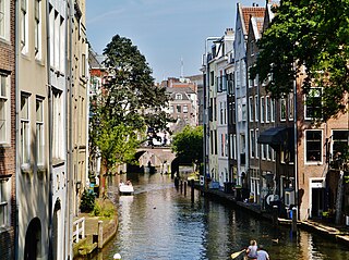
Utrecht is the fourth-largest city and a municipality of the Netherlands, capital and most populous city of the province of Utrecht. It is located in the eastern corner of the Randstad conurbation, in the very centre of mainland Netherlands; it has a population of 361,966 as of December 1, 2021.

Almere City and municipality in Flevoland, Netherlands

Almere is a planned city and municipality in the province of Flevoland, Netherlands, bordering Lelystad and Zeewolde. The municipality of Almere comprises six official areas that are the districts of Almere Stad, Almere Buiten and Almere Pampus, and the boroughs of Almere Haven, Almere Hout and Almere Poort. Four of them feature official district or borough offices. Furthermore, it also comprises the unofficial historic district and neighborhood Oostvaardersdiep, which has an active semi-self-governing community, and the planned district of Almere Oosterwold. Almere is part of the Amsterdam Metropolitan Area (MRA).

Leusden Municipality in Utrecht, Netherlands

Leusden is a municipality and a town in the Netherlands, in the province of Utrecht. It is located about 3 kilometres southeast of Amersfoort.

Wezep Town in Gelderland, Netherlands

Wezep is a town in the municipality of Oldebroek, Netherlands. Located in the province of Gelderland, it had about 13,500 inhabitants in 2012. The Wezep railway station, located on the Utrecht–Zwolle railway, is the town's main landmark. The municipality's TV station is called LOCO TV.

Polsbroek Village in Utrecht, Netherlands

Polsbroek is a village in the Dutch province of Utrecht. It is a part of the municipality of Lopik, and lies about 10 km southeast of Gouda.

Schalkwijk, Utrecht Village in Utrecht, Netherlands

Schalkwijk [ˈsxɑɫkʋɛik] is a small village in the Dutch province of Utrecht. It consists of a small village centre on the railway line between Utrecht and 's-Hertogenbosch and a 5 km long ribbon of farms along the small channel Schalkwijksche Wetering.

Ockhuizen Hamlet in Utrecht, Netherlands

Ockhuizen is a hamlet near the village of Haarzuilens in the Dutch province of Utrecht. It is a part of the municipality of Utrecht, and lies about 11 km northwest from the city centre of Utrecht.

Themaat Hamlet in Utrecht, Netherlands

Themaat is a hamlet in the Dutch province of Utrecht. It is a part of the municipality of Utrecht, and lies about 7 km west of Utrecht.

Directorate-General for Public Works and Water Management

The Directorate-General for Public Works and Water Management, founded in 1798 as the Bureau voor den Waterstaat, is part of the Ministry of Infrastructure and Water Management of the Netherlands, the former Ministry of Transport, Public Works and Water Management. Its role is the practical execution of the public works and water management, including the construction and maintenance of waterways and roads, and flood protection and prevention. The agency was also involved in the construction of big railway projects such as the Betuweroute and the HSL-Zuid.

Huis ter Heide, Utrecht Village in Utrecht, Netherlands

Huis ter Heide is a village in the central Netherlands. It is located in the municipality of Zeist, Utrecht, about 2 km northeast of the centre of the town Zeist.

Zuylen Castle

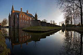
Zuylen Castle is a Dutch castle at the village of Oud-Zuilen just north of the city of Utrecht. It is located along the river Vecht at the southern end of the Vechtstreek.

Dutch Block Political party in the Netherlands

The Dutch Block was a Dutch nationalist political party espousing an anti-immigrant program. It was founded by Alfred Vierling, Ton Steemers en Hans Lindenburg, modeled on the Flemish Block and later taken over by Wim Vreeswijk, who became council member in Utrecht.

Elisabeth Cornelia Alphonsa Maria (Elise) Boot is a Dutch jurist and former politician.

ASR Nederland

ASR Nederland is a major Dutch insurance group based in Utrecht. The company was created in its current form in 2008 when the insurance business was split out of Fortis, after it was acquired by the Dutch government during the Financial crisis of 2007-2010. The Dutch government revived the old name that had been used prior to the acquisition by Fortis in 2000 for the newly structured company.

European route E311 Road in trans-European E-road network

E 311 is a European B class road in Netherlands, connecting the cities of Utrecht and Breda.

Volt Netherlands Dutch political party

Volt Netherlands is a social-liberal political party in the Netherlands. It is the Dutch branch of Volt Europa, a political movement that operates on a European level.

References

Unless another source is given, the settlement is shown in the topographical atlas.