Vianen is a city and a former municipality in the central Netherlands, in the province of Utrecht. It is located south of the Lek River. Before 2002 it was part of the province of South Holland. Vianen is made up of a historic town centre that dates back to the medieval period and was once surrounded by a defensive wall and moat, as well as more extensive modern housing developments to the east, south and southwest and an industrial and commercial area. Vianen is intersected by two major motorways leading to Utrecht: the A2 (Amsterdam-Maastricht) and the A27 (Breda-Almere). Both roads can be notoriously congested near Vianen during peak commute hours. The municipality was merged with the municipalities of Leerdam and Zederik on 1 January 2019. The name of the new municipality is Vijfheerenlanden which is a part of the province Utrecht.

Hagestein is a village and former city in the municipality of Vijfheerenlanden, Utrecht, Netherlands, on the Lek River, about 2 km east of Vianen. It received city rights in 1382. Hagestein was destroyed in 1405 by the Count of Holland and the Prince-Bishop of Utrecht.

Peize is a village in the Dutch province of Drenthe. Located in the northern part of Drenthe approximately 10 kilometers south of the city of Groningen. It is part of the municipality of Noordenveld, located between Roden and Eelde.

Numansdorp is a town and former municipality in the province South Holland in the Netherlands and is located on the island Hoeksche Waard near the Hollands Diep. On 1 January 1984, the municipalities Numansdorp and Klaaswaal were merged into one municipality called Cromstrijen. Cromstrijen was merged into the new municipality Hoeksche Waard in January 2019.

Hekendorp is a village in the Dutch province of Utrecht. It is a part of the municipality of Oudewater, and lies about 6 km east of Gouda.
Hoek is a village in the Dutch province of Zeeland. It is a part of the municipality of Terneuzen, and lies about 22 km south-east of Vlissingen.

Lexmond is a village in the Dutch province of Utrecht. It is a part of the municipality of Vijfheerenlanden, and lies about 7 km south of IJsselstein.

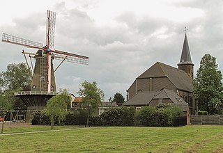
Tienhoven is a village in the Dutch province of Utrecht. It is a part of the municipality of Vijfheerenlanden, and lies about 10 km southwest of IJsselstein.

Zuid-Beijerland is a village in the Dutch province of South Holland. It is a part of the municipality of Hoeksche Waard, and lies about 10 km south of Spijkenisse.

Spijk is a village in the Dutch province of Gelderland. It is a part of the municipality of West Betuwe, about 3 km northeast of Gorinchem.

Herwijnen is a village in the Dutch province of Gelderland. It is a part of the municipality of West Betuwe, and lies about 11 km east of Gorinchem.

Waardenburg is a village in the Dutch province of Gelderland. It is a part of the municipality of West Betuwe, and is located about 13 km west of Tiel.

Varik is a village in the Dutch province of Gelderland. It is a part of the municipality of West Betuwe, and lies about 8 km south of Tiel.

Kuinre is a village in the Dutch province of Overijssel. It was a separate municipality until 1973, when it became a part of IJsselham, which in turn merged into the municipality of Steenwijkerland in 2001.

Dalem is a village in the Dutch province of South Holland. It is located in the municipality of Gorinchem, about 2 km east of the city.

Vijfheerenlanden, literally "lands of five Lords", is a municipality in the province of Utrecht in the Netherlands. The municipality was created on 1 January 2019 through the merger of the former municipalities of Vianen (Utrecht), Leerdam and Zederik. Vijfheerenlanden has 59,150 inhabitants on 1 January 2022.

Hedikhuizen is a village in the Dutch province of North Brabant. It is located in the municipality of Heusden, about 3 km east of that city.

Nieuwenhoorn is a village in the Dutch province of South Holland. It is located in the municipality of Voorne aan Zee, about 3 km north of Hellevoetsluis city centre.

Schoonrewoerd is a village in the Dutch province of Utrecht. It is a part of the municipality of Vijfheerenlanden, and lies about 25 km south of the city of Utrecht. Leerdammer cheese is produced in Schoonrewoerd.

Westmaas is a village in the Dutch province of South Holland. It is located about 14 km south of the city of Rotterdam, next to Mijnsheerenland in the municipality of Hoeksche Waard. In 2020, the population was 2065.