
Congleton is a market town and civil parish in the unitary authority of Cheshire East in Cheshire, England. It is on the River Dane, 21 miles (34 km) south of Manchester and 13 miles (21 km) north of Stoke on Trent. At the 2021 census, it had a population of 30,015.
Stoke-on-Trent is a city and unitary authority area in Staffordshire, England, with an area of 36 square miles (93 km2). In 2022, the city had an estimated population of 259,965. It is the largest settlement in Staffordshire and is surrounded by the towns of Newcastle-under-Lyme, Alsager, Kidsgrove and Biddulph, which form a conurbation around the city.

Alsager is a town and civil parish in the unitary authority of Cheshire East in Cheshire, England. It is located to the north-west of Stoke-on-Trent and east of Crewe. The town's population was 13,389 at the 2021 census.

Biddulph is a town in Staffordshire, England, 8.5 miles (14 km) north of Stoke-on-Trent and 4.5 miles (7 km) south-east of Congleton, Cheshire.

Congleton was, from 1974 to 2009, a local government district with borough status in Cheshire, England. It included the towns of Congleton, Alsager, Middlewich and Sandbach. The headquarters of the borough council were located in Sandbach.

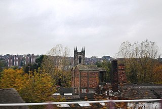
Congleton railway station is a mainline station serving the Cheshire market town of Congleton. It lies on the Stafford-Manchester branch of the West Coast Main Line in the United Kingdom.

Delamere Forest is a large wood in the village of Delamere in Cheshire, England. The woodland, which is managed by Forestry England, covers an area of 972 hectares making it the largest area of woodland in the county. It contains a mixture of deciduous and evergreen trees.
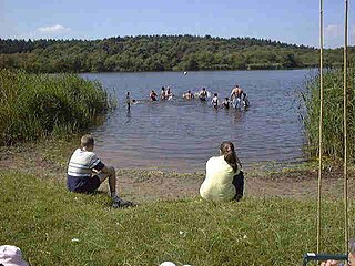
West Heath is a suburb to the west of Congleton, in Cheshire, England. It is the site of Astbury Mere Country Park. The West Heath area has three schools, with one of Congleton's two secondary schools, Congleton High School being located there.

Mow Cop is a village split between Cheshire and Staffordshire, and therefore divided between the North West and West Midlands regions of England. It is 24 miles (39 km) south of Manchester and 6 miles (9.7 km) north of Stoke-on-Trent, on a steep hill of the same name rising to 335 metres (1,099 ft) above sea level. The village is at the edge of the southern Pennines, with the Cheshire Plain directly to the west. For population details taken at the 2011 census, see Kidsgrove. The Cheshire section is the highest settlement within the county of Cheshire.
Sideway is an area of Stoke-on-Trent, approximately one mile south west of Stoke-upon-Trent, Stoke-on-Trent, in Staffordshire, England. It is located on the junction of the A500 and the A50 adjacent to the Bet365 Stadium.

Church Lawton is a village and civil parish in the unitary authority area of Cheshire East and in the ceremonial county of Cheshire in England. Its eastern boundary forms part of the county boundary between Cheshire and Staffordshire. As the village is near Stoke-on-Trent, it has a Stoke postcode. In addition to ribbon development connecting Kidsgrove with Scholar Green, the parish also contains the hamlets of Lawton Gate, Lawton Heath and Lawton Heath End, and the Lawton Hall estate. According to the 2001 census, the population of the entire parish was 2,201.
Brereton is a civil parish in Cheshire, England. At the 2011 census, the population was 1,190. Brereton is mentioned in the Domesday book as the Manor of Bretune. The civil parish includes the hamlets of Brereton Green, Brereton Heath, Smethwick Green, Medhurst Green, Sandlow Green and Davenport.

Cheshire East is a unitary authority area with borough status in Cheshire, England. The local authority is Cheshire East Council, which is based in the town of Sandbach. Other towns within the area include Crewe, Macclesfield, Congleton, Wilmslow, Nantwich, Poynton, Knutsford, Alsager, Bollington and Handforth.
Hatchmere is a small mere and nature reserve in Delamere Forest, southeast of Frodsham, Cheshire, England. It is also the name of a hamlet near the village of Norley.

Tegg's Nose is a hill east of Macclesfield in Cheshire, England. It has a short ridge with a high point of 380 metres (1,250 ft) at SJ947725, terminating in a promontory at the southern end. It lies on the western edge of the Peak District, although outside the boundary of the national park. Much of the hill's area falls within the Tegg's Nose Country Park, managed by Cheshire East Council Countryside Management Service; Tegg's Nose is also part of the Environmentally Sensitive Area Scheme.

The Stoke-on-Trent Green Belt is a green belt environmental and planning policy that regulates the rural space throughout mainly the West Midlands region of England. It is contained within the counties of Cheshire and Staffordshire. Essentially, the function of the designated area is to prevent surrounding towns and villages within the Stoke-on-Trent conurbation from further convergence. It is managed by local planning authorities on guidance from central government.
The Biddulph Valley line was a double tracked line that ran from Stoke-on-Trent to Brunswick Wharf in Congleton. The line was named after the town of the same name as it ran via the Staffordshire Moorlands and covered areas of East Staffordshire and Cheshire.

Shakerley Mere is a lake and recreation area near Allostock, Cheshire, England. The mere is a former sand quarry, which flooded after extraction ended in the 1960s. Roughly triangular in shape, it bounded to the east by the M6 motorway and on the other two sides by the B5081 and B5082 roads. The site is managed for recreation by Cheshire West and Chester Council. There is a small amount of heathland, a designated site of biological importance, in the southeast corner, and a circular path runs around the perimeter of the lake, a distance of 0.9 miles (1.4 km).

Mere Sands Wood is a 105 acres (42 ha) nature reserve between the villages of Holmeswood and Rufford in west Lancashire, England, managed by The Wildlife Trust for Lancashire, Manchester & North Merseyside. It lies about five miles from Ormskirk. The name derives from when the area was on the shore of Martin Mere.

