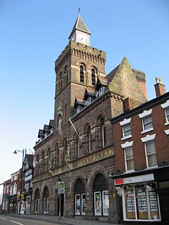
Congleton is a town and civil parish in Cheshire, England, on the River Dane, 21 miles (34 km) south of Manchester and west of the Macclesfield Canal. At the 2011 Census, it had a population of 26,482.

Congleton was, from 1974 to 2009, a local government district with borough status in Cheshire, England. It included the towns of Congleton, Alsager, Middlewich and Sandbach. The headquarters of the borough council were located in Sandbach.

Mousehold Heath is a freely accessible area of heathland and woodland which lies to the north-east of the medieval city boundary of Norwich, in eastern England.

Congleton is a parliamentary constituency in Cheshire, represented in the House of Commons of the UK Parliament since 2010 by Fiona Bruce of the Conservative Party.

Delamere Forest is a large wood in the village of Delamere in Cheshire, England. The woodland, which is managed by the Forestry England, covers an area of 972 hectares making it the largest area of woodland in the county. It contains a mixture of deciduous and evergreen trees.

Bickerton Hill refers to two low red sandstone hills that form the southern end of the Mid Cheshire Ridge in Cheshire, north-west England. The high point, Raw Head, lies on the northerly hill and has an elevation of 227 metres. Parts of the southerly hill are also known as Larkton Hill.
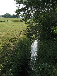
The River Croco is a small river in Cheshire in England. It starts as lowland field drainage west of Congleton, flows along the south edge of Holmes Chapel, and joins the River Dane at Middlewich. It is about 8 miles (13 km) long.

Norbury is a hamlet and civil parish in the unitary authority of Cheshire East and the ceremonial county of Cheshire, England. The parish lies on the boundary with Cheshire West and Chester, and also includes the small settlements of Gauntons Bank, Hurst Green, Swanwick Green, Norbury Common and Holtridge, with a total population of nearly 200 people in 2011. The hamlet of Norbury lies around 5 miles (8 km) north of Whitchurch in Shropshire. Nearby villages include No Man's Heath, Marbury and Wrenbury.

Bradwall is a small village and civil parish in the unitary authority of Cheshire East, about 2 mi (3.2 km) northwest of Sandbach in the ceremonial county of Cheshire, England, and about 20 mi (32 km) south of Manchester. According to the 2011 census, the population of the entire parish was 182. The area is predominantly agricultural, with no manufacturing or retail outlets.

Chorlton is a village and civil parish in the unitary authority of Cheshire East and the ceremonial county of Cheshire, England. The village lies 4 miles (6.4 km) to the south east of Crewe. Nearby villages include Hough, Shavington, Weston and Wybunbury in Cheshire and Betley in Staffordshire. The population was nearly 900 people in 2011.

Broadmoor to Bagshot Woods and Heaths is a 1,696.3-hectare (4,192-acre) biological Site of Special Scientific Interest (SSSI) in Berkshire and Surrey that extend from a minority of the parish of Crowthorne including around Broadmoor Hospital in the west to Bagshot south-east, Bracknell north-east, and Sandhurst, south. It is part of the Thames Basin Heaths Special Protection Area. Two nature reserves which are managed by the Surrey Wildlife Trust are in the SSSI, Barossa nature reserve and Poors Allotment. Broadmoor Bottom, which is part of Wildmoor Heath, also falls within the SSSI; this reserve is managed by the Berkshire, Buckinghamshire and Oxfordshire Wildlife Trust.

Tegg's Nose is a hill east of Macclesfield in Cheshire, England. It has a short ridge with a high point of 380 metres (1246 feet) at SJ947725, terminating in a promontory at the southern end. It lies on the western edge of the Peak District, although outside the boundary of the national park. Much of the hill's area falls within the Tegg's Nose Country Park, managed by Cheshire East Council Countryside Management Service; Tegg's Nose is also part of the Environmentally Sensitive Area Scheme.

Northwich Woodlands is an area of 373 hectares of publicly accessible countryside near Northwich in Cheshire, England. It comprises nine separate woods, country parks, lakes and parks, many of which are connected to each other via footpaths and other rights of way. Much of the land was formerly industrial and used for mining salt and manufacturing chemicals. The extraction of salt caused subsidence leading to the formation of pools known as flashes. The land became derelict during the 20th century as the salt industry contracted. Much of the area has now been reclaimed for the purposes of conservation and recreation and forms part of the Mersey Forest initiative.
Sound Heath, also known as Sound Common, is an area of common land in Sound, near Nantwich in Cheshire, England, which includes heathland, grassland, scrub, woodland and wetland habitats. The majority of the area is designated a Site of Special Scientific Interest and a Local Nature Reserve.

The North Cheshire Way is a 71-mile (114 km) long-distance footpath in Cheshire, England. It runs approximately eastwards from Hooton railway station on the Wirral peninsula to Disley railway station on the edge of the Peak District, where it connects with the Gritstone Trail. There is a 6-mile (9.7 km) spur from Chester to Croughton.

Shakerley Mere is a lake and recreation area near Allostock, Cheshire, England. The mere is a former sand quarry, which flooded after extraction ended in the 1960s. Roughly triangular in shape, it bounded to the east by the M6 motorway and on the other two sides by the B5081 and B5082 roads. The site is managed for recreation by Cheshire West and Chester Council. There is a small amount of heathland, a designated site of biological importance, in the southeast corner, and a circular path runs around the perimeter of the lake, a distance of 0.9 miles (1.4 km).

Astbury Mere is a lake and open area in West Heath, a suburb of Congleton, Cheshire, England, in an area formerly quarried for silica sand. Part of the area is accredited by Natural England as a country park, Astbury Mere Country Park. The country park has an area of 14 hectares and the lake covers 43 acres (17 ha). The park is owned by Astbury Mere Trust, and the lake and its banks by Stoke-on-Trent Angling Society.
