
Anston is a civil parish in South Yorkshire, England, formally known as North and South Anston. The parish of Anston consists of the settlements of North Anston and South Anston, divided by the Anston Brook.
Aston Sandford is a small village and civil parish in the Aylesbury Vale district of Buckinghamshire, England, about 1 mile (1.6 km) east of Haddenham and 4 miles (6.4 km) northwest of Princes Risborough. It is in the civil parish of Kingsey.

Firbeck is a village and civil parish in the Metropolitan Borough of Rotherham in South Yorkshire, England, on the border with Nottinghamshire. It lies between Maltby and Oldcotes, off the A634 and B6463 roads. Firbeck had a population of 317 in 2001, which had fallen to 299 at the 2011 Census.

Maltby is a former mining town and civil parish of 16,688 inhabitants (2011) in the Metropolitan Borough of Rotherham, South Yorkshire, England. It was historically in the West Riding of Yorkshire. It is located about 6 miles (10 km) east of Rotherham town centre and 10 miles (16 km) north-east of Sheffield city centre. It forms a continuous urban area with Hellaby, separated from the rest of Rotherham by the M18 motorway.

Beighton —which includes the districts of Beighton, Hackenthorpe, Owlthorpe, and Sothall—is one of the 28 electoral wards in City of Sheffield, England. It is located in the eastern part of the city, on the border with Rotherham and covers an area of 5.7 km2. The population of this ward in 2011 was 17,939 people in 7,538 households.

Healing is a village and civil parish in North East Lincolnshire, England. It is situated between Stallingborough and Great Coates, and 3 miles (5 km) west from Grimsby.

Gleadless is a suburb and parish within the City of Sheffield, it lies five km south east of the city centre. It is bordered by the adjoining suburbs of Gleadless Valley to the west, Frecheville to the east and Intake to the north. The land to the south is the rural area of North East Derbyshire district which is outside the city boundary. Gleadless was formerly a country hamlet, then village before becoming part of the expanding city of Sheffield in 1921. The word Gleadless comes from the Old English language and means either “forest clearings haunted by a kite” or “bright clearing”.

Barrowby is a village and civil parish in the South Kesteven district of Lincolnshire, England. It is 2 miles (3.2 km) west of Grantham town centre in a position overlooking the Vale of Belvoir. It has a Grade I listed parish church. The hamlet of Casthorpe is part of the parish. The 2001 Census listed 795 households and a population of 1,996, which fell to 840 households with 1,952 inhabitants at the 2011 census. It was estimated at 1,986 in 2019.

Harworth is an area in the civil parish of Harworth Bircotes in the Bassetlaw district in Nottinghamshire, England. It is approximately 8 miles (13 km) north of Worksop. The population of the civil parish was 7,948 in the 2011 Census. The Harworth coal mine opened in 1921 and produced coal for the power stations on the River Trent. A new pit tower was built in 1989 when the pit was at its peak of production but seven years later the colliery was 'mothballed'. In 2015, it was announced that the pit tower would be demolished and the colliery site would be redeveloped for housing which has since been completed. The former freight line and sidings into the colliery have been lifted and left undeveloped. The local football team is called Harworth Colliery F.C..
Ulley is a village and civil parish of the Metropolitan Borough of Rotherham in South Yorkshire, England. The population of the civil parish as of the 2011 census was 172. It is located about 4 miles (6 km) south of the town of Rotherham and 7 miles (11 km) east of Sheffield City Centre.

Aston Academy is a secondary school with academy status at Swallownest in the Metropolitan Borough of Rotherham, South Yorkshire, England.

Aston is a residential village in the Metropolitan Borough of Rotherham, South Yorkshire, England. The village falls within the Holderness ward of the borough. Aston is approximately 2 miles (3 km) from Rother Valley Country Park.

Aughton is a village near Rotherham in South Yorkshire, England, located in the civil parish of Aston cum Aughton, 4 miles (6 km) south of Rotherham. The village setting is rural, being surrounded by fields. The nearest settlements are Guilthwaite in the north, Ulley in the east, Aston in the southeast, Swallownest in the south, and Treeton in the northwest. Major roads are A618 running north–south and B6067 running northwest–southeast which cross in the northern part of the village and share a common alignment along the northern 300 yards (270 m) of Main Street.
Aston Colliery was a small coal mine sunk on Aston Common, within Rotherham Rural District but six miles east of Sheffield in the 1840s. In 1864 its workings were taken over and developed by the North Staveley Colliery Company, part of the Staveley Coal and Iron Company, based in North Derbyshire. It was later acquired by the Sheffield Coal Company.

Manthorpe is a village in the South Kesteven district of Lincolnshire, England. It is on the northern edge of the town of Grantham and on the Grantham to Lincoln A607 road, between the East Coast Main Line and the River Witham. The village is part of the civil parish of Belton and Manthorpe.

Swallownest is a village in the civil parish of Aston cum Aughton and the Metropolitan Borough of Rotherham, South Yorkshire, England. The village is 4 miles (6.4 km) south of Rotherham and 7 miles (11 km) from Sheffield.
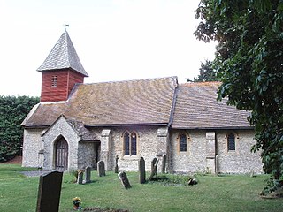
The Church of All Saints is the parish church of Aston cum Aughton in South Yorkshire, England. It is a Church of England church in the Diocese of Sheffield. The building is a Grade I listed building and dates back the 12th century.

Swallownest F.C. is an English football club based in Swallownest, Rotherham, South Yorkshire. They are currently members of the Northern Counties East League Division One.

Aston Hall is a former English country house in the village of Aston, South Yorkshire. It is now a hotel, and a Grade II* listed building.
Aston cum Aughton is a civil parish in the Metropolitan Borough of Rotherham, South Yorkshire, England. The parish contains 25 listed buildings that are recorded in the National Heritage List for England. Of these, one is listed at Grade I, the highest of the three grades, one is at Grade II*, the middle grade, and the others are at Grade II, the lowest grade. The parish contains the villages of Aston, Aughton and Swallownest and the surrounding countryside. Most of the listed buildings are houses and associated structures, farmhouses and farm buildings. The other listed buildings include a church, associated gate piers and a gravestone, a former school used as a reading room, and two mileposts.