
Karabük Province is a landlocked province in the northern part of Anatolia, located about 200 km (124 mi) north of Ankara, 115 km (71 mi) away from Zonguldak and 113 km (70 mi) away from Kastamonu. In 2010 it had a population of 227,610. The main city is Karabük which is located about 100 km (62 mi) south of the Black Sea coast.
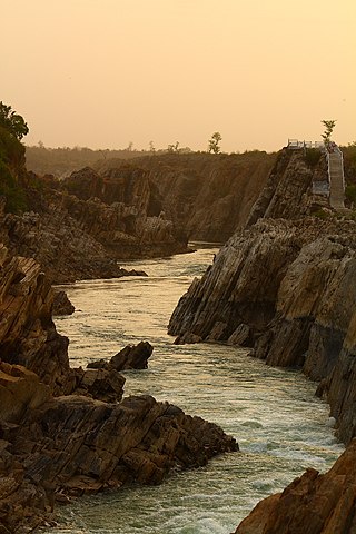
The Narmada River, also called the Reva and previously also known as Narbada or anglicised as Nerbudda, is the 5th longest river and overall longest west-flowing river in India. It is also the largest flowing river in the state of Madhya Pradesh. This river flows through the states of Madhya Pradesh and Gujarat in India. It is also known as the "Life Line of Madhya Pradesh and Gujarat" due to its huge contribution to the two states in many ways. The Narmada River rises from the Amarkantak Plateau in Anuppur district Madhya Pradesh. It forms the traditional boundary between North India and South India and flows westwards over a length of 1,312 km (815.2 mi) before draining through the Gulf of Khambhat into the Arabian Sea, 30 km (18.6 mi) west of Bharuch city of Gujarat.

Chamberlain is a village in the Canadian province of Saskatchewan within the Rural Municipality of Sarnia No. 221 and Census Division No. 6.

The Noyyal River is a small river in Western Tamil Nadu, and a tributary of Kaveri River. It rises from the Vellingiri hills in the Western Ghats in Tamil Nadu, very closer in proximity to Kerala border, and flows through many villages and the cities of Coimbatore, and Tirupur. Then finally, the river drains into the Kaveri River at Noyyal, a village in Karur district named after the river itself. The river's basin is 180 km (110 mi) long and 25 km (16 mi) wide and covers a total area of 3,500 km2 (1,400 sq mi). Cultivated land in the basin amounts to 1,800 km2 (690 sq mi) while the population density is 120 people per km² (311/mi²) in the countryside, and 1000 people per km² (2590/mi²) in the cities. The area is known for its scanty rainfall and the development of the Noyyal River Tanks System to hold any overflow from the rains plus the water of the Northeast and Southwest monsoon season was ecologically important. Kausika river, which originates along the northern side of Coimbatore district in the Western Ghats along with its consequent streams, lake and pond systems is an important tributory of the river. The 173 km (107 mi) long tributary of the Kaveri River filled 32 tanks. These interconnecting tanks held the water flowing from the Noyyal.

Manali is a town, near Kullu town in Kullu district in the Indian state of Himachal Pradesh. It is situated in the northern end of the Kullu Valley, formed by the Beas River. The town is located in the Kullu district, approximately 270 kilometres (170 mi) north of the state capital of Shimla and 544 kilometres (338 mi) northeast of the national capital of New Delhi. With a population of 8,096 people recorded in the 2011 Indian census Manali is the beginning of an ancient trade route through Lahaul (H.P) and Ladakh, over the Karakoram Pass and onto Yarkand and Hotan in the Tarim Basin of China. Manali is a popular tourist destination in India and serves as the gateway to the Lahaul and Spiti district as well as the city of Leh in Ladakh.

The Tungabhadra River is a river in India that starts and flows through the state of Karnataka during most of its course, before flowing along the border between Telangana, Andhra Pradesh and ultimately joining the Krishna River near Gundimalla village in Jogulamba Gadwal district of Telangana.

The N21 road is a national primary road in Ireland. The route runs from the M20 outside Limerick to Tralee with connecting roads to other parts of County Kerry. It is 84.37 km (52.43 mi) in length. It runs through the towns of Abbeyfeale, Newcastle West, Adare and the village of Templeglantine. Prior to October 2010 the N21 also ran through the town of Castleisland. The town has since been bypassed. Rathkeale was also bypassed in 1992.
Gülnar is a district of Mersin Province of Turkey, 150 km (93 mi) south-west of the city of Mersin.

Mankada is a hillside village in the Malappuram district of Kerala state. It is located 15 km (9.3 mi) from Malappuram and is part of the Malappuram parliament constituency. The municipal town of Perinthalmanna is just 10 km (6.2 mi) away. Also, the municipal towns of Manjeri and Malappuram are just 15 km (9.3 mi) away. Mankada Kadannamanna Kovilakam was the seat of ruling family of the erstwhile Kingdom of Valluvanad.
La Clusaz is a commune in the Haute-Savoie department in the Auvergne-Rhône-Alpes region in south-eastern France.
The R755 road is a regional road in Ireland. It runs for its entire length in County Wicklow. From the village of Kilmacanogue on the N11 national primary road it goes north/south for 36 km (22 mi) to the town of Rathdrum.

Keerampara is an Indian village in the state of Kerala, India. This is a junction. This place is once blessed with the footprints of all the holy personnel who passed through the Royal route.

Tromborn is a commune in the Moselle department in Grand Est in north-eastern France.

Manathana is a village in Peravoor Grama Panchayat of Kannur district, Kerala, India.
Federal Highway 36 is a free part of the federal highways corridors of Mexico. The highway construction is entirely within the state of Durango. The official start of the highway indicates it begins in the city of Topia then runs eastward to the town of Los Herrera. However, the paved and graded portion of the road does not go to Topia. Along the graded and paved road at a point about 96 km (60 mi) from Santiago de Papasquiaro a narrow and ungraded road leads off of Fed. 36 and extends 28 km (17 mi) to Topia, Durango. The road from Fed. 36 to Topia is a narrow dirt road. The paved and graded road system continues past that intersection and has been extended year by year in a westward direction to the crest of the Sierra Madre Occidental and down the western slope of the Sierras, following the drainage of the Topia River, past Canales, Durango and then on to the end of construction in a dead end about 24 km. beyond Canales at the remote village of La Angostura. This village just happens to be the home of Ines Coronel Barreras, a cattle rancher and Sinaloa drug lord, who is the father of Emma Coronel Aispuro, the Mexican beauty queen and wife of the internationally notorious drug lord Joaquin "El Chapo" Guzman, currently indicted and in jail in the United States for drug related crimes. This terminus of the graded and paved road is only 32 km (20 mi) by direct line from Tamazula de Victoria, Durango. It is unknown whether there will be further road construction beyond La Angostura to Tamazula de Victoria in the coming years though that would be feasible from an engineering standpoint. Until the completion of the highway construction an alternative route which is ungraded branches off the paved road on the crest of the mountains and continues on to highways in the state of Sinaloa. Those routes are all noted below.
Turan is a small village in Phillaur tehsil of Jalandhar District of Punjab State, India. It is located 1 km (0.62 mi) away from the Apra-Banga road and 11 km (6.8 mi) away from the postal head office at Dosanjh Kalan. The village is 3 km (1.9 mi) away from the census town Apra, 16 km (9.9 mi) from Phillaur, 42 km (26 mi) from Jalandhar, and 120 km (75 mi) from the state capital Chandigarh. The village is administrated by Sarpanch who is elected representative of village.
Ratainda or Ratenda is a large village in Shaheed Bhagat Singh Nagar district of Punjab State, India. The village is administrated by a Sarpanch, who is the elected representative of the village. It is located 2.5 km (1.6 mi) from postal head office Moron, 6.3 km (3.9 mi) from census town Apra, 11.7 km (7.3 mi) from Shaheed Bhagat Singh Nagar and 113 km (70 mi) from Chandigarh.
Ladian or Ladhian is a village in Phillaur tehsil of Jalandhar District of Punjab State, India. It is located 36 km (22 mi) from postal head office Dosanjh Kalan, 9.8 km (6.1 mi) from Ludhiana, 53.4 km (33.2 mi) from Jalandhar and 108 km (67 mi) from state capital Chandigarh. The village is administrated by a Sarpanch, an elected representative of the village.

National Highway 505, commonly called NH 505, is a national highway in India. It is a spur road of National Highway 5. NH-505 traverses the state of Himachal Pradesh in India. NH505 a high elevation road, covers Kinnaur and Lahaul and Spiti districts of Himachal Pradesh, mainly running along Spiti river in Spiti valley. The highway from Kaza to Gramphu remains closed for 6–9 months in a year due to heavy snowfall and closure of Kunzum La pass at an elevation of 4,550 m (14,930 ft).

