
Kruger National Park is a South African National Park and one of the largest game reserves in Africa. It covers an area of 19,623 km2 (7,576 sq mi) in the provinces of Limpopo and Mpumalanga in northeastern South Africa, and extends 360 km (220 mi) from north to south and 65 km (40 mi) from east to west. The administrative headquarters are in Skukuza. Areas of the park were first protected by the government of the South African Republic in 1898, and it became South Africa's first national park in 1926.

Mpumalanga is one of the nine provinces of South Africa. The name means "East", or literally "The Place Where the Sun Rises" in the Nguni languages. Mpumalanga lies in eastern South Africa, bordering Eswatini and Mozambique. It shares borders with the South African provinces of Limpopo to the north, Gauteng to the west, the Free State to the southwest, and KwaZulu-Natal to the south. The capital is Mbombela.

Limpopo is the northernmost province of South Africa. It is named after the Limpopo River, which forms the province's western and northern borders. The term Limpopo is derived from Rivombo (Livombo/Lebombo), a group of Tsonga settlers led by Hosi Rivombo who settled in the mountainous vicinity and named the area after their leader. The Lebombo mountains are also named after them. The river has been called the Vhembe by local Venda communities of the area. The capital and largest city in the province is Polokwane, while the provincial legislature is situated in Lebowakgomo.

Ezemvelo KZN Wildlife is a governmental organisation responsible for maintaining wildlife conservation areas and biodiversity in KwaZulu-Natal Province, South Africa. Their headquarters is in Queen Elizabeth Park situated on the northern slopes of Pietermaritzburg, the KwaZulu-Natal provincial capital. Prior to 1994, it was known as the Natal Parks Board.

James Stevenson-Hamilton served from 1902–1946 as the first warden of South Africa's Sabi Nature Reserve, which was expanded under his watch and became Kruger National Park in 1926. The Tsonga people nicknamed him Skukuza because when he arrived at the area of the reserve he "turned everything upside down" with the banning of all hunting in the reserve and the relocation of all the native kraals. Skukuza camp and Skukuza Airport is named in honour of Stevenson-Hamilton, who is regarded as a champion of wildlife Conservation in South Africa.

Great Limpopo Transfrontier Park is a 35,000 km2 peace park that is in the process of being formed. It will link the Limpopo National Park in Mozambique, Kruger National Park in South Africa, Gonarezhou National Park, Manjinji Pan Sanctuary and Malipati Safari Area in Zimbabwe, as well as the area between Kruger and Gonarezhou, the Sengwe communal land in Zimbabwe and the Makuleke region in South Africa.
Malalane, alternatively rendered Malelane, is a farming town in Mpumalanga, South Africa situated on the N4 national highway. The farms in the region produce sugarcane, subtropical fruit and winter vegetables. The town was proclaimed in 1949 after which it was named. The origin of the name is disputed but was corrupted from the Swazi. Either the expression "eMlalani" which means place of the palms, or the expression "lala" which means to sleep is accepted origins of the name. The town started as the first rest-stop between Lourenço Marques and Pretoria. As of July 2007 the town was officially renamed from "Malelane" to "Malalane" as part of the government's renaming scheme by the South African Geographical Names Council.

Hoedspruit is a town situated at the foot of the Klein Drakensberg, in the Limpopo province of South Africa, on the railway line from Tzaneen to Kaapmuiden.

The Pilanesberg National Park is located north of Rustenburg in the North West Province of South Africa. The park borders on the Sun City entertainment complex. It is administered by the North West Parks and Tourism Board.

The Tuli Block is a narrow fringe of land at Botswana's eastern border wedged between Zimbabwe in the north and east and South Africa in the south. It consists mainly of privately owned game farms offering safari tourism. The eastern section up to and including Redshield has been declared a game reserve, known as the Northern Tuli Game Reserve.

Balule Nature Reserve is a protected area in Limpopo Province, South Africa which forms part of the Greater Kruger National Park as a member of the Associated Private Nature Reserves (APNR). As part of a wildlife conservation initiative, all fences separating APNR reserves – Balule, Timbavati, Klaserie, Umbabat, – and the Kruger National Park have been removed.

Mabalingwe , is located 28 km west of Bela Bela, in the Limpopo province of South Africa, and is about 8 800 hectare in area. It is in an easily accessible, malaria-free area of the Transvaal bushveld, around an hour-and-a-half drive from Johannesburg.
Letaba Ranch Provincial Park, is a protected area in Limpopo Province, South Africa. It is located north of Phalaborwa, next to the Kruger Park, and has an area of about 42,000 ha. The Great Letaba River, runs through the park.

Londolozi Private Game Reserve is a large game reserve, with 15 000 hectares ; 42 000 acres; 58 sq mi) of land in northeastern South Africa. This means 1 bed per 167 hectares of land. Londolozi Rangers are not bound by Kruger Park rules and can therefore drive off-road on safari and conduct comprehensive bush walks into the wilderness. The reserve is part of the Sabi Sand Private Game Reserve, situated on the western border of Kruger National Park, which together with some other parks make up the Great Limpopo Transfrontier Park. Londolozi is a Zulu word meaning "Protector of all Living Things". Wildlife in this reserve includes the Big Five of Africa.
The Kruger National Park is a South African National Park and one of the largest game reserves in Africa. Originally known as The Sabi Game Reserve, it became a game reserve in 1898. The park became known as Kruger National Park in 1926, when it was named after Paul Kruger.

Shingwedzi is a rest camp and ranger's post situated in the northern section of the Kruger National Park. The camp is located on the southern bank of the Shingwedzi River, for which it is named, in Limpopo province, South Africa. The surrounding country formerly constituted the Singwitsi Reserve, proclaimed in 1903, which encompassed over 5,000 square kilometers. The region was over-hunted by the end of the 19th century, its big game depleted and its elephant population completely decimated. The name "Shingwedzi" is of Tsonga origin, and was perhaps derived from "Shing-xa-goli", perhaps a local chieftain, and "njwetse", the sound of iron rubbing against iron.
Schoemansdal was a settlement situated 16 km west of Louis Trichardt (Makhado), which had its origins during the Great Trek. It existed from 1848 to 1867, and functioned as the capital of an autonomous region until the S.A.R. Volksraad was established, when the outpost came under the supervision and regulations of the central government. The settlement was evacuated after only thirty years when attacked by Venda militants. The government rendered indecisive support and the town as torched by Katze-Katze on the night of 15 July 1867.
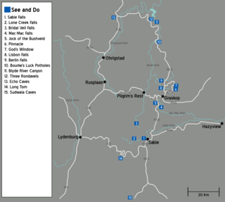
The Panorama Route is a scenic road in South Africa connecting several cultural and natural points of interest. The route, steeped in the history of South Africa, is in Mpumalanga province, centred around the Blyde River Canyon, the world's third largest canyon. It features numerous waterfalls, one of the largest afforested areas in South Africa, and several natural landmarks. The route starts at the foot of the Long Tom Pass just outside Lydenburg, following the natural descent from the Great Escarpment to the Lowveld, and ending at the border of the Mpumalanga and Limpopo provinces near the Echo Caves.

Philip Herd Nature Reserve is a nature reserve within the UNESCO Vhembe Biosphere Reserve in the Vhembe District of Limpopo Province, South Africa. The reserve is located east of the town of Musina on the Limpopo River which forms the border between South Africa and Zimbabwe. It covers an area of 12,000 hectares (Ha), of which 6,616.42 Ha is a declared protected area in terms of South Africa's National Environmental Management Act: Protected Areas Act of 2003. The reserve conserves a critically biodiverse area of Limpopo Ridge Bushveld and 1.5% of the Nzhelele River catchment, which forms part of the Limpopo Water Management Area (WMA) established in terms of South Africa's National Water Act of 1998. The reserve operates under the brand name, The Herd Reserve.
