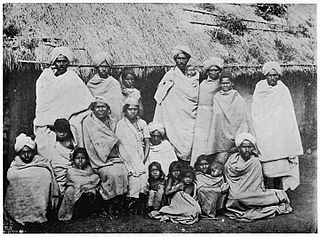
The Badagas are an ethno-linguistic community living in the Nilgiri district in Tamil Nadu, India. Throughout the district the Badugas live in nearly 400 villages, called Hattis.The Badagas speak a language called Badaga.

Ooty, officially known as Udagamandalam, is a town and a municipality in the Nilgiris district of the Indian state of Tamil Nadu. It is located 86 km north of Coimbatore and 128 km south of Mysore and is the headquarters of the Nilgiris district. It is a popular hill station located in the Nilgiri Hills. Local residents call it Queen of Hills. It was the summer capital of Madras Presidency.

The Nilgiris district is one of the 38 districts in the southern Indian state of Tamil Nadu. Nilgiri is the name given to a range of mountains spread across the borders among the states of Tamil Nadu, Karnataka and Kerala. The Nilgiri Hills are part of a larger mountain chain known as the Western Ghats. Their highest point is the mountain of Doddabetta, height 2,637 m. The district is contained mainly within the Nilgiri Mountains range. The administrative headquarters is located at Ooty. The district is bounded by Malappuram district of Kerala to the west, Coimbatore and Palakkad to the south, Erode to the east, and Chamarajnagar district of Karnataka and Wayanad district of Kerala to the north. As it is located at the junction of three states namely Tamil Nadu, Kerala, and Karnataka, a significant Malayali and Kannadiga population reside in the district. Nilgiris district is known for natural mines of Gold, which is also seen in the other parts of Nilgiri Biosphere Reserve extended in the neighbouring states of Karnataka and Kerala too.
Badaga is a southern Dravidian language spoken by the Badaga people of the Nilgiris district of Northwest Tamil Nadu. The language is closely related to Kannada.

The Nilgiri Biosphere Reserve is an International Biosphere Reserve in the Western Ghats and Nilgiri Hills ranges of South India. The Nilgiri Sub-Cluster is a part of the Western Ghats, which was declared a World Heritage Site by UNESCO in 2012. It is the largest protected forest area in India, spreading across Tamil Nadu, Karnataka and Kerala. It includes the Aralam, Mudumalai, Mukurthi, Nagarhole, Bandipur and Silent Valley national parks, as well as the Wayanad, Karimpuzha, and Sathyamangalam wildlife sanctuaries.

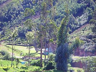
Ketti also called Ketti Valley is a small town nestled in a large valley of the same name. It is located in The Nilgiris District of Tamil Nadu State, South India and is a Revenue Village of Coonoor Taluk. Upper Ketti is another village called Yellanahalli, which is located on the main Coonoor to Ooty road.
Koderi is one among the Badaga Hattis, or hamlets of the Nilgiri hills, located in Tamil Nadu, India, at a distance of 15 km (9.3 mi) from Coonoor and 20 kilometers from Ooty. Koderi is a part of the mekku nadu seeme, one of the four seemes of the Nakku Betta. Koderi itself is divided into two smaller hattis, namely, Mel Koderi and Kil/Kiye Koderi. The nearest picnic spot from Koderi is Kodaparai which is famous for its rock temple in which the rock resembles the shape of an umbrella.
Manihatty is a Badaga village in the Nilgiri District of Tamil Nadu, India. Manihatty is 16 km to the south west of Ooty, the district capital of the Nilgiris.

Bandishola/Vandicholai (Tamil:வண்டிச்சோலை) is a Panchayat village in Coonoor Taluk of The Nilgiris District, Tamil Nadu, India. The settlement takes its name from a nearby Shola. Though the adjective does not feature in the name, this is the Big Bandishola; the Chinna Bandishola is a settlement adjoining Wellington Cantonment. The village gets its name from the conjunction of two Badaga words [bandu+so:le; 'moth+woods'].
Aravenu is a village in Kotagiri Taluk of The Nilgiris District, Tamil Nadu, India. The population is largely Badaga and it is thought to be an original Badaga Hatti. It is the headquarters of the Jackanarai panchayat.
Yedapalli is a Panchayat village in Coonoor Taluk of The Nilgiris District, Tamil Nadu, India.
Kinnakorai is a village in Kundha Taluk, The Nilgiris District, Tamil Nadu. The village consists of about 500 houses and sits about 60 km from Ooty Town and 135 km from Coimbatore city and 60 km from Mulli. The closest town, Manjoor, is 30 km by road.
Yedakadu is a serene hamlet located in the Nilgiris Hills in the state of Tamil Nadu in South India. Yedakadu is located 26 km from Udhagamandalam (Ooty) and 38 km from Coonoor. The major occupation of the people is tea plantation. Yedakadu is popular for its 'Sivarathiri', an annual carnival which draws a large crowd from around the Nilgiris. Badaga is the native language. There are three places within the village named "Naduhatty","Sundatty" & "Thalaihatty".
Tamil Nadu is one of the 28 states of India. Its capital and largest city is Chennai. Tamil Nadu lies in the southernmost part of the Indian Peninsula and is bordered by the States of Puducherry, Kerala, Karnataka and Andhra Pradesh. It is the tenth-largest state in India and the seventh most populous state.
Thangadu Village is a Badaga village in the Nilgiri District of Tamil Nadu, India. Thangadu is 18 km to the south west of Ooty, the district capital of the Nilgiris.
Thanthanadu is a village in Kotagiri Taluk of The Nilgiris District, Tamil Nadu, India. The population is largely Badaga. It is located 2 km from Kotagiri. This village also comprises both the Christians and Hindus. tea is the main plantation for the people over here. Thanthanadu is also known for its pear fruits.
Kundha Hosahutty is a small village which is 30 km far from Ooty, Tamil Nadu, India. It has known to be Kundha Hosahutty because the area around is known as Kundha Semay. Badaga, is a southern Dravidian language spoken by approximately 400,000 people in the Nilgiri Hills of Tamil Nadu. It is known for its retroflex vowels. It has similarities with neighbouring Kannada language and is considered a dialect of Kannada and now claimed as an independent language by a French linguistic scholar, Christiane Pilot-Raichoor. The word Badaga refers to the Badaga language as well as the Badaga indigenous people who speak it.
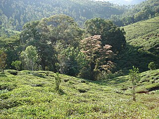
Achanakal is a Badaga village in the Nilgiris district in the Indian state of Tamil Nadu. The village is located adjacent to the Coonoor-Ooty highway in the Ketti valley. The name is believed to be derived from asinikol meaning bamboo sticks in Badaga language which formed the place before the village came into existence. Ketti valley is also considered the second steepest valley in the world. Achanakal is the largest village among the other 13 villages which are located in the valley. The village is just 3 Kilometres away from Ketti and the Lovedale railway stations.
Halatty Manthalatty is a village in the Indian state of Tamil Nadu, under the Nilgiris District. Halatty Manthalatty is also the name given to a range of mountains spread across the states of Tamil Nadu as well as Karnataka and Kerala. It is one of the small villages in Udhagamandalam Taluk in The Nilgiris District under Kadanad Panchayat. Around 100 families and Around 400 people are living in this village.
Mulligoor (முள்ளிகூர்) is a village in the Kundah taluk of Nilgiris District of Tamil Nadu State, India. It is situated 10 kilometers away from sub-district headquarters Kundah and 30 kilometers from district headquarters Ooty. The main cultivation in Mulligoor is tea growing. This area surrounding Mulligoor is also very rich in wildlife.

