The French Quarter, also known as the Vieux Carré, is the oldest neighborhood in the city of New Orleans. After New Orleans was founded in 1718 by Jean-Baptiste Le Moyne de Bienville, the city developed around the Vieux Carré, a central square. The district is more commonly called the French Quarter today, or simply "The Quarter", related to changes in the city with American immigration after the 1803 Louisiana Purchase. Most of the extant historic buildings were constructed either in the late 18th century, during the city's period of Spanish rule, or were built during the first half of the 19th century, after U.S. purchase and statehood.

Bywater is a neighborhood of the city of New Orleans. A subdistrict of the Bywater District Area, its boundaries as defined by the City Planning Commission are: Florida Avenue to the north, the Industrial Canal to the east, the Mississippi River to the south, and the railroad tracks along Homer Plessy Way to the west. Bywater is part of the Ninth Ward of New Orleans. It includes part or all of Bywater Historic District, which is listed on the National Register of Historic Places.

Audubon Park is a municipal park located in the Uptown neighborhood of New Orleans, Louisiana, in the United States. It is approximately 350 acres. The park is approximately six miles to the west of the city center of New Orleans and sits on land that was purchased by the city in 1871. It is bordered on one side by the Mississippi River and on the other by St. Charles Avenue, directly across from Loyola University and Tulane University. The park is named in honor of artist and naturalist John James Audubon, who began living in New Orleans in 1821.
WTUL is a progressive/alternative FM radio outlet in New Orleans, Louisiana, United States, operating at 91.5 MHz with an ERP of 1,500 watts. The transmitter is located on the campus of Tulane University.

Tad Gormley Stadium is a 26,500 seat multi-purpose outdoor stadium, located in City Park, in New Orleans, Louisiana.

The St. Charles Streetcar Line is a historic streetcar line in New Orleans, Louisiana. Running since 1835, it is the oldest continuously operating streetcar line in the world. It is operated by the New Orleans Regional Transit Authority (RTA). Officially the St. Charles Streetcar line is designated as Route 12, and it runs along its namesake, St. Charles Avenue. It is the busiest route in the RTA system as it is heavily used by local commuters and tourists. On most RTA maps and publications, it is denoted in green, which is also the color of the streetcars on this line.

Algiers Point is a location on the Lower Mississippi River in New Orleans, Louisiana. In river pilotage, Algiers Point is one of the many points of land around which the river flows—albeit a significant one. Since the 1970s, the name Algiers Point has also referred to the neighborhood in the immediate vicinity of that point. People from Algiers Point are known as Algierines, or Algerines.

Uptown is a section of New Orleans, Louisiana, United States, on the east bank of the Mississippi River, encompassing a number of neighborhoods between the French Quarter and the Jefferson Parish line. It remains an area of mixed residential and small commercial properties, with a wealth of 19th-century architecture. It includes part or all of Uptown New Orleans Historic District, which is listed on the National Register of Historic Places.
The 3rd Ward or Third Ward is one of the 17 Wards of New Orleans, a division of the city of New Orleans, Louisiana.
The 4th Ward or Fourth Ward is a division of the city of New Orleans, Louisiana, United States, one of the 17 Wards of New Orleans.

The 16th Ward or Sixteenth Ward is a division of the city of New Orleans, Louisiana, one of the 17 Wards of New Orleans. It is an Uptown ward, along with the adjacent 17th Ward, formerly part of the city of Carrollton, Louisiana which was annexed by New Orleans in the 1870s.

The 14th Ward or Fourteenth Ward is a section of the city of New Orleans, Louisiana, one of the 17 Wards of New Orleans. The Ward was formed in 1870 from part of Jefferson City and the town of Greenville, which were annexed by New Orleans.
Iberville Projects was a neighborhood in the city of New Orleans and one of the low-income Housing Projects of New Orleans. The Iberville was the last of the New Deal-era public housing remaining in the city. Its boundaries were St. Louis Street, Basin Street, Iberville Street, and North Claiborne Avenue. It is located in the 6th ward of downtown New Orleans, on the former site of the Storyville district. The area has recently been redeveloped into a modernized apartment complex called the Bienville Basin Apartments.

St. Charles Avenue is a thoroughfare in New Orleans, Louisiana, U.S. and the route of the St. Charles Streetcar Line. It is also famous for the dozens of mansions that adorn the tree-lined boulevard for much of the uptown section of the boulevard. It is named for St. Charles Borromeo, patron saint of Charles III of Spain, the monarch when France transferred the then-vast territory of Louisiana to Spain at the conclusion of the Seven Years' War in 1763.

Audubon is a neighborhood of the city of New Orleans. A subdistrict of the Uptown/Carrollton Area, its boundaries as defined by the New Orleans City Planning Commission are: South Claiborne Avenue to the north, Jefferson Avenue to the east, the Mississippi River and Magazine Street to the south, and Lowerline Street to the west. The name Audubon comes from Audubon Park, one of the largest parks in the city, which is located in the southern portion of the district. The area is also known as the "University District," as it is also home of Tulane and Loyola Universities, as well as the former St. Mary’s Dominican College, and Newcomb College. The Audubon neighborhood was also the home of the original campus of Leland University. The section of the neighborhood upriver from Audubon Park incorporates what was the town of Greenville, Louisiana until it was annexed to New Orleans in the 19th century; locals still sometimes call that area "Greenville".

Carrollton Avenue is a major thoroughfare stretching 3.9 miles (6.3 km) across the Uptown/Carrollton and Mid-City districts of New Orleans. South Carrollton Avenue runs from St. Charles Avenue in the Riverbend in a northeast lake-bound direction through Carrollton and into Mid-City. After crossing Canal Street it continues as North Carrollton Avenue until intersecting with Esplanade Avenue and Wisner Boulevard at the entrance to City Park.

Mid-City is a neighborhood of the city of New Orleans. A sub-district of the Mid-City District Area, its boundaries as defined by the New Orleans City Planning Commission are: City Park Avenue, Toulouse Street, North Carrollton, Orleans Avenue, Bayou St. John and St. Louis Street to the north, North Broad Street to the east, and the Pontchartrain Expressway to the west. It is a historic district on the National Register of Historic Places. In 2023, the neighborhood was cited as one of the "coolest" in the world by Time Out. In common usage, a somewhat larger area surrounding these borders, usually the areas bounded by the beltway formed by Interstates 10 and 610, is often also referred to as part of Mid-City.
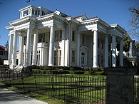
Gibson Hall is a building at Tulane University in New Orleans, Louisiana, United States. It sits across from Audubon Park.
The following is a timeline of the history of the city of New Orleans, Louisiana, USA.

The Carrollton Courthouse is a historic building in the Carrollton neighborhood of New Orleans, Louisiana, in the United States. Built in 1855, it originally served as a courthouse before being utilized by several public schools. In 2013, it became vacant after the previous tenant, a charter school, moved locations. In 2018, the Orleans Parish School Board sold the property to private developers. On February 15, 2023, the building was reopened as a luxury assisted living facility for senior citizens, after a three-year renovation to restore and repurpose the building.