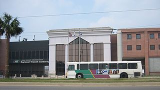
The New Orleans Regional Transit Authority is a public transportation agency based in New Orleans. The agency was established by the Louisiana State Legislature in 1979, and has operated bus and historic streetcar service throughout the city since 1983. In 2023, the system had a ridership of 9,707,300, or about 29,700 per weekday as of the second quarter of 2024, making the Regional Transit Authority the largest public transit agency in the state of Louisiana.

Streetcars in New Orleans have been an integral part of the city's public transportation network since the first half of the 19th century. The longest of New Orleans' streetcar lines, the St. Charles Avenue line, is the oldest continuously operating street railway system in the world. Today, the streetcars are operated by the New Orleans Regional Transit Authority (RTA).

Canal Street is a major thoroughfare in the city of New Orleans. Forming the upriver boundary of the city's oldest neighborhood, the French Quarter or Vieux Carré, it served historically as the dividing line between the colonial-era (18th-century) city and the newer American Sector, today's Central Business District.
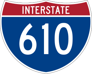
Interstate 610 (I-610) is a 4.52-mile-long (7.27 km) auxiliary route of I-10 that lies almost entirely within the city limits of New Orleans, Louisiana, bypassing its Central Business District.
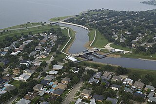
The Orleans Canal is a drainage canal in New Orleans, Louisiana. The canal, along with the 17th Street Canal and the London Avenue Canal, form the New Orleans Outfall Canals. The current version of the canal is about 2 km long, running along the up-river side of City Park, through the Lakeview and Lakeshore neighborhood, and into Lake Pontchartrain. It is part of the system used to pump rain water out of the streets of the city into the Lake. The Canal has also been known as the Orleans Avenue Canal, the Orleans Outfall Canal, the Orleans Tail Race, and early on, the Girod Canal.

The New Basin Canal, also known as the New Canal and the New Orleans Canal, was a shipping canal in New Orleans, Louisiana, operating from 1830s into the 1940s.
The 4th Ward or Fourth Ward is a division of the city of New Orleans, Louisiana, United States, one of the 17 Wards of New Orleans.

Navarre is a neighborhood of the city of New Orleans. A subdistrict of the Lakeview District Area, its boundaries as defined by the City Planning Commission are: I-610, Canal Boulevard and Florida Boulevard to the north, Orleans Avenue to the east, City Park Avenue to the south and the Pontchartrain Expressway and Pontchartrain Boulevard to the west.

Gentilly is a broad, predominantly middle-class and racially diverse section of New Orleans, Louisiana. The Gentilly neighborhood is bounded by Lake Pontchartrain to the north, France Road to the east, Bayou St. John to the west, and CSX Transportation railroad tracks to the south.

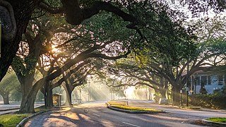
Lakeview is a neighborhood of the city of New Orleans. A subdistrict of the Lakeview District Area, its boundaries as defined by the City Planning Commission are: Allen Toussaint Boulevard to the north, Orleans Avenue to the east, Florida Boulevard, Canal Boulevard and I-610 to the south and Pontchartrain Boulevard to the west. Lakeview is sometimes used to describe the entire area bounded by Lake Pontchartrain to the north, the Orleans Avenue Canal to the east, City Park Avenue to the south and the 17th Street Canal to the west. This larger definition includes the West End, Lakewood and Navarre neighborhoods, as well as the Lakefront neighborhoods of Lakeshore and Lake Vista.

St. Charles Avenue is a thoroughfare in New Orleans, Louisiana, U.S. and the route of the St. Charles Streetcar Line. It is also famous for the dozens of mansions that adorn the tree-lined boulevard for much of the uptown section of the boulevard. It is named for St. Charles Borromeo, patron saint of Charles III of Spain, the monarch when France transferred the then-vast territory of Louisiana to Spain at the conclusion of the Seven Years' War in 1763.
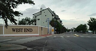
West End is a neighborhood of the city of New Orleans. A subdistrict of the Lakeview District Area, its boundaries as defined by the City Planning Commission are: Lake Pontchartrain to the north, the New Basin Canal and Pontchartrain Boulevard to the east, Veterans Boulevard to the south, and the 17th Street Canal to the west. The area was largely built on land reclaimed from Lake Pontchartrain. It is a commercial seafood and recreational boating hub for the city and has been known for its seafood restaurants. In recent years, the area has seen large condominium-complex developments built which overlook the Lake, marinas, and centrally located 30-acre (120,000 m2) West End Park.

Carrollton Avenue is a major thoroughfare stretching 3.9 miles (6.3 km) across the Uptown/Carrollton and Mid-City districts of New Orleans. South Carrollton Avenue runs from St. Charles Avenue in the Riverbend in a northeast lake-bound direction through Carrollton and into Mid-City. After crossing Canal Street it continues as North Carrollton Avenue until intersecting with Esplanade Avenue and Wisner Boulevard at the entrance to City Park.

The Canal Streetcar Line is a historic streetcar line in New Orleans, Louisiana. It is operated by the New Orleans Regional Transit Authority (RTA). It originally operated from 1861 to 1964. It was redesigned and rebuilt between 2000 and 2004, and operation was reinstated in 2004 after a 40-year hiatus. Primarily running along its namesake street, Canal Street, it consists of two branches named for their outer terminals, totaling about 5+1⁄2 miles (8.9 km) in length: "Canal–Cemeteries" and "Canal–City Park/Museum". As of 2024, each branch is denoted with light yellow and red colors respectively on most RTA publications.
City Park is a neighborhood of the city of New Orleans, US. A subdistrict of the Lakeview District Area, its boundaries as defined by the City Planning Commission are: Allen Toussaint Boulevard to the north, Bayou St. John to the east, Orleans Avenue, North Carrollton Avenue and Toulouse Street to the south and City Park and Orleans Avenues to the west. The neighborhood is named after and dominated by City Park.
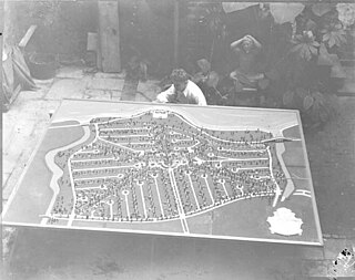
Lakeshore/Lake Vista is a neighborhood of the city of New Orleans, Louisiana. A subdistrict of the Lakeview District Area, its boundaries as defined by the City Planning Commission are: Lake Pontchartrain to the north, Bayou St. John to the east, Allen Toussaint Boulevard to the south and Pontchartrain Boulevard and the New Basin Canal to the west. The neighborhood is composed of the Lakeshore and Lake Vista subdivisions, built on land reclaimed from Lake Pontchartrain. The Lakefront is a term sometimes used to name the larger neighborhood created by the Orleans Levee Board's land reclamation initiative in early 20th century New Orleans; it includes Lakeshore and Lake Vista, as well as Lakeshore Drive and the lakefront park system, the University of New Orleans, Lake Terrace, and Lake Oaks.

Lakewood is a neighborhood of the city of New Orleans. A subdistrict of the Lakeview District Area, its boundaries as defined by the City Planning Commission are: Veterans Memorial Boulevard to the north, Pontchartrain Boulevard and the Pontchartrain Expressway to the east, Last, Quince, Hamilton, Peach, Mistletoe, Dixon, Cherry and Palmetto Streets to the south and the 17th Street Canal to the west.
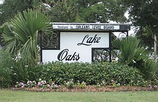
Lake Terrace/Lake Oaks is a neighborhood of the city of New Orleans, Louisiana. A sub-district of the city's Gentilly District, its boundaries as defined by the City Planning Commission are: Lake Pontchartrain to the north; the Industrial Canal to the east; Leon C. Simon Drive, Elysian Fields Avenue, New York Street, the London Avenue Canal, and Allen Toussaint Boulevard to the south; and Bayou St. John to the west. The neighborhood comprises the Lake Terrace and Lake Oaks subdivisions, the principal campus of the University of New Orleans, and the University of New Orleans Research & Technology Park — all built on land reclaimed from Lake Pontchartrain.

The Lafitte Greenway is a trail for pedestrians and bicycles located in New Orleans, Louisiana, extending from Louis Armstrong Park to Bayou St. John and beyond. Opened in 2015, it is the latest reconfiguration of a historic transportation corridor that has been in use for over two centuries.
Norman C. Francis Parkway, formerly named Jefferson Davis Parkway or Jeff Davis Parkway, is a street in New Orleans, Louisiana, United States. It runs southwest from the head of Bayou St. John in the Mid-City neighborhood to Martin Luther King, Jr. Boulevard in the Gert Town neighborhood. Like most streets in New Orleans, the segment of the parkway to the north east of Canal Street is named "North" Norman C. Francis Parkway while the segment to the southwest is denoted as "South". The parkway is wide with a grassy median except for where it crosses over the Pontchartrain Expressway.