Esplanade Avenue is a historic street in New Orleans, Louisiana. It runs northwest from the Mississippi River to Beauregard Circle at the entrance to City Park. [1]
Contents

Esplanade Avenue is a historic street in New Orleans, Louisiana. It runs northwest from the Mississippi River to Beauregard Circle at the entrance to City Park. [1]


Esplanade Avenue was an important 18th-century portage route of trade between Bayou St. John, which linked to Lake Pontchartrain, and the River. Many 19th-century mansions still line the street; it functioned as a "millionaires row" for the Creole section of the city similar to that of St. Charles Avenue for the Anglophone section in uptown New Orleans. [1]
Esplanade Avenue is the dividing line between the 6th and 7th Wards of the city.
From the River to Claiborne Avenue, Esplanade has one lane of traffic in both directions, with a raised neutral ground (median) in the center. From Claiborne to Carrollton Avenue it has one traffic lane in each direction, a dedicated bicycle lane, and a smaller neutral ground.
The segment from the River to Rampart Street separates the French Quarter from the Faubourg Marigny. Near the river on the French Quarter side is the old New Orleans Mint building. [1]
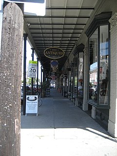
Passing by the Faubourg Treme neighborhood, Esplanade goes through the area known alternatively as Faubourg St. John or Esplanade Ridge, near the New Orleans Fairgrounds. The house where Edgar Degas stayed during his time in New Orleans is in this section. [2] [3]
Just past Carrollton Avenue is the entrance to the New Orleans Museum of Art. [1]
| Point | Coordinates (links to map & photo sources) | Notes |
|---|---|---|
| Mississippi River/Peters Street | 29°57′41″N90°03′28″W / 29.9614°N 90.0578°W | |
| Mid-point/Miro Street | 29°58′23″N90°04′26″W / 29.9730°N 90.0738°W | Approximate |
| Beauregard Circle | 29°59′02″N90°05′24″W / 29.9840°N 90.0899°W |

Streetcars in New Orleans have been an integral part of the city's public transportation network since the first half of the 19th century. The longest of New Orleans' streetcar lines, the St. Charles Avenue line, is the oldest continuously operating street railway system in the world. Today, the streetcars are operated by the New Orleans Regional Transit Authority (RTA).

Tremé is a neighborhood in New Orleans, Louisiana. "Tremé" is often rendered as Treme, and the neighborhood is sometimes called by its more formal French name, Faubourg Tremé; it is listed in the New Orleans City Planning Districts as Tremé / Lafitte, from when including the Lafitte Projects.

The Faubourg Marigny is a neighborhood of the city of New Orleans, Louisiana, United States.

The St. Charles Streetcar line is a historic streetcar line in New Orleans, Louisiana. It is the oldest continuously operating streetcar line in the world, as it has been in operation since 1835. It is operated by the New Orleans Regional Transit Authority (RTA). Officially the St. Charles Streetcar line is internally designated as Route 12, and it runs along its namesake street, St. Charles Avenue. It is the busiest route in the RTA system as it is heavily used by local commuters and tourists. On most RTA maps and publications, it is denoted in green, which is also the color of the streetcars on this line.

Uptown is a section of New Orleans, Louisiana, United States, on the east bank of the Mississippi River, encompassing a number of neighborhoods between the French Quarter and the Jefferson Parish line. It remains an area of mixed residential and small commercial properties, with a wealth of 19th-century architecture. It includes part or all of Uptown New Orleans Historic District, which is listed on the National Register of Historic Places.

The 8th Ward is a section of New Orleans, Louisiana. It is one of the Downtown Wards of New Orleans, with a Creole history.

The 7th Ward is a section of New Orleans, Louisiana. It is geographically the third largest of the 17 Wards of New Orleans, after the 9th Ward and 15th Ward.

The 17th Ward is one of the 17 Wards of New Orleans, a section of the city of New Orleans, Louisiana. New Orleans Districts and Wards. The 17th Ward, along with the 16th, was formed when the City of New Orleans annexed City of Carrollton in 1870.

The 6th Ward or Sixth Ward is one of the seventeen Wards of New Orleans, located in the Downtown section of the city of New Orleans, Louisiana.

The 14th Ward or Fourteenth Ward is a section of the city of New Orleans, Louisiana, one of the 17 Wards of New Orleans. The Ward was formed in 1870 from part of Jefferson City and the town of Greenville, which were annexed by New Orleans.
The 10th Ward is a division of the city of New Orleans, Louisiana. The 10th Ward is one of the 17 wards of New Orleans. The ward is one of the city's Uptown wards, formerly the old Faubourg Lafayette annexed by New Orleans in the 1850s.

Elysian Fields Avenue is a broad, straight avenue in New Orleans named after the Avenue des Champs-Élysées in Paris. It courses south to north from the Lower Mississippi River to Lake Pontchartrain, a distance of approximately 5 miles (8.0 km). The avenue intersects with Interstate 610, Interstate 10, and U.S. Highway 90, Gentilly Boulevard passing by Brother Martin High School. The part between North Claiborne Avenue and Gentilly Boulevard is Louisiana Highway 3021 ; the piece from N. Claiborne Avenue south to St. Claude Avenue carries Louisiana Highway 46.
U.S. Highway 90 Business is a business route of U.S. Highway 90 located in and near New Orleans, Louisiana. It runs 14.25 miles (22.93 km) in a general east–west direction from US 90 in Avondale to a junction with Interstate 10 (I-10) and US 90 in the New Orleans Central Business District.

U.S. Highway 90 (US 90), one of the major east–west U.S. Highways in the Southern United States, runs through southern Louisiana for 297.6 miles (478.9 km), serving Lake Charles, Lafayette, New Iberia, Morgan City, and New Orleans. Much of it west of Lafayette and east of New Orleans has been supplanted by Interstate 10 (I-10) for all but local traffic, but the section between Lafayette and New Orleans runs a good deal south of I-10.

St. Charles Avenue is a thoroughfare in New Orleans, Louisiana, U.S. and the home of the St. Charles Streetcar Line. It is also famous for the dozens of mansions that adorn the tree-lined boulevard for much of the uptown section of the boulevard.

Carrollton Avenue is a major thoroughfare stretching 3.9 miles (6.3 km) across the Uptown/Carrollton and Mid-City districts of New Orleans. South Carrollton Avenue runs from St. Charles Avenue in the Riverbend in a northeast lakebound direction through Carrollton and into Mid-City. After crossing Canal Street it continues as North Carrollton Avenue until intersecting with Esplanade Avenue and Wisner Boulevard at the entrance to City Park.

The Canal Streetcar line is a historic streetcar line in New Orleans, Louisiana. It is operated by the New Orleans Regional Transit Authority (RTA). It originally operated from 1861 to 1964. It was redesigned and rebuilt between 2000 and 2004, and operation was reinstated in 2004 after a 40-year hiatus. Primarily running along its namesake street, Canal Street, it consists of two branches named for their outer terminals, totaling about 5+1⁄2 miles (8.9 km) in length: "Canal - Cemeteries" and "Canal - City Park/Museum". Each branch is denoted with the red and light green colors respectively on most RTA publications.

Mid-City is a neighborhood of the city of New Orleans. A sub-district of the Mid-City District Area, its boundaries as defined by the New Orleans City Planning Commission are: City Park Avenue, Toulouse Street, North Carrollton, Orleans Avenue, Bayou St. John and St. Louis Street to the north, North Broad Street to the east, and the Pontchartrain Expressway to the west. It is a historic district on the National Register of Historic Places. In common usage, a somewhat larger area surrounding these borders is often also referred to as part of Mid-City.

Claiborne Avenue is a major thoroughfare in New Orleans, Louisiana. It runs the length of the city, about 9.5 miles (15.3 km), beginning at the Jefferson Parish line and ending at the St. Bernard Parish line; the street continues under different names in both directions. It is called South Claiborne Avenue upriver from Canal Street and North Claiborne Avenue from Canal to St. Bernard Parish.

Faubourg St. John, is a neighborhood in New Orleans, Louisiana, located just north of Broad Street at the intersection of Orleans Avenue. Faubourg St. John is approximately 75 city blocks in area and has an average elevation of about one foot above sea level. It was built along what is known as the Esplanade Ridge. The Esplanade Ridge Historic District was added to the National Register of Historic Places in 1980.
| Topics | |
|---|---|
| Government | |
| Colleges and Universities | |
| Sports |
|
| Festivals | |