Louisiana Highway 3152

Last updated

Louisiana 3152 (2008).svg

Louisiana Highway 3152
(South) Clearview Parkway
LA 3152 map.svg
Route information
Maintained by Louisiana DOTD
Length 3.8 mi [1] (6.1 km)
Existed 1972 – present
Major junctions
South endUS 90.svgLouisiana 48 (2008).svg US 90 / LA 48 in Elmwood
 US 61.svg US 61 in Metairie
North endI-10.svg I-10 in Metairie
Location
Parishes Jefferson
Highway system
  • Louisiana Highway System
Louisiana 3151 (2008).svg LA 3151 LA 3153 Louisiana 3153 (1955).svg

Louisiana Highway 3152 (LA 3152) is a state highway in Louisiana that serves Jefferson Parish. LA 3152 spans 3.8 miles (6.1 km) in a south to north direction [1] and is known locally as South Clearview Parkway and Clearview Parkway.

A state highway, state road, or state route is usually a road that is either numbered or maintained by a sub-national state or province. A road numbered by a state or province falls below numbered national highways in the hierarchy. Roads maintained by a state or province include both nationally numbered highways and un-numbered state highways. Depending on the state, "state highway" may be used for one meaning and "state road" or "state route" for the other.

Louisiana State of the United States of America

Louisiana is a state in the Deep South region of the South Central United States. It is the 31st most extensive and the 25th most populous of the 50 United States. Louisiana is bordered by the state of Texas to the west, Arkansas to the north, Mississippi to the east, and the Gulf of Mexico to the south. A large part of its eastern boundary is demarcated by the Mississippi River. Louisiana is the only U.S. state with political subdivisions termed parishes, which are equivalent to counties. The state's capital is Baton Rouge, and its largest city is New Orleans.

Jefferson Parish, Louisiana Parish in the United States

Jefferson Parish is a parish in the state of Louisiana. As of the 2010 census, the population was 432,552. The parish seat is Gretna.

Contents

Route description

LA 3152 begins at an interchange with U.S. 90 and LA 48 (Jefferson Highway) at the east bank base of the Huey P. Long Bridge in Elmwood. LA 3152 continues northward along South Clearview Parkway, intersecting with LA 3139 (Earhart Expressway) via an interchange. At U.S. 61 (Airline Drive), the local name changes to Clearview Parkway, and LA 3152 continues to an interchange with I-10. Clearview Parkway continues northward across Veterans Memorial Boulevard and eventually ends at Lake Pontchartrain.

U.S. Route 90 in Louisiana highway in Louisiana

U.S. Highway 90 in Louisiana , one of the major east–west U.S. Highways in the Southern United States, runs through southern Louisiana for 297.6 miles (478.9 km), serving Lake Charles, Lafayette, New Iberia, Morgan City, and New Orleans. Much of it west of Lafayette and east of New Orleans has been supplanted by Interstate 10 (I-10) for all but local traffic, but the section between Lafayette and New Orleans runs a good deal south of I-10.

Louisiana Highway 48 highway in Louisiana

Louisiana Highway 48 is a state highway in Louisiana that serves St. Charles and Jefferson Parishes. It runs from west to east, parallel to the east bank of the Mississippi River, from Norco to Jefferson. It spans a total of 20.9 miles (33.6 km). Throughout its run, LA 48 is known as Apple Street, River Road, 3rd Street, Reverend Richard Wilson Drive, and Jefferson Highway.

The Jefferson Highway was an automobile highway stretching through the central United States from New Orleans, Louisiana, to Winnipeg, Manitoba, Canada. The Jefferson Highway was replaced with the new numbered US Highway system in the late 1920s. Portions of the highway are still named Jefferson Highway, for example: the portions that run through Jefferson Parish, Louisiana; East Baton Rouge Parish, Louisiana; Lee's Summit, Missouri; Osseo, Minnesota; and Wadena, Minnesota.

LA 3152 is a divided, six-lane highway for its entire length.

History

Clearview Parkway began as a main thoroughfare through the Bridgedale subdivision which opened in 1925 during construction of the Airline Highway between Shrewsbury (Metairie) and Kenner. In 1930, it was designated as State Route 1245 in the pre-1955 Louisiana Highway system. The other main thoroughfare, Transcontinental Drive (State Route 1246), was intended to be extended south to Jefferson Highway (State Route 1) to connect with the Huey P. Long Bridge then in the planning stages. These plans never came to fruition, and the Bridgedale area would not be not directly connected to the bridge for almost fifty years.

Shrewsbury, Louisiana

Shrewsbury was an unincorporated town in Jefferson Parish, Louisiana, along the Mississippi River and Shrewsbury Road about 1 mile upriver from the border of the city of New Orleans. The name came into use in the mid-19th century, and became less commonly used towards the end of the 20th century, when surrounding communities of unincorporated Jefferson grew together as a suburb of New Orleans. The area is now generally known as Old Jefferson and is part of the Greater New Orleans Metropolitan area.

Kenner, Louisiana City in Louisiana, United States

Kenner is the seventh-largest city in the U.S. State of Louisiana following New Orleans, Baton Rouge, Shreveport, Lafayette, Lake Charles and Bossier City. It is the largest city in Jefferson Parish and the largest incorporated suburban city of New Orleans. The population was 66,702 at the 2010 census.

The route became LA 611-10 in the 1955 Louisiana Highway renumbering and assumed its present number in 1972. The extension of Clearview Parkway, complete with railroad overpass, south from Airline Highway to the Huey P. Long Bridge at Jefferson Highway, opened in June 1973 and was designated as South Clearview Parkway. The Earhart Expressway (LA 3139) interchange was partially completed in the 1970s as part of the Clearview Parkway-Dickory Avenue section of the expressway. The overpass was completed in June 1986 along with the final link of the expressway between Cleary Avenue and Clearview Parkway.

In 1955, Louisiana passed a law that undertook a comprehensive revision to the state highway classification and numbering system. The new system designated roads by importance to travel patterns and rectified the previous numbering system under new unified designations.

LA 3152 originally included only the part of Clearview Parkway/South Clearview Parkway between the Earhart Expressway and West Metairie Avenue. In 2010, the route was extended on both the northern and southern ends to its present termini at U.S. 90/LA 48 and I-10.

Major intersections

The entire highway is in Jefferson Parish.

Locationmi [1] kmDestinationsNotes
Elmwood 0.00.0US 90.svg US 90 (Jefferson Highway, Huey P. Long Bridge) New Orleans, Westbank
Louisiana 48 (2008).svg LA 48 west (Jefferson Highway)
Interchange; Huey P. Long Bridge across Mississippi River on the southeast
1.21.9Louisiana 3139 (2008).svg LA 3139 (Earhart Expressway) Harahan, New Orleans Interchange
Metairie 1.82.9US 61.svg US 61 (Airline Drive) Kenner, New Orleans
3.86.1I-10.svg I-10  Baton Rouge, New Orleans Exit 226 (I-10)
1.000 mi = 1.609 km; 1.000 km = 0.621 mi

Related Research Articles

Interstate 310 (Louisiana)

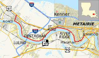
Interstate 310 (I-310) is a short spur route of I-10 west of New Orleans, located entirely in St. Charles Parish, Louisiana, United States.

Interstate 110 (I-110) is an auxiliary Interstate Highway in the U.S. state of Louisiana. It runs 9.06 miles (14.58 km) in a north–south direction as a spur of I-10 in the city of Baton Rouge.

Interstate 610 (I-610) is a 4.92-mile-long (7.92 km) auxiliary route of Interstate 10 that lies almost entirely within the city limits of New Orleans, Louisiana, bypassing its Central Business District.

U.S. Route 90 Business (New Orleans, Louisiana) highway in New Orleans, Louisiana

U.S. Highway 90 Business is a business route of U.S. Highway 90 located in and near New Orleans, Louisiana. It runs 14.33 miles (23.06 km) in a general east–west direction from a point on US 90 between Avondale and Westwego to the junction of Interstate 10 (I-10) and US 90 in the New Orleans Central Business District.

Airline Highway highway in Louisiana

Airline Highway is a divided highway in the U.S. state of Louisiana, built in stages between 1925 and 1953 to bypass the older Jefferson Highway. It runs 115.6 miles (186.0 km), carrying U.S. Highway 61 from New Orleans northwest to Baton Rouge and U.S. Highway 190 from Baton Rouge west over the Mississippi River on the Huey P. Long Bridge. US 190 continues west towards Opelousas on an extension built at roughly the same time.

Louisiana Highway 1 highway in Louisiana

Louisiana Highway 1 (LA 1) is a state highway in Louisiana. At 431.88 miles (695.04 km), it is the longest numbered highway of any class in Louisiana. It runs diagonally across the state, connecting the oil and gas fields near the island of Grand Isle with the northwest corner of the state, north of Shreveport.

Louisiana Highway 23 highway in Louisiana

Louisiana Highway 23 is a north–south state highway in Louisiana that serves Plaquemines and Jefferson Parishes. It spans 74.0 miles (119.1 km) in roughly a southeast to northwest direction. It is known locally as Belle Chasse Highway, Lafayette Street, the West Bank Expressway, and Franklin Avenue.

Earhart Expressway highway in Louisiana

The Earhart Expressway, named for former New Orleans Commissioner of Public Utilities, Fred A. Earhart, is a state highway located in both Jefferson Parish and Orleans Parish, Louisiana. It is also designated as Louisiana Highway 3139, spanning a total of 5.2 miles (8.4 km). Although it is an odd-numbered highway and is bannered north/south, it travels in a more east-to-west direction.

Louisiana Highway 18 highway in Louisiana

Louisiana Highway 18 is a state highway that serves Ascension, St. James, St. John the Baptist, St. Charles, and Jefferson Parishes. Called the Great River Road, it runs from west to east, parallel to the west bank of the Mississippi River, running from Donaldsonville to Gretna. It spans a total of 79.7 miles (128.3 km). In the more rural parts of LA 18's span, it is commonly referred to as River Road, but it becomes 4th Street once it enters Westwego.

Louisiana Highway 611 highway in Louisiana

Louisiana Highway 611 is a collection of three current and ten former state-maintained streets in Jefferson, Metairie, and New Orleans. All thirteen routes were established with the 1955 Louisiana Highway renumbering.

Louisiana Highway 560 is a collection of two current and two former state-maintained streets in Marrero and Crown Point, Jefferson Parish. All four routes were established with the 1955 Louisiana Highway renumbering.

Louisiana Highway 49 highway in Louisiana

Louisiana Highway 49 (LA 49) is a state highway located in Jefferson Parish, Louisiana. It runs 3.93 miles (6.32 km) in a north–south direction along Williams Boulevard from U.S. Highway 61 (US 61) to an intersection with Joe Yenni Boulevard and 44th Street in Kenner.

Louisiana Highway 3046 is a state highway in Louisiana that serves Jefferson Parish. It spans 1.0 mile (1.6 km) in a south to north direction. It is known locally as Causeway Boulevard.

Louisiana Highway 3134 is a state highway in Louisiana that serves Jefferson Parish. It spans 7.2 miles (11.6 km) in a north-south direction along Leo Kerner/Lafitte Parkway between Jean Lafitte and Estelle and acts as a four-lane bypass to the older Barataria Boulevard.

Louisiana Highway 613 was a collection of four state-maintained streets in Metairie and New Orleans established with the 1955 Louisiana Highway renumbering. All four routes have since been deleted from the state highway system.

References

  1. 1 2 3 Microsoft; Nokia (November 14, 2012). "Map of LA 3152" (Map). Bing Maps . Microsoft. Retrieved November 14, 2012.

Route map: Google

KML file (edithelp)
KML is from Wikidata