Aughris (Irish: Eachrois, meaning 'point of the horses') is a coastal townland in County Sligo, in the west of Ireland. It is also the name given to a prominent headland that includes the townlands of Aughris, Garryduff, Kilrusheighter and Rathglass. The area has been settled since at least medieval times and there are several archaeological remains in the vicinity.
Aughris now has a small harbour used by inshore fishermen and a public house known as Beach Bar. The geology of the area is limestone, with examples of fossilized coral fauna visible in exposed coastal areas.
A tiny clachán-type village located close to the coast is now largely abandoned. Most existing houses cluster near the harbour and public house.[citation needed]
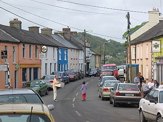
Union Hall, also Unionhall, is a small fishing village located in County Cork, Ireland, located on the west side of Glandore Harbour. Its nearest neighbour to the west is Castletownshend; to the east, Glandore village. It is approximately 10 kilometres south-east of Skibbereen. As of the 2016 census, 270 people were living in Union Hall.
Dunboy Castle is a ruined 15th-century castle on the Beara Peninsula in south-west Ireland near the town of Castletownbere. The castle's tower house and bawn were destroyed in the 1602 Siege of Dunboy, though its ruins remain open to the public.
The village of Rosslare Harbour, also known as Ballygerry, grew up to serve the needs of the harbour of the same name, first developed in 1906 by the Great Western Railway and the Great Southern and Western Railway to accommodate steamferry traffic between Great Britain and Ireland. This port also serves France and Spain, traffic is mainly roll-on roll-off (RoRo). Rosslare Harbour railway station opened on 30 August 1906.
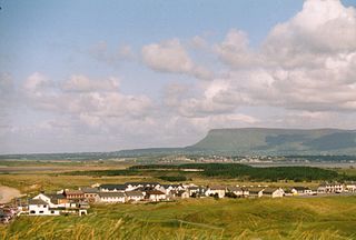
Strandhill or occasionally Larass is a coastal town and townland on the Coolera Peninsula in County Sligo, Ireland. As of 2016, the population was 1,753, an increase of 10% from the 2011 census. The old name appears to be Ros Dragnige.
Killeenduff is a townland within the boundaries of the civil parish of Easky, County Sligo in Ireland. Located about a mile from the village of Easky, Killeenduff has an area of approximately 4 square kilometres (1.5 sq mi).
Kilskeery is a small village and civil parish in County Tyrone, Northern Ireland. It is between Ballinamallard and Trillick. In the 2001 census it had a population of 57 people. Kilskeery is within the Omagh District Council area.
Ballynary is a townland on the eastern shore of Lough Arrow in south County Sligo, Ireland. Ballynary was the ancestral seat of the O'Higgins family for 700 years, until they were forced off their lands in 1654 by Oliver Cromwell.
Shanmaghery or Shanmaghry is a small hamlet and townland in County Tyrone, Northern Ireland, situated three miles from Pomeroy and three miles from Galbally. It is situated in the barony of Dungannon Middle and the civil parish of Pomeroy and covers an area of 426 acres. In 1841 the population of the townland was 193 people and in 1851 it was 161 people. "Paul's Planting" was a notable landmark on top of the hill.
Altmore ) is a hamlet and townland in County Tyrone, Northern Ireland. It is five miles from Carrickmore and four miles from Pomeroy. The townland is actually called Altmore and is situated in the historic barony of Dungannon Middle and the civil parish of Pomeroy and covers an area of 1117 acres.
Tullavilla is a townland near Tubbercurry in County Sligo, Ireland. It is a quiet rural area, at the foot of the Ox Mountains with a mainly farming community.
Evish is a small rural community area and townland in County Tyrone, Northern Ireland, 3 miles from Strabane and 7 miles from Plumbridge. It is situated in the barony of Strabane Lower and the civil parish of Camus and covers an area of 870 acres.
Carrowkeel is a cluster of passage tombs in south County Sligo, Ireland. They were built in the 4th millennium BC, during the Neolithic era. The monuments are on the Bricklieve Hills, overlooking Lough Arrow, and are sometimes called the Bricklieve tombs. They are named after the townland of Carrowkeel in which most of them are located. Nearby are the Caves of Kesh and Heapstown Cairn. The Carrowkeel tombs are protected National Monuments and are considered one of the "big four" passage tomb cemeteries in Ireland, along with Carrowmore, Brú na Bóinne and Loughcrew.
Sooey, is a village in County Sligo in Ireland. The village is situated near Riverstown, on the R284 road which runs between Sligo and Leitrim village in County Leitrim.
Temple House is a Georgian mansion set in an estate of over 1,000 acres (400 ha). It overlooks the lakeside ruins of a castle formerly of the Knights Templar, and is now a country guest house. Originally built c. 1825, it was substantially extended and embellished c. 1864.
Sligo Bay is a natural ocean bay in County Sligo, Republic of Ireland.
The Maugherow Peninsula is the largest and westernmost peninsula of County Sligo, Ireland. It is also less commonly referred to as the Raghly Peninsula, after Raghly Point, which is itself a headland of the peninsula. The peninsula acts as the northern boundary of Sligo Bay.
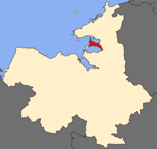
The Rosses Point Peninsula is a small peninsula in the centre of Sligo Bay, County Sligo, Ireland. The peninsula shares its name with the village of Rosses Point, a popular seaside resort located on the peninsula's southern coast, roughly 7.5 km (5 mi) west of Sligo town.
The Coolera Peninsula is a peninsula in Sligo Bay, County Sligo, Ireland. It is the most populous of County Sligo's peninsulas, and the second-largest by land area. The primary population centres on Coolera are the coastal town of Strandhill on its western shore, and Magheraboy, a suburb of Sligo town.
Ballincar is a small village and townland in County Sligo, Ireland. The townland is in the civil parish of Drumcliff, and has an area of approximately 1.6 square kilometres (0.62 sq mi). It is a largely linear coastal settlement which overlooks Sligo Bay and lies on the R291 regional road between Sligo town and Rosses Point. As of the 2016 census, the census town of Ballincar had a population of 424 people.
Inch is a small coastal settlement and townland on the Dingle Peninsula in County Kerry, Ireland. Inch Strand, in Inch townland, is on a long sand spit and dune system which reaches into Dingle Bay. The R561 regional road passes through the area.
This page is based on this Wikipedia article Text is available under the CC BY-SA 4.0 license; additional terms may apply. Images, videos and audio are available under their respective licenses.