
Carrick-on-Shannon is the county town of County Leitrim in Ireland. It is the largest town in the county of Leitrim. A smaller part of the town lies in County Roscommon. The population of the town was 4,062 in 2016. It is situated on a strategic crossing point of the River Shannon. The Leitrim part of the town is in the civil parish of Kiltoghert which is in the ancient barony of Leitrim.
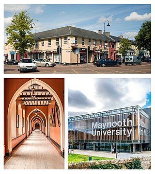
Maynooth is a university town in north County Kildare, Ireland. It is home to Maynooth University and St Patrick's College, a Pontifical University and Ireland's sole Roman Catholic seminary. Maynooth is also the seat of the Irish Catholic Bishops' Conference and holds the headquarters of Ireland's largest development charity, Trócaire. Maynooth is located 24 kilometres west of central Dublin.
Blanchardstown is a large outer suburb of Dublin in the modern county of Fingal, Ireland. Located ten kilometres (6 mi) northwest of Dublin city centre, it has developed since the 1960s from a small village to a point where Greater Blanchardstown is the largest urban area in Fingal.

Enniscrone – also spelt Inniscrone and officially named Inishcrone – is a small seaside town in County Sligo, Ireland. Its sandy beach, tourist campsite, and golf course all attract visitors. As of the 2016 census, the town had a population of 1,156 people.

Killala is a village in County Mayo in Ireland, north of Ballina. The railway line from Dublin to Ballina once extended to Killala. To the west of Killala is the townland of Townsplots West, which contains a number of ancient forts. Historically associated with Saint Patrick, and the seat of an episcopal see for several centuries, evidence of Killala's ecclesiastical past include a 12th century round tower and the 17th century Cathedral Church of St Patrick. As of the 2016 census of Ireland, the village had a population of 562.

Roosky, Ruskey, or Rooskey is a village on the River Shannon in the northern midlands of Ireland, near the point where counties Leitrim, Longford, and Roscommon meet. The N4 road from Dublin to Sligo passes by the Leitrim side of the village.

Kiltale is a small rural community district in County Meath, Ireland with a population of approx. 300. Kiltale is situated on the R154 regional road, the main Dublin to Trim road. It is approximately 9 km east of Trim, about 9 km west of Dunshaughlin and 19 km south of Navan. Kiltale is just over 7 km from the historical seat of the High King of Ireland at the Hill of Tara.

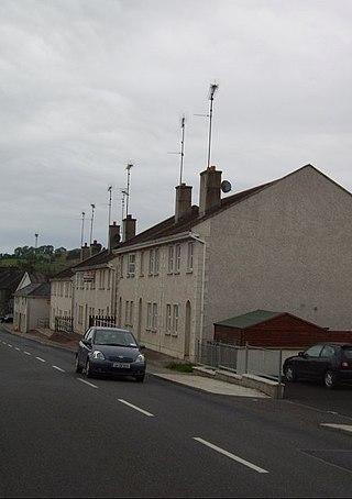
Stranorlar is a town, townland and civil parish in the Finn Valley of County Donegal, in Ireland. Stranorlar and Ballybofey form the Twin Towns.
Newtown Cunningham, usually spelled Newtowncunningham or abbreviated to Newton, is a village and townland in the Laggan district in the east of County Donegal, Ireland, located on the N13 road 18 kilometres (11 mi) east of Letterkenny and 16 km (10 mi) west of Derry. At the 2016 census, the village population was 1,080.

Belleek is a large village and civil parish in County Fermanagh, Northern Ireland. While the greater part of the village lies within County Fermanagh, part of it crosses the border and the River Erne into County Donegal. It lies in the historic barony of Lurg. It had a population of 904 people in the 2011 Census, and is situated within Fermanagh and Omagh district.
Laghy or Laghey is a village and townland in County Donegal, Ireland, between Ballintra and Donegal Town. It is one of three villages that make up the parish of Drumholm, formerly a civil and Church of Ireland parish, now only used as a division of the Roman Catholic Diocese of Raphoe. The village has a quarry, a supermarket, garden centre, filling station, two public houses, a church with a graveyard, an Orange hall, a recycling centre, a Donegal County Council yard and salt depot, and a national school. Rossnowlagh and Murvagh beaches are nearby. Murvagh is also the home to Donegal Golf Club.

Kilmacow is a small village and townland in County Kilkenny, Ireland.

Ballinspittle is a village in County Cork, Ireland. It is in the barony of Courceys and lies about 8 km (5 mi) southwest of Kinsale, on the R600 road. It is near Garrylucas and Garrettstown Blue Flag beaches.

The villages of Killucan and Rathwire are co-located in the east of County Westmeath, Ireland. They have a combined population of 1,370 according to the 2016 census. Killucan is on the R156 road about 15 km (9.3 mi) from Mullingar and 60 km (37 mi) from Dublin.

Tullyallen is a village, civil parish and townland 6 km north-west of the town of Drogheda in County Louth, Ireland. It is in the historic Barony of Ferrard. It is located in the historical Boyne Valley, in the Catholic parish of Mellifont ; it is also close to Newgrange, Knowth and Dowth burial mounds, Monasterboice monastery, and to the Battle of the Boyne site.

Clogherhead is a fishing village in County Louth, Ireland. Located in a natural bay on the east coast it is bordered by the villages of Annagassan to the north and Termonfeckin to the south. It has a population of 2,145 according to the 2016 census. It is located in the townlands of Clogher and Callystown, about 12 km (7 mi) northeast of Drogheda. As a seaside village, its main industries are fishing and farming, and there has been an RNLI lifeboat stationed in the village for over 100 years.

Kilcummin is a beachhead and civil parish on the northern coast of County Mayo in Ireland. Traditionally a fishing community, the Kilcummin area is sparsely populated. The "Tír Sáile - North Mayo Sculpture Trail" and "Tour d'Humbert" tourist route lead through the area. Kilcummin overlooks Killala Bay, the blue flag beach "An Trá nRoss", "Bartra Island" and lies on the opposite shore to Enniscrone and its beach in County Sligo.

Ballinderreen is a village located on the N67 route between Kilcolgan and Kinvara in south County Galway, in Ireland.

Ballynacargy, or Ballinacarrigy, is a small village in County Westmeath, Ireland on the Royal Canal and the R393 regional road. The last official commercial navigation of the canal took place in 1955.
Kilnaleck or Kilnalec is a small village in County Cavan, Ireland on the R154 regional road. Kilnaleck was once the centre of a mining boom when in 1879 some local businessmen and a school headmaster decided to develop the coal that existed nearby. However, the coal was very deep and hard to extract and the mine was forced to close. The village is part of Crosserlough parish.

