Geevagh

Last updated

Geevagh
An Ghaobhach
Village
Ireland adm location map.svg
Red pog.svg
Geevagh
Location in Ireland
Coordinates: 54°05′57″N8°15′02″W / 54.0993°N 8.2505°W / 54.0993; -8.2505
Country Ireland
Province Connacht
County County Sligo
Elevation
90 m (300 ft)
Time zone UTC+0 (WET)
  Summer (DST) UTC-1 (IST (WEST))
Irish Grid Reference G835168
St Brigid's RC Church, Highwood, Geevagh St Brigid's Church, Highwood, Geevagh.JPG
St Brigid's RC Church, Highwood, Geevagh

Geevagh (Irish : An Ghaobhach, meaning "windy place") [1] [2] is a village in the south-east corner of County Sligo, Ireland, on the R284 regional road. The name, meaning "the windy (place)", describes a climatic feature of the village and its surrounding countryside. The name Geevagh also refers to the local Catholic parish, the boundaries of which are wider than those of the village itself.

Contents

Geography

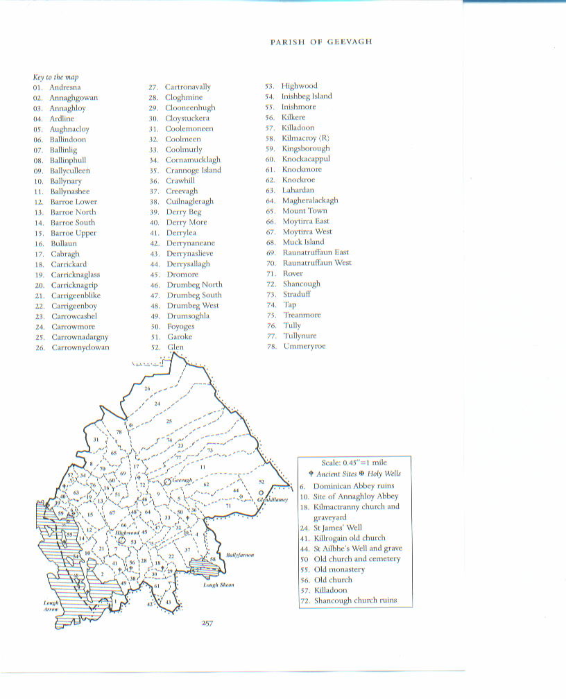
Geevagh and most of its surrounding parish lie wedged between Carrane Hill (458 m) to the north east and a series of drumlins to the south west, roughly 170 m in height. Two notable lakes lie encircled by these hills to the south west: Lough Bo (93 m) and Lough Nasool (109 m). Lough Nasool (Lake of the Eye) is unusual in that it has on several occasions drained away, and in the summer of 2006 it almost completely drained, diverted into underground channels.

Lying just beyond the southern borders of Geevagh lies a much larger lake: Lough Arrow. To the east lies the border with County Roscommon and to the north beyond Carrane Hill lies County Leitrim. To the west lies the village of Riverstown and most of County Sligo. The underlying rock structure is a combination of limestone, shale and sandstone, many examples of which can be seen in the local stone walls. A blanket bog covers the top of Carrane Hill and boggy land with poor quality soil is a feature of the local farms, the shallow soil being fertile enough to support only low density mixed farming of cattle and sheep. As a consequence of this, many local farmers supplement their meager income from farming with wages from jobs in the local big town of Sligo. One of the few local industries that supplied work to generations of men from the locality was the Arigna coal mines, located near the community of Glenkillamey to the north of Geevagh. This mine was in operation in one form or another since the 18th century and provided a low grade coal to a small power station operated by the ESB (Electricity Supply Board) since 1958. However the mine closed for the last time in 1990 hitting the local communities hard, particularly in the Arigna/Glenkillamey area. In keeping with its past involvement in power generation, 2005 saw the installation of six wind turbines at Carrownadargny. These electricity generating turbines are each capable of producing 0.85MW of power, and are manufactured by the Spanish company Gamesa.[ citation needed ] The towers on which the turbines stand are 44 metres high, with a combined blade diameter of 52 metres. The turbines can produce enough energy to save 13770 tonnes of CO2.[ citation needed ]

History

The headstone of Terence McDonough in Ballindoon Abbey Mc Donough.JPG
The headstone of Terence McDonough in Ballindoon Abbey

In common with much of County Sligo, there are many signs of ancient habitation in the locality, including cairns, megalithic tombs, and ring forts. Later signs of early Christian structures includes the ruins of a church attributed to Saint Patrick. Many of these old structures have spawned a rich story-telling tradition in the locality with many outlandish tales explaining their origins, such as the tale "Balor of the Evil Eye" being associated with the disappearance of Lough Nasool.

There is however evidence of many church ruins including in particular Ballindoon Abbey on the shores of Lough Arrow, a Dominican Priory from the early 16th century. It contains the grave of Terence McDonough, a member of the local clan that governed much of the area prior to the post-Cromwellian seizure of the land in the parish and its dispersal amongst English settler families such as King and Nicholson, and later its transfer to landlords such as Duke, Keogh and Whitney. Despite undoubted hardship, including sustained emigration, the community survived through resilience, finding sustenance in the family, the Roman Catholic church, the Gaelic Athletic Association, music and the local pubs, though not necessarily in that order.

Geevagh: Carrane Hill with Lough Bo in the left foreground Carran Hill.jpg
Geevagh: Carrane Hill with Lough Bo in the left foreground
Lough Arrow with some of its many islands Lough Arrow.JPG
Lough Arrow with some of its many islands
Lough Nasool, making a reappearance Nov 2006 Lough Nasool.JPG
Lough Nasool, making a reappearance Nov 2006

2008 marked a centenary in the history of Geevagh. As of 1908, widespread evictions from the local Keogh estate meant many poor families eked out an existence of sorts on the rough barren slopes of Carrane Hill. A campaign of non-payment of rent exposed many families to such a fate, and in an effort to prevent further evictions, the Land League organised demonstrations to prevent delivery of eviction notices by local postmen, which led to several confrontations in January 1908 between a large number of citizens and the police. Court cases ensued against around two dozen locals, some of whom ended up serving hard labour in prison for up to six months. While the court cases and prison terms were ongoing, the local community rallied around the families of the prisoners, making sure their farms were worked and tilled. It was not until summer 1909 that a resolution came with the release of the last prisoners, to much local rejoicing by the parish as a whole. John C. Mc Ternan in his book Olde Sligo (1997) records the 1908 events in detail.[ citation needed ]

A new school was built in 2001, followed by several new building projects around Geevagh crossroads.[ citation needed ] However, in keeping with many other communities post the 2008 financial crisis, emigration became the only option for young people in a stagnant economy.[ citation needed ]

Notable people

See also

Further reading

Related Research Articles

<span class="mw-page-title-main">County Leitrim</span> County in Ireland

County Leitrim is a county in Ireland. It is in the province of Connacht and is part of the Northern and Western Region. It is named after the village of Leitrim. Leitrim County Council is the local authority for the county, which had a population of 35,199 according to the 2022 census.

<span class="mw-page-title-main">County Roscommon</span> County in Ireland

County Roscommon is a county in Ireland. It is part of the province of Connacht and the Northern and Western Region. It is the 11th largest Irish county by area and 27th most populous. Its county town and largest town is Roscommon. Roscommon County Council is the local authority for the county. The population of the county was 69,995 as of the 2022 census.

<span class="mw-page-title-main">Drumshanbo</span> Town in County Leitrim, Ireland

Drumshanbo is a small town situated in the heart of County Leitrim, Ireland. Drumshanbo is surrounded by a scenic area of soft rolling hills, woodlands, lakes and the Sliabh an Iarainn and Arigna mountains. It is a well preserved town with traditional pubs, shops, and restaurants.

<span class="mw-page-title-main">Lahardane</span> Village in County Mayo, Ireland

Lahardane, also sometimes spelled Lahardaun, is a village in the parish of Addergoole, County Mayo, Ireland, adjacent to Lough Conn and to Nephin, and close to the towns of Crossmolina, Castlebar and Ballina. The 2016 census recorded a population of 178.

<span class="mw-page-title-main">Belleek, County Fermanagh</span> Village and civil parish in County Fermanagh, Northern Ireland

Belleek is a large village and civil parish in County Fermanagh, Northern Ireland. While the greater part of the village lies within County Fermanagh, part of it crosses the border and the River Erne into County Donegal. It lies in the historic barony of Lurg. It had a population of 904 people in the 2011 Census, and is situated within Fermanagh and Omagh district, around 7 kilometres (4 mi) east of Ballyshannon.

<span class="mw-page-title-main">Ballyfarnon</span> Village in County Roscommon, Ireland

Ballyfarnon is a village in northern County Roscommon, Ireland. Built on the River Feorish at the foot of Arigna Mountain, it lies between Loughs Skean and Meelagh with Lough Arrow, Lough Allen, Lough Bo and Lough-na-Sool nearby. It lies on the Sligo/Leitrim R284 regional road on the border with County Sligo.

<span class="mw-page-title-main">Arigna</span> Village in County Roscommon, Ireland

Arigna, is a village in County Roscommon, Ireland. It is near Lough Allen, on a designated scenic route between Keadue and Sliabh an Iarainn. Arigna is situated in Kilronan Parish alongside the villages of Keadue and Ballyfarnon. The village lies close to the shores of Lough Allen. There is a long association with the coal mining industry, carried out for over 400 years until the mines closed in 1990.

Monasteraden is a village in County Sligo, Ireland. The village is located on the shores of Lough Gara. St Aiden's church is the village's church. Other sites include Lough Gara Lodge, Slí na Croí's Roundhouse Ecolodge, Drury's pub and the general store.

<span class="mw-page-title-main">Dromahair</span> Village in County Leitrim, Ireland

Dromahair is a village in County Leitrim, Ireland. Dromahair is 10 km (6 mi) from Manorhamilton and 17 km (10 mi) from Sligo town.

<span class="mw-page-title-main">Kinlough</span> Village in County Leitrim, Ireland

Kinlough is a large village in north County Leitrim. It lies between the Dartry Mountains and the Atlantic Ocean, and between the River Duff and the River Drowes, at the head of Lough Melvin. It borders County Donegal and County Fermanagh, both in Ulster, and is near Yeats Country in County Sligo. It lies 2.5 miles from Bundoran in County Donegal, and across Lough Melvin from the village of Garrison in County Fermanagh.

<span class="mw-page-title-main">Pettigo</span> Village in County Donegal, Ireland and County Fermanagh, Northern Ireland

Pettigo, also spelt Pettigoe, is a small village and townland on the border of County Donegal, Republic of Ireland, and County Fermanagh, Northern Ireland. It is bisected by the Termon River which is part of the border between the Republic of Ireland and Northern Ireland.

<span class="mw-page-title-main">Ramelton</span> Small town in County Donegal, Ireland

Ramelton, also Rathmelton, is a town and townland in County Donegal, Ireland. As of 2016, its population was 1,266.

<span class="mw-page-title-main">Blacklion</span> Village in County Cavan, Ireland

Blacklion is a border village in west County Cavan, Ireland. It is situated on the N16 national primary road, just across the border from the County Fermanagh village of Belcoo.

Carmel Gunning is an Irish composer and musician, from Sligo, Ireland. Gunning is one of Ireland's most accomplished tin whistle players who is also known for her singing and flute playing and also plays guitar and button accordion. Gunning's rich stylised form of whistle playing and tradition stems from her homeland of Geevagh in South County Sligo. This background and tradition aided Gunning's introduction to traditional Irish music which took place at an early age.

<span class="mw-page-title-main">Rathmullan</span> Seaside village in County Donegal, Ireland

Rathmullan is a seaside village and townland on the Fanad Peninsula in County Donegal, Ireland. It is situated on the western shore of Lough Swilly, 11 kilometres (7 mi) north-east of Ramelton and 12 km (7 mi) east of Milford. Rathmullan was the point of departure during the Flight of the Earls in 1607, a major turning point in Irish history.

<span class="mw-page-title-main">Ardboe</span> Parish in County Tyrone, Northern Ireland

Ardboe is a large parish civil parish in east County Tyrone, Northern Ireland. It borders the western shore of Lough Neagh and lies within the Mid Ulster District Council area. It is also the name of the local civil parish, which incorporates both Mullinahoe and Moortown.

<span class="mw-page-title-main">Knockvicar</span> Village in Connacht, Ireland

Knockvicar is a village in County Roscommon, Ireland. It is located on the R285 regional road, between Boyle and Carrick-on-Shannon near Lough Key Forest Park in the north of the county.

<span class="mw-page-title-main">Drumconrath</span> Village in County Meath, Ireland

Drumconrath or Drumcondra is a small village in north County Meath, Ireland. The parish borders County Louth and is also close to the borders of Counties Monaghan and Cavan. As of the 2016 census, the village had a population of 345 people.

<span class="mw-page-title-main">Miners Way and Historical Trail</span>

The Miners' Way and Historical Trail is a long-distance trail in Ireland. It is a 118-kilometre (73-mile) long circular route that begins and ends in Arigna, County Roscommon. It is typically completed in five days. It is designated as a National Waymarked Trail by the National Trails Office of the Irish Sports Council and is managed by Roscommon Integrated Development Company, Roscommon County Council, Leitrim County Council and Sligo County Council. The trail was developed to encourage tourism in the area in the wake of the closure of the Arigna mines in 1990. The route was originally conceived by a local priest, Father Sean Tynan, and built with funding from the European Regional Development Fund. The trail was opened by broadcaster Donncha Ó Dúlaing in July 2000.

<span class="mw-page-title-main">Gubbarudda</span> Townland in Connacht, Ireland

Gubbarudda, formerly Gubberudda is a townland in County Roscommon, Ireland about 4.5 kilometres north-west from the village of Arigna. Gubbarudda is a very rural area composed of 432 acres with only two residences. Much of the northern parts of the townland encompasses Coillte woodlands, while its southern areas are situated on the 'Kilronan Mountain Bog Natural Heritage Area'. The population of Gubbarudda as of 2012 totaled eight people.

References

  1. "An Ghaobhach / Geevagh". logainm.ie. Irish Placenames Commission. Retrieved 14 March 2020.
  2. "Geevagh Community - About". geevagh.ie. Retrieved 14 March 2020.