Aurora Subglacial Basin

Last updated

Aurora Subglacial Basin is a large subglacial basin of Wilkes Land to the west of Dome Charlie and trending northwest toward the coast in the vicinity of Shackleton Ice Shelf. The basin was delineated by the SPRI-NSF-TUD airborne radio echo sounding program, 196779, and named after Aurora, the ship of the Australasian Antarctic Expedition, 191114, led by Douglas Mawson.

Structural basin geological depression

A structural basin is a large-scale structural formation of rock strata formed by tectonic warping of previously flat-lying strata. Structural basins are geological depressions, and are the inverse of domes. Some elongated structural basins are also known as synclines. Structural basins may also be sedimentary basins, which are aggregations of sediment that filled up a depression or accumulated in an area; however, many structural basins were formed by tectonic events long after the sedimentary layers were deposited.

Wilkes Land geographic region

Wilkes Land is a large district of land in eastern Antarctica, formally claimed by Australia as part of the Australian Antarctic Territory, though the validity of this claim has been placed for the period of the operation of the Antarctic Treaty, to which Australia is a signatory. It fronts on the southern Indian Ocean between Queen Mary Coast and Adelie Land, extending from Cape Hordern in 100°31' E to Pourquoi Pas Point, in 136°11' E. The region extends as a sector about 2600 km towards the South Pole, with an estimated land area of 2,600,000 km², mostly glaciated. It is further subdivided in the following coastal areas which can also be thought of as sectors extending to the South Pole:

  1. Knox Land: 100°31' E to 109°16' E
  2. Budd Land: 109°16' E to 115°33' E
  3. Sabrina Land: 115°33' E to 122°05' E
  4. Banzare Land: 122°05' E to 130°10' E
  5. Clarie Land: 130°10' E to 136°11' E
Shackleton Ice Shelf ice shelf in Antarctica

Shackleton Ice Shelf is an extensive ice shelf fronting the coast of East Antarctica for about 384 km, projecting seaward about 145 km in the western portion and 64 km in the east. It occupies an area of 33,820 km². It is part of Mawson Sea and separates the Queen Mary Coast to the west from the Knox Coast of Wilkes Land to the east. The existence of this ice shelf was first made known by the USEE under Charles Wilkes who mapped a portion of it from the Vincennes in February 1840. It was explored by the Australian Antarctic Expedition under Douglas Mawson (1911–14) who named it for Sir Ernest Shackleton. The extent of the ice shelf was mapped in greater detail in 1955, using aerial photography obtained by US Navy Operation Highjump, 1946-47. Further mapping by the Soviet Expedition of 1956 showed the portion eastward of Scott Glacier to be a part of this ice shelf.

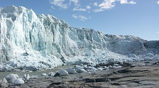
The Aurora Subglacial Basin is largely grounded below sea level, making it susceptible to marine ice sheet instability. The Aurora Subglacial Basin is drained in part by Totten Glacier, which responds readily to melt induced by upwelling of warm circumpolar deep water [1] and could raise global sea level by more than 3.5 m. [2] In 2011 ice-penetrating radar led to the creation of the first high-resolution topographic map of the Basin, one of the last uncharted regions of Earth. The map reveals some of the largest fjords or ice cut channels on Earth, down to more than two kilometres below sea level. [3] [4]

Marine ice sheet instability

Marine ice sheet instability (MISI) describes the potential for ice sheets grounded below sea level to rapidly destabilize in a runaway fashion. The mechanism was first proposed in the 1970s and was quickly identified as a means by which even gradual anthropogenic warming could lead to rapid sea level rise. In Antarctica, the West Antarctic Ice Sheet, the Aurora Subglacial Basin, and the Wilkes Basin are each grounded below sea level and are inherently subject to MISI.

Totten Glacier

Totten Glacier is a large glacier draining a major portion of the East Antarctic Ice Sheet, through the Budd Coast of Wilkes Land in the Australian Antarctic Territory. The catchment drained by the glacier is estimated at 538,000 km2 (208,000 sq mi), extending approximately 1,100 km (680 mi) into the interior and holds the potential to raise sea level by at least 3.5 m (11 ft). Totten drains northeastward from the continental ice but turns northwestward at the coast where it terminates in a prominent tongue close east of Cape Waldron. It was first delineated from aerial photographs taken by USN Operation Highjump (1946–47), and named by Advisory Committee on Antarctic Names (US-ACAN) for George M. Totten, midshipman on USS Vincennes of the United States Exploring Expedition (1838–42), who assisted Lieutenant Charles Wilkes with correction of the survey data obtained by the expedition.

Upwelling The replacement by deep water moving upwards of surface water driven offshore by wind

Upwelling is an oceanographic phenomenon that involves wind-driven motion of dense, cooler, and usually nutrient-rich water towards the ocean surface, replacing the warmer, usually nutrient-depleted surface water. The nutrient-rich upwelled water stimulates the growth and reproduction of primary producers such as phytoplankton. Due to the biomass of phytoplankton and presence of cool water in these regions, upwelling zones can be identified by cool sea surface temperatures (SST) and high concentrations of chlorophyll-a.

Coordinates: 74°S114°E / 74°S 114°E / -74; 114

Related Research Articles

Ice shelf floating platform of ice on the ocean surface, at outlet of a glacier or ice sheet

An ice shelf is a thick suspended platform of ice that forms where a glacier or ice sheet flows down to a coastline and onto the ocean surface. Ice shelves are only found in Antarctica, Greenland, Canada, and the Russian Arctic. The boundary between the floating ice shelf and the anchor ice that feeds it is called the grounding line. The thickness of ice shelves can range from about 100 m (330 ft) to 1,000 m (3,300 ft).

Amundsen Sea An arm of the Southern Ocean off Marie Byrd Land in western Antarctica between Cape Flying Fish to the east and Cape Dart on Siple Island to the west

The Amundsen Sea, an arm of the Southern Ocean off Marie Byrd Land in western Antarctica, lies between Cape Flying Fish to the east and Cape Dart on Siple Island to the west. Cape Flying Fish marks the boundary between the Amundsen Sea and the Bellingshausen Sea. West of Cape Dart there is no named marginal sea of the Southern Ocean between the Amundsen and Ross Seas. The Norwegian expedition of 1928–1929 under Captain Nils Larsen named the body of water for the Norwegian polar explorer Roald Amundsen while exploring this area in February 1929.

Antarctic ice sheet polar ice cap

The Antarctic ice sheet is one of the two polar ice caps of the Earth. It covers about 98% of the Antarctic continent and is the largest single mass of ice on Earth. It covers an area of almost 14 million square kilometres and contains 26.5 million cubic kilometres of ice. A cubic kilometer of ice weighs approximately one metric gigaton, meaning that the ice sheet weighs 26,500,000 gigatons. Approximately 61 percent of all fresh water on the Earth is held in the Antarctic ice sheet, an amount equivalent to about 58 m of sea-level rise. In East Antarctica, the ice sheet rests on a major land mass, while in West Antarctica the bed can extend to more than 2,500 m below sea level.

The Antarctic oscillation is a low-frequency mode of atmospheric variability of the southern hemisphere. It is also known as the Southern Annular Mode (SAM). It is defined as a belt of westerly winds or low pressure surrounding Antarctica which moves north or south as its mode of variability. In its positive phase, the westerly wind belt that drives the Antarctic Circumpolar Current intensifies and contracts towards Antarctica, while its negative phase involves this belt moving towards the Equator. Winds associated with the Southern Annular Mode cause oceanic upwelling of warm circumpolar deep water along the Antarctic continental shelf, which has been linked to ice shelf basal melt, representing a possible wind-driven mechanism that could destabilize large portions of the Antarctic Ice Sheet.

Subglacial lake A lake under a glacier

A subglacial lake is a lake under a glacier, typically an ice cap or ice sheet. There are many such lakes, with Lake Vostok in Antarctica being by far the largest known on Earth at present.

Pine Island Glacier glacier

Pine Island Glacier (PIG) is a large ice stream, and the fastest melting glacier in Antarctica, responsible for about 25% of Antarctica's ice loss. The glacier ice streams flow west-northwest along the south side of the Hudson Mountains into Pine Island Bay, Amundsen Sea, Antarctica. It was mapped by the United States Geological Survey (USGS) from surveys and United States Navy (USN) air photos, 1960–66, and named by the Advisory Committee on Antarctic Names (US-ACAN) in association with Pine Island Bay.

Tunnel valley A U-shaped valley originally cut by water under the glacial ice near the margin of continental ice sheets

A tunnel valley is a large, long, U-shaped valley originally cut under the glacial ice near the margin of continental ice sheets such as that now covering Antarctica and formerly covering portions of all continents during past glacial ages.

West Antarctic Rift

The West Antarctic Rift system (WARS) is a series of rift valleys lying between East and West Antarctica. It encompasses the Ross Embayment, the Ross Sea, the area under the Ross Ice Shelf and a part of Marie Byrd Land in West Antarctica, reaching to the base of the Antarctic Peninsula. It has an estimated length of 3000 km and a width of approximately 700 km. Its evolution is due to lithospheric thinning of an area of Antarctica that resulted in the demarcation of East and West Antarctica. The scale and evolution of the rift system has been compared to that of the Basin and Range Province of the western U.S.

Ice-sheet dynamics

Ice sheet dynamics describe the motion within large bodies of ice, such those currently on Greenland and Antarctica. Ice motion is dominated by the movement of glaciers, whose gravity-driven activity is controlled by two main variable factors: the temperature and strength of their bases. A number of processes alter these two factors, resulting in cyclic surges of activity interspersed with longer periods of inactivity, on both hourly and centennial time scales. Ice-sheet dynamics are of interest in modelling future sea level rise.

Russell Glacier (Greenland) glacier in Greenland

Russell Glacier is a glacier in the Qeqqata municipality in central-western Greenland. It flows from the Greenland ice sheet in the western direction. The front of the glacier is located 25 km (16 mi) east of Kangerlussuaq. It is active, advancing 25 m (82 ft) every year, and due to easy approach it remains a popular tourist target.

Sea level rise The current long-term trend for sea levels to rise mainly in response to global warming.

Since at least the start of the 20th century, the average global sea level has been rising. Between 1900 and 2016, the sea level rose by 16–21 cm (6.3–8.3 in). More precise data gathered from satellite radar measurements reveal an accelerating rise of 7.5 cm (3.0 in) from 1993 to 2017, which is a trend of roughly 30 cm (12 in) per century. This acceleration is due mostly to human-caused global warming, which is driving thermal expansion of seawater and the melting of land-based ice sheets and glaciers. Between 1993 and 2018, thermal expansion of the oceans contributed 42% to sea level rise; the melting of temperate glaciers, 21%; Greenland, 15%; and Antarctica, 8%. Climate scientists expect the rate to further accelerate during the 21st century.

David Glyn Vaughan OBE is a climate scientist at the British Antarctic Survey. His research focus is the role of ice sheets in the Earth system and the societal threat of climate change and rising sea levels. He is a co-ordinating Lead Author of the IPCC Fourth Assessment Report. His research work includes the mapping of the bed under Pine Island Glacier and the discovery of a subglacial volcano.

The Wilkes Basin is a large subglacial basin situated generally southward of George V Coast and westward of Prince Albert Mountains in East Antarctica. The feature is approximately 1400 km long and 400 km wide. The Wilkes Basin is considered to be the largest marine-based drainage basin in East Antarctica, and may be in a state of marine ice sheet instability, caused by warm water intrusion into the shelf cavities.

Overdeepening

Overdeepening is a characteristic of basins and valleys eroded by glaciers. An overdeepened valley profile is often eroded to depths which are hundreds of metres below the deepest continuous line along a valley or watercourse. This phenomenon is observed under modern day glaciers, in salt-water fjords and fresh-water lakes remaining after glaciers melt, as well as in tunnel valleys which are partially or totally filled with sediment. When the channel produced by a glacier is filled with debris, the subsurface geomorphic structure is found to be erosionally cut into bedrock and subsequently filled by sediments. These overdeepened cuts into bedrock structures can reach a depth of several hundred metres below the valley floor.

There are hundreds of antarctic lakes, in Antarctica. In 2018 researchers at the Alfred Wegener Institute's Helmholtz Centre for Polar and Marine Research published a study they claimed cast doubt on earlier estimate that there were almost 400 subglacial antarctic lakes. Antarctica also has some relatively small regions that are clear of ice and snow, and there are some surface lakes in these regions. They called for on the ground seismic studies, or drilling, to determine a more reliable number.

Ice mélange A mixture of sea ice types, icebergs, and snow without a clearly defined floe

Ice mélange refers to a mixture of sea ice types, icebergs, and snow without a clearly defined floe that forms from shearing and fracture at the ice front. Ice mélange is commonly the result of an ice calving event where ice breaks off the edge of a glacier. Ice mélange affects many of the Earth's processes including glacier calving, ocean wave generation and frequency, generation of seismic waves, atmosphere and ocean interactions, and tidewater glacier systems. Ice mélange is possibly the largest granular material on Earth, and is quasi-2-dimensional.

Martin J. Siegert is a British glaciologist, a professor at Imperial College London, and co-director of the Grantham Institute - Climate Change and Environment.

Mercer Lake (Antarctica) Subglacial lake in Antartic Continent

Mercer Subglacial Lake is a subglacial lake in Antarctica covered by a sheet of ice 1,067 m (3,501 ft) thick; the water below is hydraulically active, with water replacement times on the order of a decade from the Ross Sea.

References

  1. Greene, Chad A.; Blankenship, Donald D.; Gwyther, David E.; Silvano, Alessandro; Wijk, Esmee van (2017-11-01). "Wind causes Totten Ice Shelf melt and acceleration". Science Advances. 3 (11): e1701681. doi:10.1126/sciadv.1701681. ISSN   2375-2548. PMC   5665591 . PMID   29109976.
  2. Greenbaum, J. S.; Blankenship, D. D.; Young, D. A.; Richter, T. G.; Roberts, J. L.; Aitken, A. R. A.; Legresy, B.; Schroeder, D. M.; Warner, R. C. (2015-03-16). "Ocean access to a cavity beneath Totten Glacier in East Antarctica". Nature Geoscience. 8 (4): 294–298. doi:10.1038/ngeo2388. ISSN   1752-0894.
  3. New map reveals giant fjords beneath East Antarctic ice sheet
  4. Young, Duncan A.; Wright, Andrew P.; Roberts, Jason L.; Warner, Roland C.; Young, Neal W.; Greenbaum, Jamin S.; Schroeder, Dustin M.; Holt, John W.; Sugden, David E. (2011-06-02). "A dynamic early East Antarctic Ice Sheet suggested by ice-covered fjord landscapes". Nature. 474 (7349): 72–75. doi:10.1038/nature10114. ISSN   0028-0836. PMID   21637255.
United States Geological Survey scientific agency of the United States government

The United States Geological Survey is a scientific agency of the United States government. The scientists of the USGS study the landscape of the United States, its natural resources, and the natural hazards that threaten it. The organization has four major science disciplines, concerning biology, geography, geology, and hydrology. The USGS is a fact-finding research organization with no regulatory responsibility.

Geographic Names Information System geographical database

The Geographic Names Information System (GNIS) is a database that contains name and locative information about more than two million physical and cultural features located throughout the United States of America and its territories. It is a type of gazetteer. GNIS was developed by the United States Geological Survey in cooperation with the United States Board on Geographic Names (BGN) to promote the standardization of feature names.