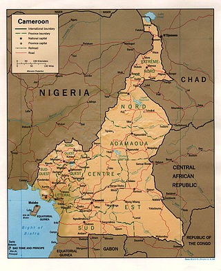
At 475,440 km2 (183,570 sq mi), Cameroon is the world's 53rd largest country. It is slightly larger than the nation of Sweden and the US state of California. It is comparable in size to Papua New Guinea. Cameroon's landmass is 472,710 km2 (182,510 sq mi), with 2,730 km2 (1,050 sq mi) of water.

This article provides a breakdown of the transportation options available in Cameroon. These options are available to citizens and tourists such as railways, roadways, waterways, pipelines, and airlines. These avenues of transport are used by citizens for personal transportation, of goods, and by tourists for both accessing the country and traveling.
Modes of transport in Gabon include rail, road, water, and air. The one rail link, the Trans-Gabon Railway, connects the port of Owendo with the inland town of Franceville. While most of the country is connected by roads, not all areas are accessible. Much of the road network remains unpaved, and it primarily revolves around seven "national routes" labeled N1 through N7. The largest seaports are Port-Gentil and the newer Owendo, and 1,600 km of inland waterways are navigable. There are three international airports, eight other paved airports, and over 40 with unpaved runways. Nearly 300 km of pipelines carry petroleum products, mainly crude oil.

Mining in the engineering discipline is the extraction of minerals from the ground. Mining engineering is associated with many other disciplines, such as mineral processing, exploration, excavation, geology, metallurgy, geotechnical engineering and surveying. A mining engineer may manage any phase of mining operations, from exploration and discovery of the mineral resources, through feasibility study, mine design, development of plans, production and operations to mine closure.

The South Region is located in the southwestern and south-central portion of the Republic of Cameroon. It is bordered to the east by the East Region, to the north by the Centre Region, to the northwest by the Littoral Region, to the west by the Gulf of Guinea, and to the south by the countries of Equatorial Guinea, Gabon, and Congo. The South occupies 47,720 km2 of territory, making it the fourth largest region in the nation. The major ethnic groups are the various Beti-Pahuin peoples, such as the Ewondo, Fang, and Bulu.

The Trans-Gabon Railway is the only railway in Gabon. It runs 670 km (420 mi) east from Owendo port station in Libreville to Franceville via numerous stations, the main ones being Ndjolé, Lopé, Booué, Lastoursville and Moanda.

The Congo–Ocean Railway links the Atlantic port of Pointe-Noire with Brazzaville, a distance of 502 kilometres (312 mi). It bypasses the rapids on the lower Congo River; from Brazzaville, river boats are able to ascend the Congo River and its major tributaries, including the Oubangui River to Bangui.
Belinga is a location in Gabon with as yet unexploited iron ore deposits. These ore deposits extend into neighbouring Cameroon and Congo.
Mbalam is a place in Cameroon near the southern border with the Republic of the Congo where there are significant deposits of iron ore. The mining company is Sundance Resources Limited.
Despite being a mineral rich country, Cameroon has only recently begun to investigate mining on an industrial scale. Strong metal and industrial mineral prices since 2003 have encouraged companies to develop mines here. The terrain mainly consists of granite-rich ground with areas of ultramafic rocks that are sources of cobalt and nickel. There are also deposits of bauxite, gold, iron ore, nepheline syenite, and rutile. Alluvial gold is mainly mined by artisanal miners.
Railway stations in the Republic of the Congo (Congo) include:

The list of railway stations in Cameroon includes:
The mineral industry of Russia is one of the world's leading mineral industries and accounts for a large percentage of the Commonwealth of Independent States' production of a range of mineral products, including metals, industrial minerals, and mineral fuels. In 2005, Russia ranked among the leading world producers or was a significant producer of a vast range of mineral commodities, including aluminum, arsenic, cement, copper, magnesium compounds and metals, nitrogen, palladium, silicon, nickel and vanadium.
The Monts Badondo are a mountain range in northwestern Congo-Brazzaville. Highest peak is 934 m above sea level. They lie close to the border with Gabon and are also not far from the border with Cameroon.
Mauritania's mineral sector was dominated by iron ore mining and beneficiation. Other mineral commodities produced in the country included cement, copper, gold, gypsum, petroleum, salt, and steel. The 'Ministère des Mines et de l’Industrie' was the Government agency responsible for enacting the Mining Code and for the coordination of all activities in the mining sector. The 'Direction des Mines et de la Géologie' was the entity responsible for promoting the mineral sector and for providing geologic and mining information to potential investors; the 'Direction des Hydrocarbures' was in charge of the development of the petroleum sector; and the 'Office Mauritanien des Recherches Géologiques' was the Government entity responsible for evaluating areas of mineral potential for exploration. The 'Société Nationale Industrielle et Minière (SNIM)' was responsible for iron ore production and benefciation.

Sundance Resources Limited is an Australian mining company, based in Perth, Western Australia, whose main assets are iron ore leases in Cameroon near Mbalam, and across the border in the Republic of Congo. Following the loss of the Congo mining licence in 2020, Sundance Resources delisted from the Australian Securities Exchange and sued Congo to acquire $8.76 billion in compensation.

Oil and gas dominate the extraction industries of the Republic of the Congo, also referred to as Congo-Brazzaville. The petroleum industry accounted for 89% of the country’s exports in 2010. Among African crude oil producers in 2010, The Congo ranked seventh. Nearly all of the country's hydrocarbons were produced off-shore. The minerals sector is administered by the Department of Mines and Geology. Presently no major mining activities are underway, although there are some small-scale domestic operations. However, the country does have numerous large-scale undeveloped resources. The country has recently attracted a strong influx of international companies seeking to tap into the vast mineral wealth.
Cominco Resources is a private company which is developing the US$2billion Hinda phosphate project located in The Republic of the Congo. Through its subsidiary it owns 100% of the Hinda Phosphate Project, which comprises the Hinda Permit, and the Kolatchikanou Permit. The Hinda project is the world's largest undeveloped phosphate deposit with a JORC Mineral Resource of 678 Mt and a Minable Ore Reserve of 405 Mt, sufficient for over 24 years of production. Cominco Resources was merged with Kropz in December 2018 and listed on the AIM market.

The mining industry of Liberia has witnessed a revival after the civil war which ended in 2003. Gold, diamonds, and iron ore form the core minerals of the mining sector with a new Mineral Development Policy and Mining Code being put in place to attract foreign investments. In 2013, the mineral sector accounted for 11% of GDP in the country and the World Bank projected a further increase in the sector by 2017.

The geology of the Republic of the Congo, also known as Congo-Brazzaville, to differentiate from the Democratic Republic of the Congo, formerly Zaire, includes extensive igneous and metamorphic basement rock, some up to two billion years old and sedimentary rocks formed within the past 250 million years. Much of the country's geology is hidden by sediments formed in the past 2.5 million years of the Quaternary.