Azimuth compass

Last updated
18th-century azimuthal compass held in the National Archaeological Museum of Spain Brujula azimutal espanola s.XVIII (M.A.N. Madrid) 01.jpg
18th-century azimuthal compass held in the National Archaeological Museum of Spain

An azimuth compass (or azimuthal compass) is a nautical instrument used to measure the magnetic azimuth, the angle of the arc on the horizon between the direction of the Sun or some other celestial object and the magnetic north. This can be compared to the true azimuth obtained by astronomical observation to determine the magnetic declination, the amount by which the reading of a ship's compass must be adjusted to obtain an accurate reading. Azimuth compasses were important in the period before development of the reliable chronometers needed to determine a vessel's exact position from astronomical observations.

Contents

Theory

The azimuth is the angle formed between a reference direction (North) and a line from the observer to a point of interest projected on the same plane as the reference direction Azimuth-Altitude schematic.svg
The azimuth is the angle formed between a reference direction (North) and a line from the observer to a point of interest projected on the same plane as the reference direction

In navigation, the true azimuth of a heavenly body is the arc of the horizon between the point where a vertical plane containing the observer and the heavenly body intersects the horizon and the direction of true north. The magnetic azimuth is the arc between the point on the horizon below the heavenly body and the direction of magnetic north. [1]

When the latitude and date are known, the bearing of the sun at sunrise or sunset relative to true north can be readily determined. [2] If the Sun is observed at some time between sunrise and sunset, its altitude must also be recorded to calculate the true azimuth. The true azimuth may be compared to the magnetic azimuth to find the magnetic declination, the angle between the direction that the compass indicates as north and the true north direction. [3]

Compass designs

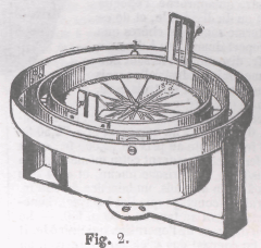
An azimuth compass is a magnetic compass where the circumference of the card is divided into 360 degrees. It has two sights, diametrically opposite each other, through which the Sun, planet or star is viewed. The sun is typically observed when the Sun's center is about one solar diameter above the horizon. [4] [lower-alpha 1] Typically the compass will have a stop in the side of the box, which the observer pushes when the Sun is lined up in the sights. This fixes the compass card, from which the magnetic azimuth or amplitude can be read. [3] [lower-alpha 2]

The sights may consist of two vanes, one with a narrow slit and the other with a wider slit bisected by a thread. The observer looks towards the Sun, seen through a dark glass, lining up the thread and the narrow slit on the center of the Sun. Another arrangement has a vertical bar on one vane and a slit bisected by a thread on the other. The instrument is aligned with the Sun when the shadow of the thread falls on the vertical bar. [3] Yet another design has a magnifying glass on one vane that focuses the rays of the Sun on the opposite vane. [7]

Meridional azimuth compasses included a universal equatorial sundial. By setting the date and latitude, the true north and the magnetic variation could be read from the instrument without the need for calculation. [8] With the iron vessels introduced in the 19th century the azimuth compass would be mounted on a pedestal at a neutral point where the readings would not be affected by magnetism of the vessel. [9]

Applications

A map showing lines of equal magnetic declination in January 2020 World Magnetic Declination 2020.pdf
A map showing lines of equal magnetic declination in January 2020

Early navigators in the northern hemisphere could calculate latitude relatively easily when the night sky was clear by observing the elevation of Polaris, a star that is very close to the north celestial pole. However, calculating longitude was impossible until chronometers that could keep time accurately throughout a long voyage were developed. In 1588 King Philip II of Spain (1556–1598) offered a large reward to anyone who could find a practical solution to determining longitude. [10]

A novel approach, apparently originating with the Jesuit missionary Christoforo Borri, was to create charts that mapped points of equal magnetic declination. [lower-alpha 3] With an accurate reading of the latitude and the magnetic declination the navigator could determine their longitude using the chart. [11] A drawback to this approach is that magnetic variations change over time, so the charts would need constant revision. [12]

The azimuth compass still had great value in letting the master of a ship determine how far the magnetic compass varied from true north, so he could set a more accurate course while following a line of constant latitude or using dead reckoning to navigate. In 1795 a British First Rate ship would have up to eight compasses, of which one was an improved steering compass. This azimuth compass may have been specialized for the purpose of measuring magnetic variation through taking readings from stars, and used to determine the accuracy of the other compasses. [13]

Instruments

An example of an azimuth compass. The visors of unequal height allow sighting of objects above the horizon. Boussole marine.png
An example of an azimuth compass. The visors of unequal height allow sighting of objects above the horizon.

An azimuthal compass was described in 1736, but the inventor was not named. [8] Azimuth compasses were sometimes large, with a brass case mounted in gimbals containing the rose, and sights on top of the case. Walter Hayes, Richard Glynne and Benjamin Ayres (died c. 1775) made accurate large azimuth compasses. [2] Henry Gregory (1744–1782) had an establishment known as "The Azimuth Compass" in Leadenhall Street, London. [14] He supplied an azimuth compass designed by Gowin Knight to Joseph Banks for the voyage of HMS Resolution commanded by Captain James Cook in 1772. [15] The instrument cost £80.0.0. [16]

On 6 February 1808 the American sealer Topaz, commanded by Captain Mayhew Folger, arrived at Pitcairn Island to take on fresh water. There he found thirty-five survivors of the mutiny on HMS Bounty led by John Adams, who gave Folger HMS Bounty's azimuth compass and chronometer. [17]

Related Research Articles

<span class="mw-page-title-main">Longitude</span> Geographic coordinate that specifies the east-west position of a point on the Earths surface

Longitude is a geographic coordinate that specifies the east–west position of a point on the surface of the Earth, or another celestial body. It is an angular measurement, usually expressed in degrees and denoted by the Greek letter lambda (λ). Meridians are imaginary semicircular lines running from pole to pole that connect points with the same longitude. The prime meridian defines 0° longitude; by convention the International Reference Meridian for the Earth passes near the Royal Observatory in Greenwich, south-east London on the island of Great Britain. Positive longitudes are east of the prime meridian, and negative ones are west.

<span class="mw-page-title-main">Navigation</span> Process of monitoring and controlling the movement of a craft or vehicle from one place to another

Navigation is a field of study that focuses on the process of monitoring and controlling the movement of a craft or vehicle from one place to another. The field of navigation includes four general categories: land navigation, marine navigation, aeronautic navigation, and space navigation.

<span class="mw-page-title-main">Compass</span> Instrument used for navigation and orientation

A compass is a device that shows the cardinal directions used for navigation and geographic orientation. It commonly consists of a magnetized needle or other element, such as a compass card or compass rose, which can pivot to align itself with magnetic north. Other methods may be used, including gyroscopes, magnetometers, and GPS receivers.

<span class="mw-page-title-main">Longitude rewards</span> British government prize competition dedicated to building highly accurate chronometers

The longitude rewards were the system of inducement prizes offered by the British government for a simple and practical method for the precise determination of a ship's longitude at sea. The rewards, established through an Act of Parliament in 1714, were administered by the Board of Longitude.

<span class="mw-page-title-main">Celestial navigation</span> Navigation using astronomical objects to determine position

Celestial navigation, also known as astronavigation, is the practice of position fixing using stars and other celestial bodies that enables a navigator to accurately determine their actual current physical position in space or on the surface of the Earth without relying solely on estimated positional calculations, commonly known as "dead reckoning." Celestial navigation is performed without using satellite navigation or other similar modern electronic or digital positioning means.

<span class="mw-page-title-main">Bearing (angle)</span> In navigation, horizontal angle between the direction of an object and another object

In navigation, bearing or azimuth is the horizontal angle between the direction of an object and north or another object. The angle value can be specified in various angular units, such as degrees, mils, or grad. More specifically:

<span class="mw-page-title-main">Magnetic declination</span> Angle on the horizontal plane between magnetic north and true north

Magnetic declination, or magnetic variation, is the angle on the horizontal plane between magnetic north and true north. This angle varies depending on position on the Earth's surface and changes over time.

<span class="mw-page-title-main">Meridian (geography)</span> Line between the poles with the same longitude

In geography and geodesy, a meridian is the locus connecting points of equal longitude, which is the angle east or west of a given prime meridian. In other words, it is a line of longitude. The position of a point along the meridian is given by that longitude and its latitude, measured in angular degrees north or south of the Equator. On a Mercator projection or on a Gall-Peters projection, each meridian is perpendicular to all circles of latitude. A meridian is half of a great circle on Earth's surface. The length of a meridian on a modern ellipsoid model of Earth has been estimated as 20,003.93 km (12,429.87 mi).

<span class="mw-page-title-main">Astrocompass</span> Tool for finding true north through the positions of astronomical bodies

An astrocompass is a navigational tool for determining the direction of true north through the positions of various astronomical bodies.

In astronomical navigation, the intercept method, also known as Marcq St. Hilaire method, is a method of calculating an observer's position on Earth (geopositioning). It was originally called the azimuth intercept method because the process involves drawing a line which intercepts the azimuth line. This name was shortened to intercept method and the intercept distance was shortened to 'intercept'.

<span class="mw-page-title-main">Longitude by chronometer</span>

Longitude by chronometer is a method, in navigation, of determining longitude using a marine chronometer, which was developed by John Harrison during the first half of the eighteenth century. It is an astronomical method of calculating the longitude at which a position line, drawn from a sight by sextant of any celestial body, crosses the observer's assumed latitude. In order to calculate the position line, the time of the sight must be known so that the celestial position i.e. the Greenwich Hour Angle and Declination, of the observed celestial body is known. All that can be derived from a single sight is a single position line, which can be achieved at any time during daylight when both the sea horizon and the sun are visible. To achieve a fix, more than one celestial body and the sea horizon must be visible. This is usually only possible at dawn and dusk.

Ex-meridian is a celestial navigation method of calculating an observer's position on Earth. The method gives the observer a position line on which the observer is situated. It is usually used when the Sun is obscured at noon, and as a result, a meridian altitude is not possible. The navigator measures the altitude of the Sun as close to noon as possible and then calculates where the position line lies.

Meridian altitude is a method of celestial navigation to calculate an observer's latitude. It notes the altitude angle of an astronomical object above the horizon at culmination.

<span class="mw-page-title-main">Lunar distance (navigation)</span> Angular distance between the Moon and another celestial body

In celestial navigation, lunar distance, also called a lunar, is the angular distance between the Moon and another celestial body. The lunar distances method uses this angle and a nautical almanac to calculate Greenwich time if so desired, or by extension any other time. That calculated time can be used in solving a spherical triangle. The theory was first published by Johannes Werner in 1524, before the necessary almanacs had been published. A fuller method was published in 1763 and used until about 1850 when it was superseded by the marine chronometer. A similar method uses the positions of the Galilean moons of Jupiter.

<span class="mw-page-title-main">Marine chronometer</span> Clock used on ships to aid in navigation

A marine chronometer is a precision timepiece that is carried on a ship and employed in the determination of the ship's position by celestial navigation. It is used to determine longitude by comparing Greenwich Mean Time (GMT), and the time at the current location found from observations of celestial bodies. When first developed in the 18th century, it was a major technical achievement, as accurate knowledge of the time over a long sea voyage was vital for effective navigation, lacking electronic or communications aids. The first true chronometer was the life work of one man, John Harrison, spanning 31 years of persistent experimentation and testing that revolutionized naval navigation.

<span class="mw-page-title-main">History of navigation</span> Intersection of history and navigation

The history of navigation, or the history of seafaring, is the art of directing vessels upon the open sea through the establishment of its position and course by means of traditional practice, geometry, astronomy, or special instruments. Many peoples have excelled as seafarers, prominent among them the Austronesians, the Harappans, the Phoenicians, the Iranians, the ancient Greeks, the Romans, the Arabs, the ancient Indians, the Norse, the Chinese, the Venetians, the Genoese, the Hanseatic Germans, the Portuguese, the Spanish, the English, the French, the Dutch, and the Danes.

<span class="mw-page-title-main">History of longitude</span> Record of humanitys attempts to find east-west position on Earth

The history of longitude describes the centuries-long effort by astronomers, cartographers and navigators to discover a means of determining the longitude of any given place on Earth. The measurement of longitude is important to both cartography and navigation. In particular, for safe ocean navigation, knowledge of both latitude and longitude is required, however latitude can be determined with good accuracy with local astronomical observations.

<i>Longitude</i> (book) 1995 popular science book

Longitude: The True Story of a Lone Genius Who Solved the Greatest Scientific Problem of His Time is a best-selling book by Dava Sobel about John Harrison, an 18th-century clockmaker who created the first clock (chronometer) sufficiently accurate to be used to determine longitude at sea—an important development in navigation. The book was made into a television series entitled Longitude. In 1998, The Illustrated Longitude was published, supplementing the earlier text with 180 images of characters, events, instruments, maps and publications.

<span class="mw-page-title-main">History of geomagnetism</span> History of the study of Earths magnetic field

The history of geomagnetism is concerned with the history of the study of Earth's magnetic field. It encompasses the history of navigation using compasses, studies of the prehistoric magnetic field, and applications to plate tectonics.

<span class="mw-page-title-main">Burt's solar compass</span> Surveying instrument that uses the suns direction instead of magnetism

Burt's solar compass or astronomical compass/sun compass is a surveying instrument that makes use of the Sun's direction instead of magnetism. William Austin Burt invented his solar compass in 1835. The solar compass works on the principle that the direction to the Sun at a specified time can be calculated if the position of the observer on the surface of the Earth is known, to a similar precision. The direction can be described in terms of the angle of the Sun relative to the axis of rotation of the planet.

References

Notes

  1. When the lowest part of the Sun is slightly more than half of the Sun's diameter above the horizon, the center of the Sun will in fact lie almost on the horizon. This is due to the refraction of the Sun's rays by the atmosphere. [5]
  2. The magnetic amplitude refers to the arc from the object's projection on the horizon to the magnetic east or west. [6]
  3. Magnetic declination is the angle between true north, the direction of the pole star, and magnetic north as indicated by a magnetic compass.

Citations

Sources