
The Alpine Lakes Wilderness is a large wilderness area spanning the Central Cascades of Washington state in the United States. The wilderness is located in parts of Wenatchee National Forest and Snoqualmie National Forest, and is approximately bounded by Interstate 90 and Snoqualmie Pass to the south and U.S. Route 2 and Stevens Pass to the north. The Alpine Lakes is the largest wilderness area near the population centers of Puget Sound, counted at 414,161 acres (167,605 ha) following the 2014 expansion.

Eagle Cap Wilderness is a wilderness area located in the Wallowa Mountains of northeastern Oregon, within the Wallowa–Whitman National Forest. The wilderness was established in 1940. In 1964, it was included in the National Wilderness Preservation System. A boundary revision in 1972 added 73,000 acres (30,000 ha) and the Wilderness Act of 1964 added 66,100 acres (26,700 ha) resulting in a current total of 361,446 acres, making Eagle Cap by far Oregon's largest wilderness area.
The Foss River is a stream in the U.S. state of Washington. It has two main forks, the East Fork Foss River and the West Fork Foss River. The main stem is formed by the confluence of the two forks. The river and its forks rise near in the Alpine Lakes Wilderness area of Mount Baker-Snoqualmie National Forest in the Cascade Mountains and flows generally north, joining the Tye River to form the South Fork Skykomish River. The Foss River's waters eventually empty into Puget Sound near Everett via the Skykomish River and Snohomish River.

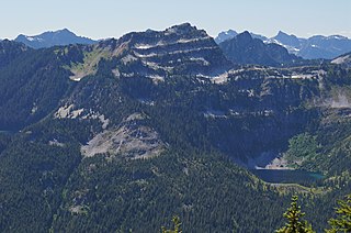
Mount Hinman is located on the border of Snoqualmie and Wenatchee National Forests in the U.S. state of Washington. Mount Hinman is less than 2 mi (3.2 km) west of Mount Daniel and both are within the Alpine Lakes Wilderness. Hinman Glacier is situated on the north flank of Mount Hinman and Foss Glacier is to the northeast. The mountain was named in 1934 for Dr. Harry B. Hinman, a founder of the Everett branch of The Mountaineers club.

Mount Defiance is a 5,584-foot (1,702-metre) mountain summit located in King County of Washington state. It's part of the Cascade Range and is within the Alpine Lakes Wilderness. Mount Defiance is situated 6.5 mi (10.5 km) west of Snoqualmie Pass on land managed by Mount Baker-Snoqualmie National Forest. Precipitation runoff on the mountain drains into tributaries of the Snoqualmie River. The nearest higher peak is Granite Mountain, 3.96 mi (6.37 km) to the east-southeast, and Bandera Mountain is 1.85 mi (2.98 km) to the southeast. Mount Defiance can be reached by trail, with access via the Ira Spring, Talapus Lake, or Pratt Lake trailheads.
Terrace Mountain is a 6,361-foot (1,939-metre) mountain summit located in the Alpine Lakes Wilderness in eastern King County of Washington state. It is part of the Cascade Range and is situated on land managed by Mount Baker-Snoqualmie National Forest. The peak is situated 4 mi (6.4 km) north of Mount Daniel, and is surrounded by Lake Clarice, Marmot Lake, Ptarmigan Lakes, and the Terrace Lakes. Precipitation runoff from the mountain drains into tributaries of the Skykomish River. Topographic relief is significant as the summit rises over 1,800 feet above Lake Clarice in less than one-half mile (0.8 km). The mountain's descriptive name stems from the terrace-like appearance created by a series of benches on its east aspect.

Cathedral Rock 6,724-foot (2,049-metre) mountain located in the Cascade Range, in Kittitas County of Washington state. It is situated within the Alpine Lakes Wilderness, on land managed by Wenatchee National Forest. Its nearest higher peak is The Citadel, 1.7 mi (2.7 km) to the southwest, and the dominant mountain in the area, Mount Daniel, rises 2.2 mi (3.5 km) to the west-northwest. Precipitation runoff from the peak drains into tributaries of the Yakima River.

La Bohn Peak is a 6,585-foot (2,007-metre) mountain summit located two miles north of Dutch Miller Gap, in east King County of Washington state. It is situated at the head of Necklace Valley, in the heart of the Alpine Lakes Wilderness, on land managed by Mount Baker-Snoqualmie National Forest. La Bohn Peak is set west of La Bohn Lakes and La Bohn Gap, and one mile west of the crest of the Cascade Range. Precipitation runoff from the south side of the mountain drains into tributaries of the Snoqualmie River, whereas the north side drains into tributaries of the Foss River. The nearest higher neighbor is Mount Hinman, 1.7 miles (2.7 km) to the east, Little Big Chief Mountain is set 2.3 miles (3.7 km) to the south, and Iron Cap Mountain sits 1.77 miles (2.85 km) to the west.

Iron Cap Mountain is a 6,347-foot (1,935-metre) mountain summit located two miles west-northwest of Dutch Miller Gap, in east King County of Washington state. It is situated in the heart of the Alpine Lakes Wilderness, on land managed by Mount Baker-Snoqualmie National Forest. Iron Cap Mountain is set two miles west of the crest of the Cascade Range. Precipitation runoff from the south side of the mountain drains into tributaries of the Snoqualmie River, whereas the north side drains into tributaries of the Foss River. Although modest in elevation, relief is significant since Iron Cap rises 2,500 feet above the Middle Fork Snoqalmie River Valley in less than one mile. Its neighbors include La Bohn Peak, 1.77 miles (2.85 km) to the east, and Little Big Chief Mountain, 2.14 miles (3.44 km) to the southeast.
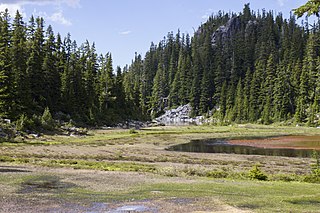
Alturas Lake is a freshwater lake located on the northern slope of Bald Eagle Peak, in King County, Washington. Alturas Lake drains North towards Tonga Ridge and into the East Fork of the Foss River.
Angeline Lake is a freshwater lake located on the northern slope of Iron Cap Mountain between Otter Lake, Azure Lake and Big Heart Lake, in King County, Washington. Self-issued Alpine Lake Wilderness permit required for transit within the Big Snow Mountain area. West Fork Foss River exits Angeline Lake into a canyon that produces Angeline Falls downstream from Chetwoot Lake to Delta Lake. Because Angeline Lake is at the heart of the Alpine Lakes Wilderness, the lake is a popular area for hiking, swimming, and fishing golden trout, rainbow trout, and cutthroat trout.
Chetwoot Lake is a freshwater lake located on the western slope of Iron Cap Mountain next to Crawford Lake, in King County, Washington. West Fork Foss River exits Chetwoot Lake towards Angeline Lake and then to a canyon that produces Angeline Falls downstream towards Delta Lake. Because Chetwoot Lake is at the heart of the Alpine Lakes Wilderness, the lake is a popular area for hiking, swimming, and fishing.
Otter Lake is a freshwater lake located on the western slope of Otter Point northwest of Maple Valley in King County, Washington. Self-issued Alpine Lake Wilderness permit required for transit within the Big Snow Mountain area. Other prominent lakes are west of Otter Lake, including Angeline Lake, Azurite Lake and Big Heart Lake, while Opal Lake and other Necklace Valley lakes are on the eastern slope of Otter Point. Because Otter Lake is at the heart of the Alpine Lakes Wilderness, the lake is a popular area for hiking, swimming, and fishing.
Azurite Lake is a freshwater lake located in the Alpine Lakes Wilderness, between Otter Lake and Angeline Lake in King County, Washington. A short distance south towards Iron Cap Mountain is Azure Lake and Iron Cap Lake. The south shore of the lake rests on a prominent granite ledge up towards a hillock and steep heathland that lead to Iron Cap Mountain. The North shore of the lake is bound by the steep slopes of Saint Agnes Ridge which continue on the eastern slopes of Angeline Lake. Self-issued Alpine Lake Wilderness permit required for transit within the Necklace Valley area.

Iron Cap Lake is a small freshwater lake located in the Alpine Lakes Wilderness, at the south ridge of Azurite Lake and other Necklace Valley lakes in King County, Washington. The lake is nestled on the north skirt of Iron Cap Mountain and produces the West Fork of the Foss River towards Bonnie Lake and contributions from Otter Lake. A short distance towards the West are Crawford Lake and Chetwoot Lake. Self-issued Alpine Lake Wilderness permit required for transit within the Necklace Valley area.
Crawford Lake is a freshwater lake located in the Alpine Lakes Wilderness, at the western ridge of Iron Cap Mountain in King County, Washington. The lake is nestled on a set of prominent valleys and peaks and produces Crawford Creek which flows as one of many tributaries of the Middle Fork Foss River. A short distance towards the north are Chetwoot Lake, Angeline Lake and the Necklace Valley Lakes. Self-issued Alpine Lake Wilderness permit required for transit within the Necklace Valley area.
Bonnie Lake is a small freshwater lake located in the Alpine Lakes Wilderness, south of Otter Lake and the Necklace Valley lakes in King County, Washington. Two waterfalls are found neighboring the lake, one at the eastern inflow and the other at the western outflow: Upper and Lower Bonnie Lake Falls respectively. A short distance towards the South are Iron Cap Mountain and Iron Cap Lake. Bonnie Lake is surrounded by forests except on the eastern side, which is largely composed of vegetated bedrock, talus, and avalanche tracks. Self-issued Alpine Lake Wilderness permit required for transit within the Necklace Valley area.
Delta Lake is a freshwater lake located in the Alpine Lakes Wilderness, north of the Necklace Valley lakes in King County, Washington. Because Delta lake is at the heart of the Alpine Lakes Wilderness, the lake is a popular area for hiking, swimming, and fishing rainbow trout, and cutthroat trout. Delta Lake is a consequence of the spill of the outlets of three major Alpine Lakes: Otter Lake, Big Heart Lake, and Angeline Lake. The West Fork of the Foss River exits Delta Lake in two outlets which merge into one stream shortly above the top of Upper Foss River Falls.

Bald Eagle Lake is a freshwater lake located on the north skirt of Screeching Eagle Peak, a U-shaped ridge massif formed by the junction of Bald Eagle Peak and Silver Eagle Peak, between the West Fork and East Fork of Foss River, in King County, Washington. Other prominent lakes are south of Bald Eagle Lake, including Locket Lake, Otter Lake and Lake Iiswoot, Opal Lake and other Necklace Valley lakes on the eastern slope of Otter Point. Mount Hinman and Mount Daniel are a short distance southeast. Because Bald Eagle Lake is at the heart of the Alpine Lakes Wilderness, the lake is a popular area for hiking, swimming, and fishing.
Island Lakes are a set of closely related freshwater lakes located on a prominent valley at the western base of Pratt Mountain, between Mount Defiance and Bandera Mountain, in King County, Washington. They include Island Lake proper, Rainbow Lake and Blazer Lake. They are themselves surrounded by other alpine lakes, including Lake Kulla Kulla and Mason Lake on the west side of the valley. Because of its proximity to Snoqualmie Pass and other prominent peaks in the Alpine Lakes Wilderness, the lakes are a popular area for hiking, swimming, and fishing rainbow trout. Access to Island Lakes is through Mount Defiance Trail 1009, which is an offshoot of Pratt Lake Trail 1007. The trail passes between Rainbow Lake and Blazer Lake on the north edge.

