
Mount Adams, known by some Native American tribes as Pahto or Klickitat, is a potentially active stratovolcano in the Cascade Range. Although Adams has not erupted in more than 1,000 years, it is not considered extinct. It is the second-highest mountain in Washington, after Mount Rainier.

The Alpine Lakes Wilderness is a large wilderness area spanning the Central Cascades of Washington state in the United States. The wilderness is located in parts of Wenatchee National Forest and Snoqualmie National Forest, and is approximately bounded by Interstate 90 and Snoqualmie Pass to the south and U.S. Route 2 and Stevens Pass to the north. The Alpine Lakes is the largest wilderness area near the population centers of Puget Sound, counted at 414,161 acres (167,605 ha) following the 2014 expansion.
The valley of the West Fork Foss River contains a fair amount of waterfalls. The river heads in a series of large lakes: Big Heart Lake, Angeline Lake, and Otter Lake- which form spectacular waterfalls as they plunge down to Delta Lake. On the valley walls downstream of Delta Lake, are found even more waterfalls.
The Foss River is a stream in the U.S. state of Washington. It has two main forks, the East Fork Foss River and the West Fork Foss River. The main stem is formed by the confluence of the two forks. The river and its forks rise near in the Alpine Lakes Wilderness area of Mount Baker-Snoqualmie National Forest in the Cascade Mountains and flows generally north, joining the Tye River to form the South Fork Skykomish River. The Foss River's waters eventually empty into Puget Sound near Everett via the Skykomish River and Snohomish River.
Big Heart Lake is the most remote and highest-elevation on-trail lake in the West Fork Foss River system. It is a 14.6-mile (23.5 km) round-trip hike from the trailhead, just off of the Foss River Road. The lake is located at the eastern base of Camp Robber Peak in the Alpine Lakes Wilderness Area, within King County, Washington.
Waptus Lake is an alpine freshwater lake located on the southern stretch of the Okanogan–Wenatchee National Forest in Kittitas County, Washington. Because of its proximity to Cooper Lake and the Pacific Crest Trail, Waptus Lake is a popular area for hiking, camping and fishing. Waptus Lake is surrounded by trails that lead to other Alpine lakes in the vicinity, including the Pete Lake and Spectacle Lake at the base of Chikamin Peak.
Lake Augusta is a freshwater lake located on the southwest skirt of Big Jim Mountain, East of Icicle Ridge, in Chelan County, Washington. Because of its close proximity to Icicle Ridge Trail, the lake is a popular area for hiking, swimming, and fishing cutthroat trout. Smaller Lake Ida is a short distance on the opposite side of Icicle Ridge and Big Jim Mountain Lakes or on the northeast slope of the mountain. Lake Augusta is located approximately 15 miles west of the city of Leavenworth. Self-issued Alpine Lake Wilderness permit required for transit within the Lake Augusta area.
Lake Ida is a freshwater lake located along Icicle Ridge, approximately 10 miles west of the city of Leavenworth in Chelan County, Washington. Because of its close proximity to Icicle Ridge Trail, the lake is a popular area for hiking, swimming, and fishing cutthroat trout. Lake Augusta is a short distance on the opposite side of Icicle Ridge. Lake Ida sits on a highly glaciated alpine cirque, surrounded by a coniferous forest primarily larch pines and outflows into Ida Creek, a tributary of Icicle Creek. At least one unrated waterfall is found downstream as Ida Creek runs the south slope of Icicle Ridge. Self-issued Alpine Lake Wilderness permit required for transit within the Lake Ida and Augusta area.

Lake Edna is a freshwater lake located along Icicle Ridge, approximately 10 miles west of the city of Leavenworth in Chelan County, Washington. Because of its close proximity to Icicle Ridge Trail, the lake is a popular area for hiking, swimming, and fishing. Lake Alice is a short distance in a prominent cirque on the opposite side of Icicle Ridge.
Chetwoot Lake is a freshwater lake located on the western slope of Iron Cap Mountain next to Crawford Lake, in King County, Washington. West Fork Foss River exits Chetwoot Lake towards Angeline Lake and then to a canyon that produces Angeline Falls downstream towards Delta Lake. Because Chetwoot Lake is at the heart of the Alpine Lakes Wilderness, the lake is a popular area for hiking, swimming, and fishing.
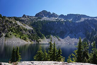
Avalanche Lake is a small alpine freshwater lake located on the northern skirt of Chikamin Peak and Lemah Mountain in King County, Washington. Because of its proximity to surrounding peaks and mountains at the heart of the Alpine Lakes Wilderness, the lake is a popular area for hiking. Other Alpine lakes are in the vicinity, including the Iceberg Lake a short distance East, at the base of Chimney Rock West. To the South is Chikamin Lake.

Spectacle Lake is an alpine freshwater lake located on the northern skirt of Chikamin Peak and Lemah Mountain in Kittitas County on its western border with King County, Washington. Because of its proximity to surrounding peaks and mountains at the heart of the Alpine Lakes Wilderness, the lake is a popular area for hiking, camping and fishing cutthroat trout. Other Alpine lakes are in the vicinity, including the Chikamin Lake, a short distance North, at the base of Chikamin Peak. To the South is Hibox Mountain.
Glacier Lake is a small alpine freshwater lake located on the northern skirt of Chikamin Peak and Lemah Mountain in Kittitas County, Washington. Because of its proximity to surrounding peaks and mountains at the heart of the Alpine Lakes Wilderness, the lake is a popular area for hiking, camping, and fishing golden trout. Glacier Lake is a short distance between Chikamin Lake and Spectacle Lake at the base of Chikamin Ridge. The Pacific Crest Trail is a short distance from Glacier Lake as well as other Alpine lakes located in the vicinity. To the North is Avalanche Lake and Iceberg Lake at the base of Lemah Mountain.
Opal Lake, also known as Necklace Valley Lake 3, is a freshwater lake located on the western region of the Alpine Lakes Wilderness, in King County, Washington. The lake is connected by stream to Emerald Lake and Jade Lake, which form together the Neckelace Valley Lakes. Opal Lake and its surrounding lakes and peaks are a popular area for hiking, swimming, and fishing Rainbow trout. Self-issued Alpine Lake Wilderness permit required for transit within the Necklace Valley area.
Otter Lake is a freshwater lake located on the western slope of Otter Point northwest of Maple Valley in King County, Washington. Self-issued Alpine Lake Wilderness permit required for transit within the Big Snow Mountain area. Other prominent lakes are west of Otter Lake, including Angeline Lake, Azurite Lake and Big Heart Lake, while Opal Lake and other Necklace Valley lakes are on the eastern slope of Otter Point. Because Otter Lake is at the heart of the Alpine Lakes Wilderness, the lake is a popular area for hiking, swimming, and fishing.
Crawford Lake is a freshwater lake located in the Alpine Lakes Wilderness, at the western ridge of Iron Cap Mountain in King County, Washington. The lake is nestled on a set of prominent valleys and peaks and produces Crawford Creek which flows as one of many tributaries of the Middle Fork Foss River. A short distance towards the north are Chetwoot Lake, Angeline Lake and the Necklace Valley Lakes. Self-issued Alpine Lake Wilderness permit required for transit within the Necklace Valley area.
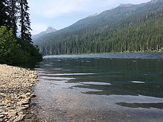
Delta Lake is a freshwater lake located in the Alpine Lakes Wilderness, north of the Necklace Valley lakes in King County, Washington. Because Delta lake is at the heart of the Alpine Lakes Wilderness, the lake is a popular area for hiking, swimming, and fishing rainbow trout, and cutthroat trout. Delta Lake is a consequence of the spill of the outlets of three major Alpine Lakes: Otter Lake, Big Heart Lake, and Angeline Lake. The West Fork of the Foss River exits Delta Lake in two outlets which merge into one stream shortly above the top of Upper Foss River Falls.
Myrtle Lake is a freshwater lake located on the northern slope of Big Snow Mountain between Snoqualmie Lake and Chetwoot Lake, in King County, Washington. Self-issued Alpine Lake Wilderness permit required for transit within the Big Snow Mountain area. Because Myrtle Lake is at the heart of the Alpine Lakes Wilderness, the lake is a popular area for hiking, swimming, and fishing rainbow trout and coastal cutthroat trout.
Snoqualmie Lake Potholes is a set of freshwater lakes located southeast Snoqualmie Lake, in King County, Washington. Self-issued Alpine Lake Wilderness permit required for transit within the Big Snow Mountain area. Because Snoqualmie Lake Potholes are at the heart of the Alpine Lakes Wilderness, the lake is a popular area for hiking, swimming, and fishing rainbow trout and cutthroat trout.
Gold Lake is a freshwater lake located on a valley on the west skirt of Wild Goat Peak, in King County, Washington. Gold Lake is surrounded by prominent peaks and lakes at the heart of the Alpine Lakes Wilderness, including Big Snow Mountain and Iron Cap Mountain.

