
Łojew is a village in the administrative district of Gmina Łochów, within Węgrów County, Masovian Voivodeship, in east-central Poland. It lies approximately 4 kilometres (2 mi) north-east of Łochów, 25 km (16 mi) north-west of Węgrów, and 63 km (39 mi) north-east of Warsaw.

Kijewo is a village in the administrative district of Gmina Gniewkowo, within Inowrocław County, Kuyavian-Pomeranian Voivodeship, in north-central Poland. It lies approximately 8 kilometres (5 mi) south-east of Gniewkowo, 20 km (12 mi) north-east of Inowrocław, and 20 km (12 mi) south of Toruń.
Błażejewice is a village in the administrative district of Gmina Biała Rawska, within Rawa County, Łódź Voivodeship, in central Poland. It lies approximately 8 kilometres (5 mi) north of Biała Rawska, 22 km (14 mi) north-east of Rawa Mazowiecka, and 73 km (45 mi) east of the regional capital Łódź.
Górki Borze is a village in the administrative district of Gmina Korytnica, within Węgrów County, Masovian Voivodeship, in east-central Poland. It lies approximately 4 kilometres (2 mi) north of Korytnica, 13 km (8 mi) north-west of Węgrów, and 64 km (40 mi) north-east of Warsaw.
Jaczew is a village in the administrative district of Gmina Korytnica, within Węgrów County, Masovian Voivodeship, in east-central Poland. It lies approximately 6 kilometres (4 mi) north of Korytnica, 15 km (9 mi) north-west of Węgrów, and 64 km (40 mi) north-east of Warsaw.
Kąty is a village in the administrative district of Gmina Korytnica, within Węgrów County, Masovian Voivodeship, in east-central Poland. It lies approximately 8 kilometres (5 mi) north-west of Korytnica, 19 km (12 mi) north-west of Węgrów, and 60 km (37 mi) north-east of Warsaw.
Komory is a village in the administrative district of Gmina Korytnica, within Węgrów County, Masovian Voivodeship, in east-central Poland. It lies approximately 3 kilometres (2 mi) north-west of Korytnica, 13 km (8 mi) west of Węgrów, and 62 km (39 mi) north-east of Warsaw.
Lipniki is a village in the administrative district of Gmina Korytnica, within Węgrów County, Masovian Voivodeship, in east-central Poland. It lies approximately 4 kilometres (2 mi) north-west of Korytnica, 16 km (10 mi) west of Węgrów, and 60 km (37 mi) north-east of Warsaw.
Maksymilianów is a village in the administrative district of Gmina Korytnica, within Węgrów County, Masovian Voivodeship, in east-central Poland. It lies approximately 7 kilometres (4 mi) north-west of Korytnica, 18 km (11 mi) west of Węgrów, and 59 km (37 mi) north-east of Warsaw.
Barchów is a village in the administrative district of Gmina Łochów, within Węgrów County, Masovian Voivodeship, in east-central Poland. It lies approximately 5 kilometres (3 mi) west of Łochów, 29 km (18 mi) north-west of Węgrów, and 56 km (35 mi) north-east of Warsaw.

Kalinowiec is a village in the administrative district of Gmina Łochów, within Węgrów County, Masovian Voivodeship, in east-central Poland. It lies approximately 11 kilometres (7 mi) south-east of Łochów, 15 km (9 mi) north-west of Węgrów, and 65 km (40 mi) north-east of Warsaw.
Łopianka is a village in the administrative district of Gmina Łochów, within Węgrów County, Masovian Voivodeship, in east-central Poland. It lies approximately 3 kilometres (2 mi) north-east of Łochów, 26 km (16 mi) north-west of Węgrów, and 63 km (39 mi) north-east of Warsaw.
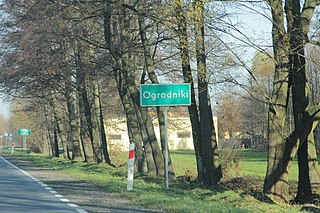
Ogrodniki is a village in the administrative district of Gmina Łochów, within Węgrów County, Masovian Voivodeship, in east-central Poland. It lies approximately 6 kilometres (4 mi) north-east of Łochów, 26 km (16 mi) north-west of Węgrów, and 65 km (40 mi) north-east of Warsaw.
Zagrodniki is a village in the administrative district of Gmina Łochów, within Węgrów County, Masovian Voivodeship, in east-central Poland. It lies approximately 9 kilometres (6 mi) north-east of Łochów, 26 km (16 mi) north-west of Węgrów, and 68 km (42 mi) north-east of Warsaw.
Kozołupy is a village in the administrative district of Gmina Stoczek, within Węgrów County, Masovian Voivodeship, in east-central Poland. It lies approximately 14 kilometres (9 mi) north of Węgrów and 74 km (46 mi) north-east of Warsaw.
Zgrzebichy is a village in the administrative district of Gmina Stoczek, within Węgrów County, Masovian Voivodeship, in east-central Poland. It lies approximately 17 kilometres (11 mi) north-west of Węgrów and 68 km (42 mi) north-east of Warsaw.

Soboń is a village in the administrative district of Gmina Wierzbno, within Węgrów County, Masovian Voivodeship, in east-central Poland. It lies approximately 14 kilometres (9 mi) south-west of Węgrów and 61 km (38 mi) east of Warsaw.
Turna is a village in the administrative district of Gmina Korytnica, within Węgrów County, Masovian Voivodeship, in east-central Poland. It lies approximately 6 kilometres (4 mi) north-east of Korytnica, 9 km (6 mi) north-west of Węgrów, and 68 km (42 mi) north-east of Warsaw.
Ostrowite Prymasowskie is a village in the administrative district of Gmina Witkowo, within Gniezno County, Greater Poland Voivodeship, in west-central Poland. It lies approximately 11 kilometres (7 mi) north-east of Witkowo, 19 km (12 mi) east of Gniezno, and 66 km (41 mi) east of the regional capital Poznań.
Sapieżyn is a village in the administrative district of Gmina Koźmin Wielkopolski, within Krotoszyn County, Greater Poland Voivodeship, in west-central Poland. It lies approximately 7 kilometres (4 mi) north-east of Koźmin Wielkopolski, 22 km (14 mi) north of Krotoszyn, and 72 km (45 mi) south-east of the regional capital Poznań.


