Gmina Stoczek

Last updated
Gmina Stoczek
Stoczek Commune
Gmina
POL gmina Stoczek COA.svg
Coat of arms
Coordinates(Stoczek): 52°33′N21°55′E / 52.550°N 21.917°E / 52.550; 21.917
CountryFlag of Poland.svg  Poland
Voivodeship Masovian
County Węgrów
Seat Stoczek
Area
  Total 144.31 km2 (55.72 sq mi)
Population (2013 [1] )
  Total 5,176
  Density 36/km2 (93/sq mi)
Website http://www.stoczek.net.pl

Gmina Stoczek is a rural gmina (administrative district) in Węgrów County, Masovian Voivodeship, in east-central Poland. Its seat is the village of Stoczek, which lies approximately 18 kilometres (11 mi) north-west of Węgrów and 70 km (43 mi) north-east of Warsaw.

Gmina administrative division of Poland

The gmina is the principal unit of the administrative division of Poland, similar to a municipality. As of 2010 there were 2,478 gminy throughout the country. The word gmina derives from the German word Gemeinde, meaning "community".

Węgrów County County in Masovian, Poland

Węgrów County is a unit of territorial administration and local government (powiat) in Masovian Voivodeship, east-central Poland. It came into being on January 1, 1999, as a result of the Polish local government reforms passed in 1998. Its administrative seat and largest town is Węgrów, which lies 73 kilometres (45 mi) east of Warsaw. The only other town in the county is Łochów, lying 26 km (16 mi) north-west of Węgrów.

Masovian Voivodeship Voivodeship in Poland

Mazovian Voivodeship or Mazovia Province is the largest and most populous of the 16 Polish provinces, or voivodeships, created in 1999. It occupies 35,579 square kilometres (13,737 sq mi) of east-central Poland, and has 5,324,500 inhabitants. Its principal cities are Warsaw in the centre of the Warsaw metropolitan area, Radom (226,000) in the south, Płock (127,000) in the west, Siedlce (77,000) in the east, and Ostrołęka (55,000) in the north. The capital of the voivodeship is the national capital, Warsaw.

Contents

The gmina covers an area of 144.31 square kilometres (55.7 sq mi), and as of 2006 its total population is 5,267 (5,176 in 2013).

Villages

Gmina Stoczek contains the villages and settlements of Błotki, Brzózka, Drgicz, Gajówka Wschodnia, Gajówka Zachodnia, Grabowiec, Gruszczyno, Grygrów, Huta Gruszczyno, Kalaty, Kałęczyn, Kazimierzów, Kozołupy, Majdan, Marianów, Miednik, Mrozowa Wola, Nowe Lipki, Polkowo, Stare Lipki, Stoczek, Topór, Wieliczna, Zgrzebichy and Żulin.

Błotki Village in Masovian, Poland

Błotki is a village in the administrative district of Gmina Stoczek, within Węgrów County, Masovian Voivodeship, in east-central Poland. It lies approximately 17 kilometres (11 mi) north-west of Węgrów and 68 km (42 mi) north-east of Warsaw.

Brzózka, Masovian Voivodeship Village in Masovian, Poland

Brzózka is a village in the administrative district of Gmina Stoczek, within Węgrów County, Masovian Voivodeship, in east-central Poland. It lies approximately 22 kilometres (14 mi) north of Węgrów and 75 km (47 mi) north-east of Warsaw.

Drgicz Village in Masovian, Poland

Drgicz is a village in the administrative district of Gmina Stoczek, within Węgrów County, Masovian Voivodeship, in east-central Poland. It lies approximately 18 kilometres (11 mi) north-west of Węgrów and 70 km (43 mi) north-east of Warsaw.

Neighbouring gminas

Gmina Stoczek is bordered by the gminas of Korytnica, Kosów Lacki, Liw, Łochów, Miedzna and Sadowne.

Gmina Korytnica is a rural gmina in Węgrów County, Masovian Voivodeship, in east-central Poland. Its seat is the village of Korytnica, which lies approximately 11 kilometres west of Węgrów and 60 km north-east of Warsaw.

Gmina Kosów Lacki is an urban-rural gmina in Sokołów County, Masovian Voivodeship, in east-central Poland. Its seat is the town of Kosów Lacki, which lies approximately 23 kilometres (14 mi) north of Sokołów Podlaski and 89 km (55 mi) north-east of Warsaw.

Gmina Liw Gmina in Masovian, Poland

Gmina Liw is a rural gmina in Węgrów County, Masovian Voivodeship, in east-central Poland. It takes its name from the village of Liw. The administrative seat of the gmina is the town of Węgrów, although the town is not part of the territory of the gmina.

Related Research Articles

Gajówka Zachodnia is a village in the administrative district of Gmina Stoczek, within Węgrów County, Masovian Voivodeship, in east-central Poland.

Grabowiec, Węgrów County Village in Masovian, Poland

Grabowiec is a village in the administrative district of Gmina Stoczek, within Węgrów County, Masovian Voivodeship, in east-central Poland. It lies approximately 8 kilometres (5 mi) west of Stoczek, 23 km (14 mi) north-west of Węgrów, and 68 km (42 mi) north-east of Warsaw.

Gruszczyno Village in Masovian, Poland

Gruszczyno is a village in the administrative district of Gmina Stoczek, within Węgrów County, Masovian Voivodeship, in east-central Poland. It lies approximately 8 kilometres (5 mi) south of Stoczek, 13 km (8 mi) north-west of Węgrów, and 68 km (42 mi) north-east of Warsaw.

Grygrów Village in Masovian, Poland

Grygrów is a village in the administrative district of Gmina Stoczek, within Węgrów County, Masovian Voivodeship, in east-central Poland. It lies approximately 7 kilometres (4 mi) south-west of Stoczek, 16 km (10 mi) north-west of Węgrów, and 67 km (42 mi) north-east of Warsaw.

Huta Gruszczyno Village in Masovian, Poland

Huta Gruszczyno is a village in the administrative district of Gmina Stoczek, within Węgrów County, Masovian Voivodeship, in east-central Poland. It lies approximately 14 kilometres (9 mi) north-west of Węgrów and 69 km (43 mi) north-east of Warsaw.

Kałęczyn, Węgrów County Village in Masovian, Poland

Kałęczyn is a village in the administrative district of Gmina Stoczek, within Węgrów County, Masovian Voivodeship, in east-central Poland. It lies approximately 6 kilometres (4 mi) south-east of Stoczek, 14 km (9 mi) north of Węgrów, and 74 km (46 mi) north-east of Warsaw.

Kazimierzów, Gmina Stoczek Village in Masovian, Poland

Kazimierzów is a village in the administrative district of Gmina Stoczek, within Węgrów County, Masovian Voivodeship, in east-central Poland. It lies approximately 11 kilometres (7 mi) north of Węgrów and 73 km (45 mi) north-east of Warsaw.

Kozołupy Village in Masovian, Poland

Kozołupy is a village in the administrative district of Gmina Stoczek, within Węgrów County, Masovian Voivodeship, in east-central Poland. It lies approximately 14 kilometres (9 mi) north of Węgrów and 74 km (46 mi) north-east of Warsaw.

Marianów, Węgrów County Village in Masovian, Poland

Marianów is a village in the administrative district of Gmina Stoczek, within Węgrów County, Masovian Voivodeship, in east-central Poland. It lies approximately 7 kilometres (4 mi) west of Stoczek, 20 km (12 mi) north-west of Węgrów, and 67 km (42 mi) north-east of Warsaw.

Miednik, Masovian Voivodeship Village in Masovian, Poland

Miednik is a village in the administrative district of Gmina Stoczek, within Węgrów County, Masovian Voivodeship, in east-central Poland. It lies approximately 3 kilometres (2 mi) south-east of Stoczek, 16 km (10 mi) north of Węgrów, and 74 km (46 mi) north-east of Warsaw.

Mrozowa Wola Village in Masovian, Poland

Mrozowa Wola is a village in the administrative district of Gmina Stoczek, within Węgrów County, Masovian Voivodeship, in east-central Poland. It lies approximately 6 kilometres (4 mi) north-west of Stoczek, 23 km (14 mi) north-west of Węgrów, and 72 km (45 mi) north-east of Warsaw.

Nowe Lipki Village in Masovian, Poland

Nowe Lipki is a village in the administrative district of Gmina Stoczek, within Węgrów County, Masovian Voivodeship, in east-central Poland. It lies approximately 21 kilometres (13 mi) north of Węgrów and 78 km (48 mi) north-east of Warsaw.

Stare Lipki Village in Masovian, Poland

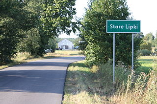
Stare Lipki is a village in the administrative district of Gmina Stoczek, within Węgrów County, Masovian Voivodeship, in east-central Poland. It lies approximately 18 kilometres (11 mi) north of Węgrów and 74 km (46 mi) north-east of Warsaw.

Topór, Węgrów County Village in Masovian, Poland

Topór is a village in the administrative district of Gmina Stoczek, within Węgrów County, Masovian Voivodeship, in east-central Poland. It lies approximately 6 kilometres (4 mi) west of Stoczek, 23 km (14 mi) north-west of Węgrów, and 69 km (43 mi) north-east of Warsaw.

Wieliczna, Masovian Voivodeship Village in Masovian, Poland

Wieliczna is a village in the administrative district of Gmina Stoczek, within Węgrów County, Masovian Voivodeship, in east-central Poland. It lies approximately 7 kilometres (4 mi) west of Stoczek, 22 km (14 mi) north-west of Węgrów, and 67 km (42 mi) north-east of Warsaw.

Zgrzebichy Village in Masovian, Poland

Zgrzebichy is a village in the administrative district of Gmina Stoczek, within Węgrów County, Masovian Voivodeship, in east-central Poland. It lies approximately 17 kilometres (11 mi) north-west of Węgrów and 68 km (42 mi) north-east of Warsaw.

Żulin, Masovian Voivodeship Village in Masovian, Poland

Żulin is a village in the administrative district of Gmina Stoczek, within Węgrów County, Masovian Voivodeship, in east-central Poland. It lies approximately 9 kilometres (6 mi) south-west of Stoczek, 14 km (9 mi) north-west of Węgrów, and 66 km (41 mi) north-east of Warsaw.

References


Coordinates: 52°32′33″N21°53′54″E / 52.54250°N 21.89833°E / 52.54250; 21.89833

Geographic coordinate system Coordinate system

A geographic coordinate system is a coordinate system that enables every location on Earth to be specified by a set of numbers, letters or symbols. The coordinates are often chosen such that one of the numbers represents a vertical position and two or three of the numbers represent a horizontal position; alternatively, a geographic position may be expressed in a combined three-dimensional Cartesian vector. A common choice of coordinates is latitude, longitude and elevation. To specify a location on a plane requires a map projection.