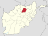
Samangan is one of the thirty-four provinces of Afghanistan, located north of the Hindu Kush mountains in the central part of the country. The province covers 11,218 square kilometres (4,331 sq mi) and is surrounded by Sar-e Pol Province in the west, Balkh in the north, Baghlan in the east, and Bamyan in the south.

Aybak is a provincial town, medieval caravan stop, and the headquarters of the Samangan Province in the district of the same name in the northern part of Afghanistan. As an ancient town and major Buddhist centre during the 4th and 5th centuries under the then Kushan rulers, it has the ruins of that period at a place known now as Takht-i-rustam, which is located on a hill above the town.

Kahmard is a district of Bamyan Province in central Afghanistan. It is located at an altitude of 1,475 meters, with a population of 31,042. Kahmard is situated 140 km from Bamiyan city, in the north of the province, and is divided into five valleys.

Baghlani Jadid is a district of Baghlan Province in northern Afghanistan. It has a population of about 119,607.

Dushi district is located in the central part of Baghlan Province, Afghanistan. It lies on the major Kabul-Kunduz highway. The population of the district was estimated to be around 57,160 in 2004. Hazaras are around 60% of the population and make up the majority in the district, followed by Tajiks (39%). The centre of the district is Dushi. Dushi was considered contested between the Afghan Government and the Taliban in late 2018.
Abdan-e Shebaqli is a small village in Samangan Province, in northern Afghanistan. It is located east of Kholm by road.
Ab Khvorak-e Bala is a small village in Samangan Province, in northern Afghanistan. It is located in the very south of Samangan Province, about 200 miles northwest of Kabul. Several fields are located in the vicinity to provide the locals with food supply in this isolated village.
Ab Khvorak-e Pa'in is a small village in Samangan Province, in northern Afghanistan. It is located in the very south of Samangan Province, about 200 miles northwest of Kabul. Several fields are located in the vicinity to provide the locals with food supply in this isolated village.
Aq Gonbaz is a village in Samangan Province, in northern Afghanistan. It is located in the northern part of Samangan Province and lies in a dry, wide valley. Aq Gonbaz is accessed via a dirt track east of the A76 highway, to the northeast of Hazrat e Soltan.
Balahesar is a village in Samangan Province, in northern Afghanistan. It is located approximately 80 kilometres southwest of Samangan (Aybak).
Band-e Sareq is a village in Samangan Province, in northern Afghanistan. It is located in the western part of Samangan Province, approximately 30 kilometres northeast of Chamchal.
Besh Qol is a village in Samangan Province, in northern Afghanistan. It is located approximately 50 kilometres west of Pol-e-Khomri.
Darah Sof is a district of Samangan Province in Afghanistan. It is located about 130 kilometres (81 mi) from the city of Samangan and 200 kilometres (120 mi) from the city of Mazar-i-Sharif, in Balkh Province.

Samangan is a village in Dughayi Rural District, in the Central District of Quchan County, Razavi Khorasan Province, Iran. At the 2006 census, its population was 19, in 5 families.
Samangan is a village in Karizan Rural District, Nasrabad District, Torbat-e Jam County, Razavi Khorasan Province, Iran. At the 2006 census, its population was 5,173, in 1,136 families.
Samangan is a village in Hasanabad Rural District, in the Central District of Ravansar County, Kermanshah Province, Iran. At the 2006 census, its population was 141, in 29 families.
Samangan-e Olya is a village in Hojr Rural District, in the Central District of Sahneh County, Kermanshah Province, Iran. At the 2006 census, its population was 432, in 109 families.
Samangan-e Sofla is a village in Hojr Rural District, in the Central District of Sahneh County, Kermanshah Province, Iran. At the 2006 census, its population was 212, in 54 families.
Samangan is a village in Dasht-e Laleh Rural District, Asir District, Mohr County, Fars Province, Iran. At the 2006 census, its population was 169, in 35 families.
Samangan University is located in Samangan province, northern Afghanistan.