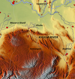
Khulm River

Last updated
Khulm River
Khulm River.png
Location
Country Afghanistan
Physical characteristics
Source 
  locationKara-Kotal pass
  elevation3,600 m (11,800 ft)
Mouth  
  location
Amu Darya River
Length230 km (140 mi)
Basin size8,400 km2 (3,200 sq mi)

The Khulm River (Darya-i Khulm; alternate spelling: Kholm; alternate name: Tashqurghan River) [1] is a river of Northern-Central Afghanistan. In its lower course, it passes through Khulm and Haybak, [2] today in Balkh Province. The Khulm is a tributary to the Oxus basin. [3] Its source is located to the South of the city of Khulm. Further upstream, it passes through the city of Samangan and Samangan Province. The Khulm River forms the western border of Kunduz Province. [3]

Contents

Geography

The mountains are characterized as rocky aridity as they extend from the Koh-i-Baba to Khulm River. On occasion, the landscape turns into trenched valleys engulfed with vegetation. [3] The river rocks are composed of sandstone and limestone. [4]

The Khulm River is one of the tributaries of the Amu Darya River, a major river in Central Asia. It is known as a “blind river” or “natural river” as it dries up due to local use within its basin boundary and does not reach the Amu Darya, except during exceptional high flow years. The Khulm River originates in the Kara-Kotal pass and flows through gorges and then emerges into a wide valley near the Tashkurgan town. The river raising at an elevation of 3,600 m has a total length of about 230 km. It drains a catchment area of 8,400 km2 with the annual runoff estimates varying from 58.2 to 67 million m3 by different assessors. The road between Kabul and Mazar-e-Sharif follows the course of the river. [5] At the junction of the Bamian and Badakhshan routes, the Khulm River emerges from the mountains by the town of Kholm. [6]

The Khulm is used for irrigation entirely before it can reach the Oxus. [3] In 1896, Keane wrote of the countryside's desert encroachment, causing the Khulm River as it passes from the Kara-koh hills to no longer reach the Oxus. [7]

Agriculture

Pistachio farmers near the banks of the Khulm Samangan Province pistacchio farmers.jpg
Pistachio farmers near the banks of the Khulm

The banks of the Khulm River are rich agricultural areas with rolling green hills at the side of the valleys it passes through. Many farmers in this region of Afghanistan are dependent upon the river for agriculture, particularly fruits. The Khulm is said to produce the world's finest Satar Bayee, Khairuddin Bayee and Abdul Wahidi almonds, pistachio nuts and Afghanistan's finest pomegranates. [8]

Flood control

Near Khulm, there are extensive orchards on the banks of the river. [9] IDEA-NEW has been responsible for implementing a new program to prevent the orchards from flooding in Khulm District, protecting some 500 hectares of orchards from floods. [8] The first phase was completed in winter 2009 with the erection of a 975 metre long protection wall and in 2010 550 metre long gabion protection walls were built on both sides of the Khulm River benefiting 500 families. [8] The project has created some 6,900 days of employment for local workers combined and generating an income of US$99,362 for the labourers who were trained in gabion weaving to be implemented along the river banks. [8] Previously the locals living along the river would attempt to mitigate the river against flooding with sandbanks which failed poorly. [8]

Related Research Articles

<span class="mw-page-title-main">Amu Darya</span> River in Central Asia

The Amu Darya is a major river in Central Asia and Afghanistan. Rising in the Pamir Mountains, north of the Hindu Kush, the Amu Darya is formed by the confluence of the Vakhsh and Panj rivers, in the Tigrovaya Balka Nature Reserve on the border between Afghanistan and Tajikistan, and flows from there north-westwards into the southern remnants of the Aral Sea. In its upper course, the river forms part of Afghanistan's northern border with Tajikistan, Uzbekistan, and Turkmenistan. In ancient history, the river was regarded as the boundary of Greater Iran with "Turan", which roughly corresponded to present-day Central Asia. The Amu Darya has a flow of about 70 cubic kilometres per year on average.

<span class="mw-page-title-main">Hindu Kush</span> Mountain range near the border of Afghanistan and Pakistan

The Hindu Kush is an 800-kilometre-long (500 mi) mountain range in Central and South Asia to the west of the Himalayas. It stretches from central and western Afghanistan into northwestern Pakistan and far southeastern Tajikistan. The range forms the western section of the Hindu Kush Himalayan Region (HKH); to the north, near its northeastern end, the Hindu Kush buttresses the Pamir Mountains near the point where the borders of China, Pakistan and Afghanistan meet, after which it runs southwest through Pakistan and into Afghanistan near their border. The eastern end of the Hindu Kush in the north merges with the Karakoram Range. Towards its southern end, it connects with the White Mountains near the Kabul River. It divides the valley of the Amu Darya to the north from the Indus River valley to the south. The range has numerous high snow-capped peaks, with the highest point being Tirich Mir or Terichmir at 7,708 metres (25,289 ft) in the Chitral District of Khyber Pakhtunkhwa, Pakistan.

<span class="mw-page-title-main">Badakhshan</span> Historical region of Central Asia (now part of Afghanistan, Tajikistan, and western China)

Badakhshan is a historical region comprising parts of modern-day north-eastern Afghanistan, eastern Tajikistan, and Taxkorgan Tajik Autonomous County in China. Badakhshan Province is one of the 34 provinces of Afghanistan. Much of historic Badakhshan lies within Tajikistan's Gorno-Badakhshan Autonomous Region in the southeastern part of the country. The music of Badakhshan is an important part of the region's cultural heritage.

<span class="mw-page-title-main">Hazarajat</span> Region in the central highlands of Afghanistan

Hazaristan, or Hazarajat is a mostly mountainous region in the central highlands of Afghanistan, among the Koh-i-Baba mountains in the western extremities of the Hindu Kush. It is the homeland of the Hazara people who make up the majority of its population. Hazarajat denotes an ethnic and religious zone.

Related to 1896 in Afghanistan: Negotiations are going on between the Indian government and the amir tending to the appointment of a joint commission for determining the last 100 miles (160 km) of Indo-Afghan frontier yet unsettled, from Landi Kotal in the Khyber to Nawar Kotal on the Kunar River.

<span class="mw-page-title-main">Balkh Province</span> Province of Afghanistan

Balkh is one of the 34 provinces of Afghanistan, located in the north of the country. It is divided into 15 districts and has a population of about 1,509,183, which is multi-ethnic and mostly a Persian-speaking society. The city of Mazar-i-Sharif serves as the capital of the province. The Mazar-i-Sharif International Airport and Camp Marmal sit on the eastern edge of Mazar-i-Sharif.

<span class="mw-page-title-main">Termez</span> Ancient city in Surxondaryo Region, Uzbekistan

Termez is the capital of Surxondaryo Region in southern Uzbekistan. Administratively, it is a district-level city. Its population is 182,800 (2021). It is notable as the site of Alexander the Great's city Alexandria on the Oxus, as a center of early Buddhism, as a site of Muslim pilgrimage, and as a base of Soviet Union military operations in Afghanistan, accessible via the nearby Hairatan border crossing.

Sheberghān or Shaburghān, also spelled Shebirghan and Shibarghan, is the capital city of the Jowzjan Province in northern Afghanistan.

<span class="mw-page-title-main">Aybak, Samangan</span> Town in Samangan, Afghanistan

Aybak is a provincial town, medieval caravan stop, and the headquarters of the Samangan Province in the district of the same name in the northern part of Afghanistan. As an ancient town and major Buddhist centre during the 4th and 5th centuries under the then Kushan rulers, it has the ruins of that period at a place known now as Takht-i-rustam, which is located on a hill above the town.

<span class="mw-page-title-main">Shortugai</span> Trading colony of the Indus Valley Civilization established around 2000 BC

Shortugai (Shortughai), in Darqad District of northern Afghanistan, was a trading colony of the Indus Valley civilization established around 2000 BC on the Oxus river near the lapis lazuli mines. It is considered to be the northernmost settlement of the Indus Valley Civilization. According to Bernard Sergent, "not one of the standard characteristics of the Harappan cultural complex is missing from it".

<span class="mw-page-title-main">Kushan Pass</span> Mountain pass in northern Afghanistan

The Kushan Pass or Kaoshan Pass is a mountain pass just west of the famous Salang Pass in the Hindu Kush mountain range of northern Afghanistan. These two passes provided the most direct, if difficult, routes across the imposing east–west wall of the Hindu Kush mountains which divide northern Afghanistan or Tokharistan from Kabul province, which is closely connected to southern Afghanistan and Pakistan. Nowadays, the Salang tunnel constructed by the Soviets in the 1960s, and the paved road through it make it by far the easiest route through the Hindu Kush Mountains.

<span class="mw-page-title-main">Kholm, Afghanistan</span> Town in Balkh Province, Afghanistan

Kholm or Khulm, formerly known as Tashqurghan, is a town in Balkh Province of northern Afghanistan, 60 km east of Mazar-i-Sharif one-third of the way to Kunduz. Kholm is an ancient town located on the fertile, inland delta fan of the Khulm River. As such, it is an agriculturally rich locale and densely populated. It is famous for its covered market, and is a centre for trading in sheep and wood. The town was once part of Samangan Province, now in the Khulm District of Balkh.

The Kunduz River is a tributary of the Amu Darya in northern Afghanistan. It rises in Bamyan Province in the Hindu Kush, and in its upper reaches is also known as the Bamyan River or the Surkhab River. After passing through Baghlan Province and Kunduz Province, the Kunduz River merges into the Amu Darya.

Satar Bayee is a variety of almonds, grown mainly in Afghanistan. The river valleys of the Khulm River in northern Afghanistan, particular Balkh Province and Samangan Province grow Satar Bayee almonds in abundance and is said to grow the finest Satar Bayee almonds in the world. Satar Bayee is governed by the Mazar Dried Fruit Association.

Abdul Wahidi or Abdul Bedi is a variety of almonds, grown mainly in Afghanistan. The river valleys of the Khulm River in northern Afghanistan, particularly Balkh province, Samangan province and Kunduz province grow Abdul Wahidi almonds in abundance. Balkh province is said to grow the finest Abdul Wahidi almonds in the world. The Haji Moh area is a known centre of productivity by the Abdul Wahidi firm. Abdul Wahidi nuts are characteristically yellow in color.

Darah Sof was a district of Samangan Province in Afghanistan. It was located about 130 kilometres (81 mi) from the city of Samangan and 200 kilometres (120 mi) from the city of Mazar-i-Sharif, in Balkh Province. In 2005, the district was split into Dara-i Sufi Bala District or Darah Sof Balla District, and Dara-i Sufi Payin District or Darah Sof Payan District.

<span class="mw-page-title-main">Transoxiana</span> Central Asian historical region between the Amu Darya and Syr Darya rivers

Transoxiana or Transoxania is the Latin name for a region and civilization located in lower Central Asia roughly corresponding to modern-day eastern Uzbekistan, western Tajikistan, parts of southern Kazakhstan, parts of Turkmenistan and southern Kyrgyzstan. Geographically, it is the region between the rivers Amu Darya to its south and the Syr Darya to its north.

Asian Highway 76 (AH76) is a major road of northern Afghanistan. It connects Pole khomri at AH7 to Mazar-i-Sharif, passing through Samangan on the way, and then passes west and eventually ends at Herat, where it unites with AH1 and AH77 At Mazar-e-Sharif the road continues and joins the A01 and AH77 highways. Another road passes north from the A76 and connects it to Termiz in southern Uzbekistan. Note though that this "other road" is often regarded as a continuation of the A76, although it is actually part of the historical Pamir Highway, now known as the M41 highway (AH62). This road links Mazar-i-Sharif across the Amu Darya river, to Termiz. The Pamir Highway or the M41 is an extremely important highway of Uzbekistan, Tajikistan and Kyrgyzstan, which connects Termiz to Kara Balta to the west of Bishkek and links with the M39 highway twice at both cities.

Kampir Tepe is an archaeological site located within the Surxondaryo Region of Uzbekistan, near the village Shoʻrob, northwest of the city of Termez. It is thought to be the lost city of Alexandria on the Oxus described by Ptolemy, though the Amu Darya river has now changed its course. The Telegraph newspaper describes Kampir Tepe as “the Pompeii of Central Asia.”

References

  1. Noelle, Christine (1997). State and tribe in nineteenth-century Afghanistan: the reign of Amir Dost Muhammad Khan (1826-1863). Psychology Press. p. 61. ISBN   0-7007-0629-1.
  2. Le Strange, Guy (1905). The Lands of the Eastern Caliphate: Mesopotamia, Persia, and Central Asia, from the Moslem Conquest to the Time of Timur. New York: Barnes & Noble, Inc. p. 427. OCLC   1044046.
  3. 1 2 3 4 Baynes, Thomas Spencer (1888). "Afghanistan". The Encyclopædia Britannica: a dictionary of arts, sciences, and general literature. Vol. 1. H.G. Allen. pp. 242–243.
  4. Society for the Diffusion of Useful Knowledge (Great Britain) (1843). "Turkistan". The Penny cyclopædia of the Society for the Diffusion of Useful Knowledge. Vol. 25. C. Knight. p. 413.
  5. "Water Resource Development In Northern Afghanistan and Its Implications::Working paper 12" (PDF). World Bank. pp. 2, 11–12. Archived from the original (PDF) on 2016-03-03. Retrieved 2010-10-29.
  6. Keane, Augustus Henry (1896). Asia...: Southern and western Asia. E. Stanford. p.  33.
  7. Keane, p. 18
  8. 1 2 3 4 5 "IDEA-NEW protects 500 hectares of orchards from floods in Khulm District of Balkh". USAID. August 15, 2010. Retrieved October 28, 2010.
  9. Wood, John (2001). A Journey to the Source of the River Oxus. With an essay on the geography of the valley of the Oxus by Henry Yule. Elibron.com. p. 266. ISBN   1-4021-0034-5.

Coordinates: 36°45′58″N67°42′09″E / 36.766007°N 67.702446°E / 36.766007; 67.702446