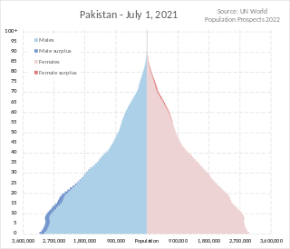
Pakistan had a population of 241,495,112 according to the final results of the 2023 Census. This figure includes Pakistan's four provinces e.g. Punjab, Sindh, KPK, Balochistan and Islamabad Capital Territory. AJK and Gilgit-Baltistan's census data is yet to be approved by CCI Council of Pakistan. Pakistan is the world's fifth most populous country.

The population of Afghanistan is around 43.4 million as of 2024. The nation is composed of a multi-ethnic and multilingual society, reflecting its location astride historic trade and invasion routes between Central Asia, South Asia, and Western Asia. Ethnic groups in the country include Pashtun, Tajik, Hazara, Uzbek, as well as smaller groups such as Baloch, Nuristani, Turkmen, Aimaq, Mongol and some others which are less known. Together they make up the contemporary Afghan people.
Baghlan is one of the 34 provinces of Afghanistan. It is in the north of the country. As of 2020, the province has a population of about 1,014,634.

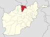
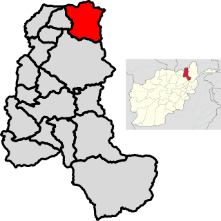
Samangan is one of the thirty-four provinces of Afghanistan, located north of the Hindu Kush mountains in the central part of the country. The province covers 11,218 square kilometres (4,331 sq mi) and is surrounded by Sar-e Pol Province in the west, Balkh in the north, Baghlan in the east, and Bamyan in the south.

The districts of Afghanistan, known as wuleswali, are secondary-level administrative units, one level below provinces. The Afghan government issued its first district map in 1973. It recognized 325 districts, counting wuleswalis (districts), alaqadaries (sub-districts), and markaz-e-wulaiyat. In the ensuing years, additional districts have been added through splits, and some eliminated through merges. In June 2005, the Afghan government issued a map of 398 districts. It was widely adopted by many information management systems, though usually with the addition of Sharak-e-Hayratan for 399 districts in total. It remains the de facto standard as of late 2018, despite a string of government announcements of the creation of new districts.

Gulistan, also spelled as Golestan, is a district in Farah Province, Afghanistan. Its population, which is approximately 55% Pashtun and 45% Tajik, was estimated at 53,780 in October 2004. The district has a total of 109 villages. The main village, also called Gulistan, is situated at 1434 m altitude in the mountainous part of the district. The main road through the district is Route 522.
Nili is a district in Daykundi province in central Afghanistan. The main town in the district, also called Nili, serves as the capital of Daykundi Province. The town of Nili has a small airport (heliport) with a gravel runway and a commercial radio station. The weather conditions in the winter are severe and the roads are difficult.
Almar is a district in the southwestern part of Faryab province, Afghanistan. Its northern border is the national border with Turkmenistan. The population was estimated at 150,000 in 2013. Ethnic diversity includes 35% Turkmen and 65% Pashtun.
Adraskan is a district in the central part of Herat Province in Afghanistan. It is bordered to the west by Iran, to the north by Ghoryan District, Zinda Jan District, Guzara District, Pashtun Zarghun District and Obe District, to the east by Farsi District and to the south by Shindand District.
The Ghurian District is an Afghan administrative district (Wuleswali) in far western Afghanistan in western Herat Province. The district is bordered by Iran to the west and northwest. It is then bordered by other districts of Herat, Kohsan District in the north, Zendeh Jan District to the east, and Adraskan District to the south. The Hari River flows through the northeastern end of the district. The border with Iran is marshy. The population is 85,900 and the district center is the city of Ghurian.
Gulran District is situated in northwestern part of Herat province, Afghanistan and borders Iran to the west, Turkmenistan to the north, Kushk District to the east, and Zinda Jan District and Kohsan District to the south. The population is 91,500 (2012). The district center is the village of Gulran. There are no mountains in the district.

Bangi District is a district of Takhar Province, Afghanistan.
Chah Ab District is a district of Takhar Province, Afghanistan. Its district center is Chah Ab. The district's economy is primarily based on agriculture and livestock.
Yangi Qala District is a district in Takhar Province, Afghanistan. Economically the population of this district is primarily involved in agriculture. The main crops are rice and wheat, and the surplus rice is exporting to neighboring districts and provinces. There are 64 villages in the district. As of August 2021, the Taliban has full control over this district.

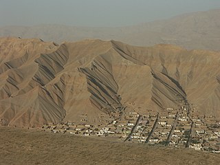
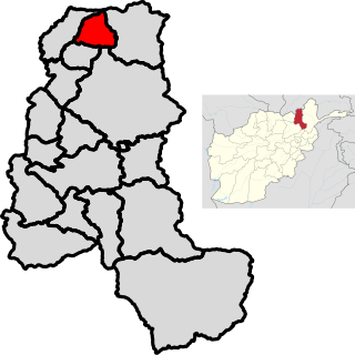
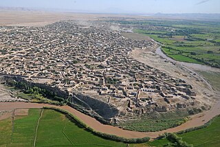
Kholm or Khulm, formerly known as Tashqurghan, is a town in Samangan Province of northern Afghanistan, 60 km east of Mazar-i-Sharif one-third of the way to Kunduz. Kholm is an ancient town located on the fertile, inland delta fan of the Khulm River. As such, it is an agriculturally rich locale and densely populated. It is famous for its covered market, and is a centre for trading in sheep and wood.

Bādghīs is one of the thirty-four provinces of Afghanistan, located in the northwest of the country, on the border with Turkmenistan. It is considered to be one of the country's most underdeveloped provinces, with the highest poverty rate. The capital is Qala e Naw, while the most populous city and the district are Bala Murghab. The ruins of the medieval city of Marw al-Rudh, the historical capital of the medieval region of Gharjistan, are located in the province near the modern city of Bala Murghab.

Janikhel is a district in Paktika Province, in eastern Afghanistan. It was created in 2004 out of a part of Khairkot District.
Khwaja Bahauddin District is a district of Takhar Province, Afghanistan. The district was created from a portion of Yangi Qala District in 2005. 25 villages are located in Khwaja Bahauddin.
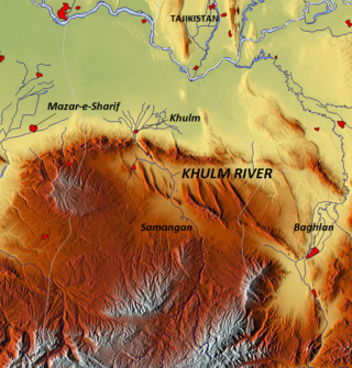
The Khulm River is a river of north-central Afghanistan. In its lower course, it passes through Khulm and Haybak in Balkh Province. The Khulm is a tributary to the Oxus basin. Its source is south of the city of Khulm and it passes through the city of Samangan and Samangan Province. The Khulm River forms the western border of Kunduz Province.