Lake Zürich is a lake in Switzerland, extending southeast of the city of Zürich. Depending on the context, Lake Zürich or Zürichsee can be used to describe the lake as a whole, or just that part of the lake downstream of the Seedamm at Rapperswil, whilst the part upstream of Rapperswil may be called the Obersee or Upper Lake.

The canton of Zürich is a Swiss canton in the northeastern part of the country. With a population of 1,539,275, it is the most populous canton in the country. Its capital is the city of Zürich. The official language is German. The local Swiss German dialect, called Züritüütsch, is commonly spoken. In English the name of the canton and its capital is often written without an umlaut.
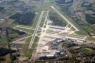
Zurich Airport is the largest international airport of Switzerland and the principal hub of Swiss International Air Lines. It serves Zürich, Switzerland's largest city, and, with its surface transport links, much of the rest of the country. The airport is located 13 kilometres (8 mi) north of central Zürich, in the municipalities of Kloten, Rümlang, Oberglatt, Winkel, and Opfikon, all of which are within the canton of Zürich.

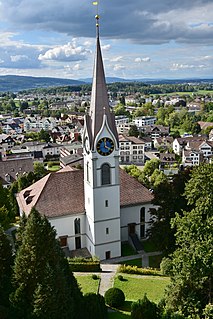
Wetzikon is a small town in the Zurich Highlands area of Switzerland, in the district of Hinwil in the canton of Zürich.

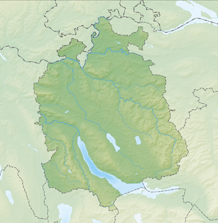
The Zürcher Oberland in Switzerland, is the hilly south-eastern part of the canton of Zurich, bordering on the Toggenburg, including the districts of Uster, Hinwil, Pfäffikon as well as the Töss Valley as far as the district of Winterthur. The territory gradually fell under the control of the city of Zurich from 1408 to 1452. In the 18th century, the jurisdiction lay with the reeve of Grüningen for the southern part, and with the reeve of Kyburg for the northern part together with most of the Zürcher Unterland.

St. Peter is one of the four main churches of the old town of Zürich, Switzerland, besides Grossmünster, Fraumünster, and Predigerkirche.

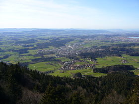
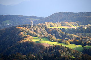
Bachtel Tower is a 60 m (200 ft) tall radio tower on 1,115 m (3,658 ft) high Bachtel mountain near Hinwil, Switzerland, overlooking the Zürcher Oberland. Bachtel Tower is a lattice tower whose observation deck, 30 m (98 ft) metres above the ground, is accessible by a stairway. It was built as replacement for a smaller observation tower on the site in 1986. On the observation deck of Bachtel Tower there is an illustration with the names of the mountains of the Swiss Alps visible. This illustration was designed by Paul Thalmann from Wernetshausen near Hinwil.
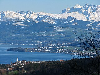
The Au Peninsula is located on the Swiss Zürichsee lake shore in the municipality of Au, Canton of Zürich.

The Jona is a river in the Swiss cantons of Zürich and St. Gallen.
Felsenegg is a vantage point in the canton of Zürich in Switzerland.

Zimmerberg is a mountain and a region located in the district of Horgen in the canton of Zurich, Switzerland. Its name bases on the Old High German word zimbar in the meaning of lumber.

The Adliswil-Felsenegg cable car is a cable car in the canton of Zürich in Switzerland. The lower station is located in Adliswil in the Sihl Valley, whilst the upper station is located on the Felsenegg hill on the Albis ridge near the Felsenegg-Girstel TV-tower. The upper station at Felsenegg forms one end of a panoramic walk to the Uetliberg mountain, whilst the lower station is some 400 metres (1,300 ft) from Adliswil railway station.

Pfannenstiel is a wooded mountain respectively a region overlooking the Lake Zürich and Zürcher Oberland in the canton of Zürich in Switzerland.

Adlisberg, with an elevation of 701 metres (2,300 ft), is a wooded mountain in Switzerland overlooking Zürichsee to the northwest near the Zürichberg.
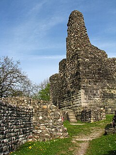
Irgenhausen Castrum is a Roman fort at Irgenhausen, situated on Pfäffikersee lake shore in Switzerland. It was a square fort, measuring 60 metres (197 ft) in square, with four corner towers and three additional towers. The remains of a stone wall in the interior were probably a spa.

The Höhronen is a mountain of the Swiss Prealps, located on the border between the Swiss cantons of Zurich and Zug. It lies approximately halfway between Lake Zurich and Lake Ägeri.

The Grynau Castle is the name of a castle tower in the municipality of Tuggen in the canton of Schwyz, built by the House of Rapperswil in the early 13th century AD.
Alt-Regensberg Castle is a hill castle which was built about the mid-11th century AD by the House of Regensberg in the Swiss municipality of Regensdorf in the Canton of Zürich.

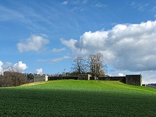
Uster Castle is a hill castle which was built probably around 1200 AD by the House of Rapperswil in the Swiss municipality of Uster in the Canton of Zürich. Since 1995 it houses a boarding school.
Reformierte Kirche Uster is an Evangelical Reformed church in the Swiss municipality of Uster in the Canton of Zürich that was built in 1824. The predecessor St. Andreas church, situated next to the Uster Castle, was given by the House of Rapperswil and first mentioned in 1099 AD.