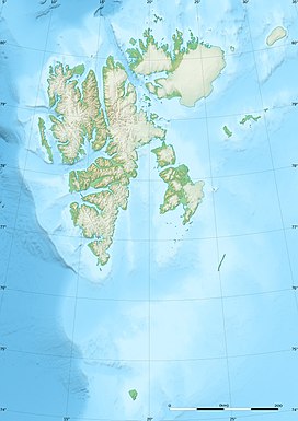
Svalbard, previously known as Spitsbergen or Spitzbergen, is a Norwegian archipelago in the Arctic Ocean. North of mainland Europe, it lies about midway between the northern coast of Norway and the North Pole. The islands of the group range from 74° to 81° north latitude, and from 10° to 35° east longitude. The largest island is Spitsbergen, followed in size by Nordaustlandet and Edgeøya. The largest settlement is Longyearbyen on the west coast of Spitsbergen.

Bear Island is the southernmost island of the Norwegian Svalbard archipelago. The island is located at the limits of the Norwegian and Barents Seas, approximately halfway between Spitsbergen and the North Cape. Bear Island was discovered by Dutch explorers Willem Barentsz and Jacob van Heemskerck on 10 June 1596. It was named after a polar bear that was seen swimming nearby. The island was considered terra nullius until the Spitsbergen Treaty of 1920 placed it under Norwegian sovereignty.
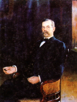
Johan Oskar Backlund was a Swedish-Russian astronomer. His name is sometimes given as Jöns Oskar Backlund, however even contemporary Swedish sources give "Johan". In Russia, where he spent his entire career, he is known as Oskar Andreevich Baklund. Russian sources sometimes give his dates of birth and death as 16 April 1846 and 16 August 1916, since Russia still used the Julian calendar at the time.

Barentsøya, anglicized as Barents Island, is an island in the Svalbard archipelago of Norway, lying between Edgeøya and Spitsbergen. Barents Island has no permanent human inhabitants. Named for the Dutch explorer Willem Barents, it is a part of Søraust-Svalbard Nature Reserve.

Svalbard has a population of approximately 2,395 people as of 2011. Approximately 70% of the people are Norwegians; the remaining 30% are Russian and Ukrainian. The official language of Svalbard is Norwegian. Russian is used in the Russian settlements.

Kongsøya is an island in Svalbard, Norway. It is the largest of the islands in King Charles Land. Its area is 191 square kilometres (74 sq mi). The other main island in the chain is Svenskøya.

Svenskøya is an island in Svalbard. It is the second largest island of Kong Karls Land with an area of 137 km².

Oscar II Land is the land area between Isfjorden and Kongsfjorden on Spitsbergen, Svalbard. The 30 km (19 mi) long glacier Sveabreen divides Oscar II Land from James I Land.
Lovénberget is a mountain in Ny-Friesland at Spitsbergen, Svalbard. It is located on Lomfjordhalvøya. Lovénberget is among the largest bird cliffs of Svalbard, the steep cliffs with heights of more than 400 meters facing east towards Hinlopen Strait. It is named after Swedish zoologist Sven Ludvig Lovén.
Retziusfjellet is a mountain on Kongsøya in Kong Karls Land, Svalbard. It is named after Swedish physician Gustaf Retzius. The mountain reaches a height of 320 meters, and is the highest point of Kongsøya. It is located south of Hårfagrehaugen, and northwest of Tordenskjoldberget.
Bergströmodden is a headland in Orvin Land at Nordaustlandet, Svalbard. It is located north of the mountain Boydfjellet, at the mouth of Finn Malmgren Fjord, east of Alpini Island. The headland is named after Swedish politician Axel Bergström.
Dunérfjellet is a mountain on Svenskøya in Kong Karls Land, Svalbard. It has a height of 230 m.a.s.l., and is located at the northern part of the island, separated from Mohnhøgda by the mountain pass Vindsalen. The mountain is named after Swedish astronomer Nils Christoffer Dunér. Dunérfjellet has a relatively flat plateau, with steep hills down to the lowlands of Svenskøya.

Keilhaufjellet is a mountain in Sørkapp Land at Spitsbergen, Svalbard. It has a height of 660 m.a.s.l. The mountain is named after Norwegian geologist Baltazar Mathias Keilhau. Keilhaufjellet was the southernmost triangulation point established during the Swedish-Russian Arc-of-Meridian Expedition.
Kapp Lovén is a headland in Gustav V Land at Nordaustlandet, Svalbard. It is located at the eastern side of Planciusbukta and west of Rijpfjorden, north of the mountain Båtkvelvet. The headland is named after Swedish zoologist Sven Ludvig Lovén.
Akademikarbreen is a glacier in Olav V Land at Spitsbergen, Svalbard. It covers an area of about 500 square kilometers and is located east of Backlundtoppen and Svanbergfjellet. The glacier extends from Billefjorden to the eastern coast, and borders to Lomonosovfonna, Negribreen and Kvitbreen. It is named after two members of Russian Academy of Science.
Svanbergfjellet is a mountain in Olav V Land at Spitsbergen, Svalbard. It has a height of 1,024 m.a.s.l. and is located east of Billefjorden and west of Akademikarbreen. The mountain is named after Swedish astronomer Jöns Svanberg. A point on the mountain was used as a trigonometric point during the Swedish-Russian Arc-of-Meridian Expedition.

Heclahamna is a natural harbour in Ny-Friesland at Spitsbergen, Svalbard. It is located south of Crozierpynten, at the eastern side of Sorgfjorden. The harbour is named after the British naval vessel Hecla from Parry's 1827 expedition. Swedish members of the Swedish-Russian Arc-of-Meridian Expedition built a land station at this site, and overwintered there from 1899 to 1900.
Törnbohmfjella is a mountain range in Nathorst Land at Spitsbergen, Svalbard. The range is named after the Swedish geologist Alfred Elis Törnebohm. It covers an area about nine kilometers long and six kilometers wide, bordering on Van Keulenfjorden, Davisdalen, Martinbreen, Richterbreen and Richterdalen. Its highest mountain peak is Såta, and it also comprises Pallfjellet, Kolthoffberget, Ekholmfjellet and Venetzhumpen. The glaciers of Charpentierbreen and Venetzbreen are located within the mountain range of Törnbohmfjella.

Arrheniusfjellet is a mountain in Torell Land at Spitsbergen, Svalbard. It is named after Swedish physicist Svante Arrhenius. The mountain has a height of 883 m.a.s.l. and is located at the head of Van Keulenfjorden. The glacier of Vindbreen separates Arrheniusfjellet from Vindfjellet at the southern side. The large glacier of Liestølbreen is situated between Arrheniusfjellet and Wijkberget, and Nathorstbreen is located southwest of the mountain.