
Holyrood Park is a royal park in central Edinburgh, Scotland about 1 mile to the east of Edinburgh Castle. It is open to the public. It has an array of hills, lochs, glens, ridges, basalt cliffs, and patches of gorse, providing a wild piece of highland landscape within its 650-acre (260 ha) area. The park is associated with the Palace of Holyroodhouse and was formerly a royal hunting estate. The park was created in 1541 when James V had the ground "circulit about Arthurs Sett, Salisborie and Duddingston craggis" enclosed by a stone wall.
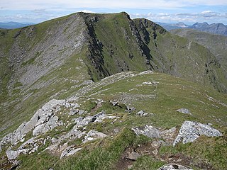
Sgùrr Choinnich is a mountain with a height of 999 metres (3,278 ft) in the Northwest Highlands of Scotland. Classed as a Munro, it is in the Achnashellach Forest area between Glen Carron and Loch Monar. It has mostly steep, grassy slopes, with a narrow summit ridge that runs east–west. There are crags on the northern side of this ridge, looking down into the corrie of Coire Choinnich.
An Sgùrr is a hill in Scotland, occupying the broad peninsula between Loch Carron and Loch Kishorn. It has the appearance of a rough knoll, with small crags ringing the summit, particularly on the western side.
Ben Hope is a mountain in northern Scotland. It is the most northerly Munro, standing alone in the Flow Country south-east of Loch Hope in Sutherland. The mountain is a roughly triangular wedge, with a great crag on the west, with two lower shoulders to the south and northeast. Alpine flowers are abundant in season, although the ground is very rocky.

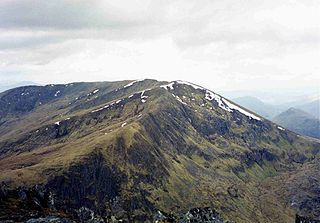
Beinn Narnain is a mountain in the southern Highlands of Scotland, near Arrochar. It forms part of a group of hills known (unofficially) as the Arrochar Alps, and is a Munro. The name Beinn Narnain means "hill of notches", and describes the mountain's notched profile.

Sgorr Ruadh is a mountain between Strath Carron and Glen Torridon in Wester Ross in the Northwest Highlands of Scotland. It is located in Coire Lair near Achnashellach along with two other mountains, Beinn Liath Mhòr and Fuar Tholl, and is often climbed together with one or both of these other mountains.

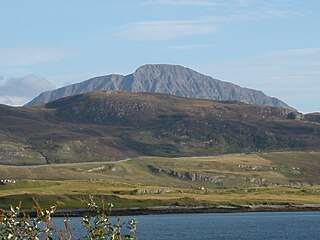
Slioch is a mountain in the Scottish Highlands situated in Wester Ross, eight kilometres north of the village of Kinlochewe. Slioch reaches an elevation of 981 metres and towers above the southeastern end of Loch Maree to give one of the best known and most photographed sights in the Highlands. VisitScotland, the Scottish national tourist agency, has used video footage of Slioch in its television advertisements.

Beinn Damh is a Scottish mountain situated in the wild mountainous area between Upper Loch Torridon and Glen Carron, 25 kilometres north northeast of Kyle of Lochalsh. Beinn Damh is classed as a Corbett reaching a height of 903 metres (2,962 feet) failing to qualify as a Munro by eleven metres, despite this it is a fine mountain with a four-kilometre-long undulating summit ridge with three tops, it has steep slopes and crags with its eastern face being especially dramatic with huge buttresses and cliffs. The mountain has the conspicuous “Stirrup Mark” just to the south west of the summit, this is a semi circular area of white quartzite surrounded by grey rock which stands out when the mountain is viewed from the south west. The mountain's translated name of “Hill of the Stag” is apt because it stands in the middle of the Ben Damh deer estate.
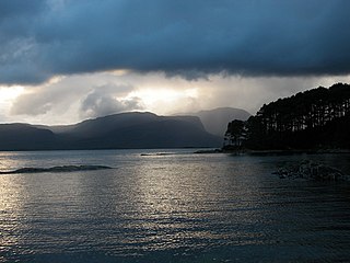
Loch Carron is a sea loch on the west coast of Ross and Cromarty in the Scottish Highlands, which separates the Lochalsh peninsula from the Applecross peninsula, and from the Stromeferry headland east of Loch Kishorn. It is the point at which the River Carron enters the North Atlantic Ocean.

Mòruisg is a Scottish mountain situated in the Glencarron and Glenuig Forest, 10 kilometres south west of the village of Achnasheen in the Highland council area.

Gairich, sometimes Sgurr Gairoch, is a mountain in Lochaber in the Northwest Highlands of Scotland. It is on the southern side of Loch Quoich, with Glen Garry to the east and Glen Kingie to the south, 25 kilometres north-northwest of Fort William.

Sgùrr nan Each is a Scottish mountain situated in the group of hills known as the Fannichs. It is 27 kilometres (17 mi) south of Ullapool in the Ross and Cromarty district of the Highland council area.
An Riabhachan is a Scottish mountain in the Skye and Lochalsh district of the Highland council area. It is situated 35 kilometres east of Kyle of Lochalsh standing in an isolated position at the western end of Loch Mullardoch, ten kilometres from any public road.

Beinn Sgritheall or Beinn an Sgrithill, also anglicized Ben Sgriol, is the highest mountain on the Glenelg peninsula in the Northwest Highlands of Scotland. It is a Munro with a height of 974 metres (3,196 ft). The main approach is via Arnisdale on the shores of Loch Hourn or via Gleann Beag to the north, with its well-known brochs. The view from the summit was described by Sir Hugh Munro, a founder member of the Scottish Mountaineering Club, as "perhaps the most beautiful I have seen in Scotland".

Beinn a' Chuallaich is a Scottish hill, four kilometres northeast of the village of Kinloch Rannoch in the Perth and Kinross council area. It is part of the high ground between Strath Tummel and Glen Errochty.

An Ruadh-stac is a Scottish mountain situated in the Wester Ross region of the Highland council area. It is located 26 km north east of Kyle of Lochalsh.

Beinn a' Chaisteil is a mountain in the southern Highlands of Scotland, it is located 6.25 km north of Tyndrum on the border of Perth and Kinross and Argyll and Bute council areas. This hill is not to be confused with another Beinn a' Chaisteil, above Loch Vaich in Highland Council area.

Meall na h-Eilde is a Scottish hill situated in the high ground between the Great Glen and Glen Garry, 23 km north of Fort William in the Highland Council Area.

The Moffat Hills are a range of hills in the Southern Uplands of Scotland. They form a roughly triangular shape with a west facing side, a north facing side, and a south-east facing side. It is 17 kilometres from east to west across this triangle and some 16 kilometres north to south. The highest point is White Coomb at 821 m (2694 ft). The town of Moffat lies just south of the Moffat hills and along with Tweedsmuir, at the northern extremity, is the only centre of population around these hills. In some older maps, the northern part of the Moffat Hills is called the Tweedsmuir Hills, but can also be known by the title Manor Hills.

Lurg Mhòr is a remote 986-metre (3,235 ft) mountain, a Munro, in the Northwest Highlands of Scotland at the high point of an east–west range of hills comprising Meall Mor, Lurg Mhòr and Bidein a' Choire Sheasgaich.

