
Oxfordshire is a ceremonial county in South East England. The county is bordered by Northamptonshire and Warwickshire to the north, Buckinghamshire to the east, Berkshire to the south, and Wiltshire and Gloucestershire to the west. The city of Oxford is the largest settlement and county town.

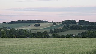
The Uffington White Horse is a prehistoric hill figure, 110 m (360 ft) long, formed from deep trenches filled with crushed white chalk. The figure is situated on the upper slopes of Whitehorse Hill in the English civil parish of Uffington in Oxfordshire, some 16 km (10 mi) east of Swindon, 8 km (5.0 mi) south of the town of Faringdon and a similar distance west of the town of Wantage; or 2.5 km (1.6 mi) south of Uffington. The hill forms a part of the scarp of the Berkshire Downs and overlooks the Vale of White Horse to the north. The best views of the figure are obtained from the air, or from directly across the Vale, particularly around the villages of Great Coxwell, Longcot, and Fernham.
The Vale of White Horse is a local government district of Oxfordshire in England. It was historically part of Berkshire. The area is commonly referred to as the 'Vale of the White Horse'. It is crossed by the Ridgeway National Trail in its far south, across the North Wessex Downs AONB at the junction of four counties. The northern boundary is defined by the River Thames. The name refers to Uffington White Horse, a prehistoric hill figure.

Faringdon is a historic market town in the Vale of White Horse, Oxfordshire, England, 18 miles (29 km) south-west of Oxford, 10 miles (16 km) north-west of Wantage and 12 miles (19 km) east-north-east of Swindon. It extends to the River Thames in the north; the highest ground is on the Ridgeway in the south. Faringdon was Berkshire's westernmost town until the 1974 boundary changes transferred its administration to Oxfordshire. The civil parish is formally known as Great Faringdon, to distinguish it from Little Faringdon in West Oxfordshire. The 2011 Census gave a population of 7,121; it was estimated at 7,992 in 2019. On 1 February 2004, Faringdon became the first place in south-east England to be awarded Fairtrade Town status.

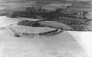
Badbury Rings is an Iron Age hill fort and Scheduled Monument in east Dorset, England. It was in the territory of the Durotriges. In the Roman era a temple was located immediately west of the fort, and there was a Romano-British town known as Vindocladia a short distance to the south-west.

Hod Hill is a large hill fort in the Blackmore Vale, 3 miles (5 km) north-west of Blandford Forum, Dorset, England. The fort sits on a 143 m (469 ft) chalk hill of the same name that lies between the adjacent Dorset Downs and Cranborne Chase. The hill fort at Hambledon Hill is just to the north. The name probably comes from Old English "hod", meaning a shelter, though "hod" could also mean "hood", referring to the shape of the hill.

Wantage is a constituency in Oxfordshire represented in the House of Commons of the Parliament of the United Kingdom by Conservative MP David Johnston.

Blue Bell Hill is a chalk hill between Maidstone and Rochester in the English county of Kent. It overlooks the River Medway and is part of the North Downs. Settlements on the hill include the Walderslade suburb of Chatham and the villages of Blue Bell Hill and Kit's Coty. During the eighteenth and nineteenth centuries much of the hill was quarried for chalk.

Shilton is a village and civil parish about 1+1⁄2 miles (2.4 km) northwest of Carterton, Oxfordshire. The 2011 Census recorded the parish's population as 626.
The A420 is a road between Bristol and Oxford in England. Between Swindon and Oxford it is a primary route.
Wittenham Clumps are a pair of wooded chalk hills in the Thames Valley, in the civil parish of Little Wittenham, in the historic county of Berkshire, although since 1974 administered as part of South Oxfordshire district.

Great Coxwell Barn is a Medieval tithe barn at Great Coxwell, Oxfordshire, England. It is on the northern edge of the village of Great Coxwell, which is about 9 miles (14 km) northeast of Swindon in neighbouring Wiltshire.
Founded in 1967, Earth Trust is an environmental charity which was originally known as the Northmoor Trust for Countryside Conservation. Earth Trust was initially established by the British engineer Sir Martin Wood to promote environmental conservation through land management, education, and land science. It is a registered charity under English law.

Chain Hill is one of the hills of the Berkshire Downs, located in the civil parish of Wantage in the English county of Oxfordshire. In 1974 it was transferred from Berkshire. It is designated part of the North Wessex Downs Area of Outstanding Natural Beauty by the Countryside Agency and forms part of the Vale of White Horse.

Great Coxwell is a village and civil parish 2 miles (3 km) southwest of Faringdon in the Vale of White Horse, England. It was in Berkshire until the 1974 boundary changes transferred it to Oxfordshire. The 2021 Census recorded the parish's population as 295 in 124 households.

Little Coxwell is a village and civil parish in South East England, about 1.5 miles (2.4 km) south of Faringdon and 0.8 miles (1.3 km) east of Great Coxwell. Little Coxwell was part of Berkshire until the 1974 local government boundary changes transferred the Vale of White Horse to Oxfordshire. Cistercian monks of Beaulieu Abbey built the Church of England parish church of Saint Mary in the 12th century as a chapel of ease. Little Coxwell was a dependent chapelry of the ecclesiastical parish of Great Faringdon. In 1866 the civil parish was established. The village has a public house, the Eagle Tavern. The Hurlingham Polo Association, the governing body for polo in the UK, Ireland, and many other countries, has its office at Manor Farm, Little Coxwell.

Eaton Hastings is a village and civil parish beside the River Thames about two-and-a-half miles (4 km) north-west of Faringdon. It was in Berkshire until the 1974 boundary changes transferred it to Oxfordshire. Eaton Hastings was once larger than it is today, when it can be seen as an all-but-deserted medieval village. The 2001 Census gave the parish population as 81.

The Corallian Group or Corallian Limestone is a geologic group in England. It is predominantly a coralliferous sedimentary rock, laid down in the Oxfordian stage of the Jurassic. It is a hard variety of "coral rag". Building stones from this geological structure tend to be irregular in shape. It is often found close to seams of Portland Limestone. It is a younger limestone than its near-neighbour, the Oolitic, as found in the Cotswolds, in Gloucestershire. It is laterally equivalent to and interfingers with units of the Ancholme Group.
Matthew David Barber is a British politician. He is currently Thames Valley Police and Crime Commissioner. He previously served as Leader of the Council on Vale of White Horse District Council and Deputy Police and Crime Commissioner for the Thames Valley Police.
