
Lindisfarne, also called Holy Island, is a tidal island off the northeast coast of England, which constitutes the civil parish of Holy Island in Northumberland. Holy Island has a recorded history from the 6th century AD; it was an important centre of Celtic Christianity under Saints Aidan of Lindisfarne, Cuthbert, Eadfrith of Lindisfarne and Eadberht of Lindisfarne. After the Viking invasions and the Norman conquest of England, a priory was re-established. A small castle was built on the island in 1550.
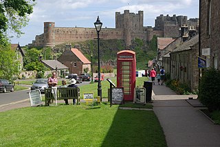
Bamburgh is a village and civil parish on the coast of Northumberland, England. It had a population of 454 in 2001, decreasing to 414 at the 2011 census.
Worksop is a market town in the Bassetlaw District in Nottinghamshire, England. It is located 19 miles (31 km) east-south-east of Sheffield, close to Nottinghamshire's borders with South Yorkshire and Derbyshire, on the River Ryton and not far from the northern edge of Sherwood Forest.
Aston Clinton is a historic village and civil parish in the Vale of Aylesbury in Buckinghamshire, England. The village lies at the foot of the Chiltern Hills, between the Wendover and Aylesbury arms of the Grand Union Canal. Surrounding towns include Wendover to the south, Aylesbury to the west, and Tring to the east - across the nearby county border with Hertfordshire.

Anglo-Saxon architecture was a period in the history of architecture in England, and parts of Wales, from the mid-5th century until the Norman Conquest of 1066. Anglo-Saxon secular buildings in Britain were generally simple, constructed mainly using timber with thatch for roofing. No universally accepted example survives above ground.

Wing, known in antiquated times as Wyng, is a village and civil parish in east Buckinghamshire, England. The village is on the main A418 road between Aylesbury and Leighton Buzzard. It is about 8 miles (13 km) north-east of Aylesbury, 3 miles (5 km) west of Leighton Buzzard, and 12 miles (19 km) south of Milton Keynes.

Baddesley Clinton is a moated manor house, about 8 miles (13 km) north-west of the town of Warwick, in the village of Baddesley Clinton, Warwickshire, England. The house probably originated in the 13th century, when large areas of the Forest of Arden were cleared for farmland. The site is a Scheduled Ancient Monument and the house is a Grade I listed building. The house, park and gardens are owned by the National Trust and open to the public; they lie in a civil parish of the same name.

The Metropolitan Borough of Solihull is a metropolitan borough in West Midlands county, England. It is named after its largest town, Solihull, from which Solihull Metropolitan Borough Council is based. It is sometimes locally nicknamed "Solihullshire". For Eurostat purposes it is a NUTS 3 region and is one of seven boroughs or unitary districts that comprise the "West Midlands" NUTS 2 region. Much of the large residential population in the north of the borough centres on the communities of Castle Bromwich, Chelmsley Wood, Fordbridge, Kingshurst, Marston Green and Smith's Wood. In the south are the towns of Solihull and Shirley, and the large villages of Knowle, Dorridge, Meriden and Balsall Common.

Arden is an area located mainly in Warwickshire, England, with parts in Staffordshire and Worcestershire, and is traditionally regarded as extending from the River Avon to the River Tame. It was once heavily wooded, giving rise to the name 'Forest of Arden'.

This is about the history of the county Warwickshire situated in the English Midlands. Historically, bounded to the north-west by Staffordshire, by Leicestershire to the north-east, Northamptonshire to the east, Worcestershire to the west, Oxfordshire to the south and Gloucestershire to the south-west. Areas historically part of Warwickshire include Coventry, Solihull, Sutton Coldfield and a small area of central Birmingham including Aston and Edgbaston. These became part of the metropolitan county of West Midlands following local government re-organisation in 1974 after the passage of the Local Government Act 1972.
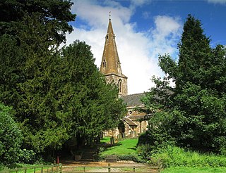
Lapworth is a village and civil parish in Warwickshire, England, which had a population of 2,100 according to the 2001 census; this had fallen to 1,828 at the 2011 Census. It lies six miles (10 km) south of Solihull and ten miles (16 km) northwest of Warwick, and incorporates the hamlet of Kingswood. Lapworth boasts an historic church, the Church of St Mary the Virgin, a chapel. Two National Trust sites are nearby: Baddesley Clinton, a medieval moated manor house and garden located in the village of Baddesley Clinton; and Packwood House, a Tudor manor house and yew garden with over 100 trees in Packwood.

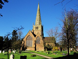
Hockley Heath is a large village and civil parish in the Arden area mostly within the Metropolitan Borough of Solihull, West Midlands, England, incorporating the hamlet of Nuthurst, with a history dating back to the year 705 AD as a wood owned by Worcester Cathedral. The parish, known as Nuthurst cum Hockley Heath, is to the south of the West Midlands conurbation, 12 miles (19 km) southeast of Birmingham 5.5 miles (8.9 km) from Solihull town centre and 12.5 miles (20.1 km) north of Stratford-upon-Avon. The village forms part of the border with Warwickshire and the District of Stratford-on-Avon to the south, with some parts of the village on either side of the border. According to the 2001 census, the parish had a population of 6,771, being measured at the 2011 Census as 2,038.

North Baddesley is a large village and civil parish in Hampshire, England. It is situated 3 mi (5 km) east of the town of Romsey and 6 mi (10 km) north of Southampton. It occupies an area of approximately 9.15 km2 (3.53 sq mi), and is home to a population of just over 10,000 people, reducing to 7,000 at the 2011 Census. It is located in the Test Valley; a river famous for trout fishing. North Baddesley is one of the largest villages in the South of England, larger than many market towns.

Chirbury is a village in west Shropshire, England. It is situated in the Vale of Montgomery, close to the Wales–England border, which is to its north, west and south. The A490 and B4386 routes cross at Chirbury.
Gumley is a village and civil parish in the Harborough district, in the county of Leicestershire, England, United Kingdom. The closest town is Market Harborough. The population of the civil parish at the 2011 census was 209.
Solihull is a large market town that is the administrative centre and seat of the Metropolitan Borough of Solihull in the south of the West Midlands County, England. The town had a population of 123,187 at the 2011 Census. Historically in Warwickshire, Solihull is situated on the River Blythe in the Forest of Arden area. It is the largest town in the Metropolitan Borough of Solihull which has a population of 214,909.
Edenham is a village and civil parish in the South Kesteven district of Lincolnshire, England. It is approximately 3 miles (5 km) north-west of Bourne, and on the A151 road. While the civil parish is called 'Edenham', the parish council is called Edenham, Grimsthorpe, Elsthorpe & Scottlethorpe Parish Council. The population of the civil parish at the 2011 census was 291.

Coughton is a small village located between Studley 2.4 miles (4 km) to the North and Alcester, 2 miles (3 km) to the South, in the county of Warwickshire, England. The village lies 19.3 miles (31 km) from Birmingham on the Birmingham–Alcester A435 road, which here follows the line of the Roman Icknield Street.

Teffont Evias is a small village and former civil parish in the Nadder valley in the south of Wiltshire, England. Edric Holmes described the village as "most delightfully situated", and Maurice Hewlett included Teffont in his list of the half dozen most beautiful villages in England. The present buildings are mostly of local stone, and several are thatched.

Oulton is a civil parish on the western edge of the town of Lowestoft in the north of the English county of Suffolk. It is in the East Suffolk district. The eastern part of the parish forms part of the suburbs of Lowestoft, whilst the western section extends into The Broads national park, reaching the River Waveney and Oulton Dyke.

