
Maple Forest Township is a civil township of Crawford County in the U.S. state of Michigan. The population was 653 at the 2010 census.

Port William is a village in Clinton County, Ohio, United States. The population was 229 at the 2020 census.

The Cannon Valley Trail is a paved rail trail that follows the Cannon River in southeast Minnesota. The trail follows an abandoned Chicago Great Western Railway corridor for 20 miles (32 km) between Cannon Falls, Minnesota and Red Wing, Minnesota. In the spring, summer, and fall months, the trail is open to hiking, biking, and inline skating. In the winter months, the trail is groomed for cross-country skiing.

Yawan is one of the 28 districts of Badakhshan province in eastern Afghanistan. It was created in 2005 from part of the Ragh District and is home to approximately 36,037 residents.
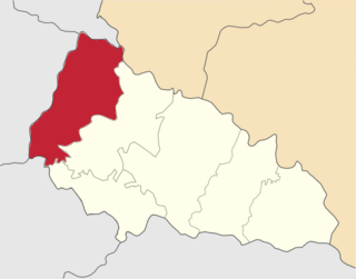
Uzhhorod Raion is one of the raions (districts) of Zakarpattia Oblast in western Ukraine. Its administrative center is located in the city of Uzhhorod. Over 30% of population in the raion speak the Hungarian language according to the latest census. Population: 255,000.

Port Kent is a hamlet within the town of Chesterfield, Essex County, New York, United States, on the western shore of Lake Champlain. Its population was last recorded as 217 (141 households). Its ZIP code is 12975.

Old Saint Louis is an unincorporated community in Haw Creek Township, Bartholomew County, in the U.S. state of Indiana.
Poniatówek is a village in the administrative district of Gmina Goszczanów, within Sieradz County, Łódź Voivodeship, in central Poland. It lies approximately 3 kilometres (2 mi) north-east of Goszczanów, 28 km (17 mi) north-west of Sieradz, and 65 km (40 mi) west of the regional capital Łódź.
Duraczów is a village in the administrative district of Gmina Stąporków, within Końskie County, Świętokrzyskie Voivodeship, in south-central Poland. It lies approximately 6 kilometres (4 mi) south of Stąporków, 14 km (9 mi) south-east of Końskie, and 26 km (16 mi) north of the regional capital Kielce.
Komorów is a village in the administrative district of Gmina Stąporków, within Końskie County, Świętokrzyskie Voivodeship, in south-central Poland. It lies approximately 9 kilometres (6 mi) south of Stąporków, 17 km (11 mi) south-east of Końskie, and 23 km (14 mi) north of the regional capital Kielce.
Romanówka is a village in the administrative district of Gmina Dwikozy, within Sandomierz County, Świętokrzyskie Voivodeship, in south-central Poland. It lies approximately 7 kilometres (4 mi) north-west of Dwikozy, 12 km (7 mi) north of Sandomierz, and 80 km (50 mi) east of the regional capital Kielce.
Bąsewice is a village in the administrative district of Gmina Nowa Wieś Lęborska, within Lębork County, Pomeranian Voivodeship, in northern Poland. It lies approximately 13 kilometres (8 mi) north of Nowa Wieś Lęborska, 14 km (9 mi) north of Lębork, and 65 km (40 mi) north-west of the regional capital Gdańsk.
Rychliki is a village in Elbląg County, Warmian-Masurian Voivodeship, in northern Poland. It is the seat of the gmina called Gmina Rychliki. It lies approximately 15 kilometres (9 mi) south-east of Elbląg and 68 km (42 mi) west of the regional capital Olsztyn.
Lubstyn is a village in the administrative district of Gmina Lubawa, within Iława County, Warmian-Masurian Voivodeship, in northern Poland.
Iłowo is a settlement in the administrative district of Gmina Myślibórz, within Myślibórz County, West Pomeranian Voivodeship, in north-western Poland.
Belaiba is a town and commune in M'Sila Province, Algeria.
Gornji Krupac is a village in the municipality of Aleksinac, Serbia. According to the 2002 census, the village has a population of 510 people.
Colville Air Force Station is a closed United States Air Force General Surveillance Radar station. It is located 14.7 miles (23.7 km) east-northeast of Colville, Washington. It was closed in 1961.
Malo Orašje is a village in the municipality of Smederevo, Serbia. According to the 2002 census, the village has a population of 1139 people.

Khachatur Abovyan Park, is a park located in the Kentron district of Yerevan, Armenia, at the north of Abovyan Street. It forms the starting point of the Abovyan Street. The Yerevan State Medical University is located at the southern edge of the park.

