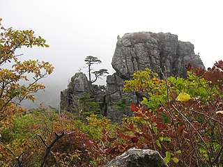
Paektu Mountain, also known as Baekdu Mountain and in China as Changbai Mountain, is an active stratovolcano on the Chinese–North Korean border. At 2,744 m (9,003 ft), it is the highest mountain of the Baekdudaegan and Changbai ranges. Koreans assign a mythical quality to the volcano and its caldera lake, considering it to be their country's spiritual home. It is the highest mountain in Korea and Northeast China.

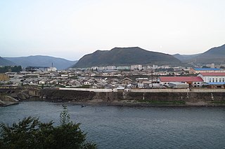
Hyesan is a city in the northern part of Ryanggang province of North Korea. It is a hub of river transportation as well as a product distribution centre. It is also the administrative centre of Ryanggang Province. As of 2008, the population of the city is 192,680.

Heaven Lake is a crater lake on the border between China and North Korea. It lies within a caldera atop the volcanic Paektu Mountain, a part of the Baekdudaegan and Changbai mountain ranges. It is located partly in Ryanggang Province, North Korea, at 42.006°N 128.057°E, and partly in Jilin Province, northeastern China. Heaven Lake has been recognized as the highest volcanic lake in the world by the Shanghai Office of the Guinness Book of Records.

Jirisan is a mountain located in the southern region of South Korea. It is the second-tallest mountain in South Korea after Jeju Island's Hallasan, and the tallest mountain in mainland South Korea.

Mount Kumgang or the Kumgang Mountains are a mountain/mountain range, with a 1,638-metre-high (5,374 ft) Birobong peak, in Kangwon-do, North Korea. It is about 50 kilometres (31 mi) from the South Korean city of Sokcho in Gangwon-do. It is one of the best-known mountains in North Korea. It is located on the east coast of the country, in Mount Kumgang Tourist Region, formerly part of Kangwŏn Province. Mount Kumgang is part of the Taebaek mountain range which runs along the east of the Korean Peninsula.
The 1909 Gando Convention was a treaty signed between Imperial Japan and Qing China in which Japan recognized China's claims to Jiandao, called Gando in Korean, and Mount Paektu, and in return Japan received railroad concessions in Northeast China ("Manchuria"). After the Surrender of Japan, Gando Convention was de jure nullified. While China took control of Manchuria and the northwestern half of Mt. Paektu, the Korean government north of the 38th Parallel took control of the southeastern half of Mt. Paektu in addition to taking control of the Korean Peninsula north of the 38th Parallel.

Mount San Antonio, commonly referred to as Mount Baldy or Old Baldy, is a 10,066 feet (3,068 m) summit in the San Gabriel Mountains in Los Angeles County, California. Lying within the San Gabriel Mountains National Monument and Angeles National Forest, it is the high point of the range, the county, and the Los Angeles metropolitan area. Mount San Antonio's sometimes snow-capped peaks are visible on clear days and dominate the view of the Los Angeles Basin skyline. The summit and a subsidiary peak to the west form a double-peaked high point of a steep-sided east-west ridge. The summit is accessible via a number of connecting ridges along hiking trails from the north, east, south and southwest.

Korea comprises the Korean Peninsula and 3,960 nearby islands. The peninsula is located in Northeast Asia, between China and Japan. To the northwest, the Amnok River separates Korea from China and to the northeast, the Duman River separates Korea from China and Russia. The Yellow Sea lies to the west, the East China Sea and Korea Strait to the south, and the [The East Sea]] to the east. Notable islands include Jeju Island (Jejudo), Ulleung Island (Ulleungdo), and the Liancourt Rocks.

The National Emblem of the Democratic People's Republic of Korea is the coat of arms of North Korea, officially known as the Democratic People's Republic of Korea. The current version adopted in 1993 is based on a design that was used since the foundation of the republic in 1948. Two previous versions were briefly in use in the late 1940s. Prominent features on the emblem are a red star, a hydroelectric plant and Mount Paektu. The design bears similarities to the emblem of the Soviet Union and other emblems of the socialist heraldic style.

Jogyesa is the chief temple of the Jogye Order of Korean Buddhism. The building dates back to the late 14th century and became the order's chief temple in 1936. It thus plays a leading role in the current state of Seon Buddhism in South Korea. The temple was first established in 1395, at the dawn of the Joseon Dynasty; the modern temple was founded in 1910 and initially called "Gakhwangsa". The name was changed to "Taegosa" during the period of Japanese rule, and then to the present name in 1954.

Taebaeksan, also known as Mount Taebaeksan or Mount Taebaek, is a South Korean mountain with several important peaks of the Taebaek mountain range, or the Taebaek Jeongmaek Range. It is an important mountain in the Baekdu-daegan Mountain-system Baekdudaegan, the point where it turns west after running along Korea's east coast for a long distance. Its territory stretches from the city of Taebaek in Yeongwol-gun County, Gangwon-do Province to Bonghwa-gun County, Gyeongsangbuk-do Province, and it was designated South Korea's 22nd national park on 22 August 2016. It has an elevation of 1,566.7 m (5,140 ft).

Upon its liberation in 1945 and subsequent foundation in 1948, North Korea adopted national symbols distinct from the national symbols of South Korea. The traditional flag of Korea, the Taegukgi, and the symbol Taeguk, were swapped for communist symbols.

Banyasa is a Buddhist temple of the Jogye Order in Chungcheong, South Korea.
"We Will Go to Mount Paektu" is a 2015 North Korean light music song in praise of the country's leader, Kim Jong-un.
The Five Mountains of Korea are five renowned mountains in Korean culture:

Ullim Falls is a waterfall located outside of Wŏnsan, North Korea.

Ashfall, also known as: Mount Paektu, is a 2019 South Korean disaster film directed by Lee Hae-jun and Kim Byung-seo, starring Lee Byung-hun, Ha Jung-woo, Ma Dong-seok, Jeon Hye-jin and Bae Suzy. The film was released in December 2019 in South Korea.

Jirisan is a South Korean television series starring Jun Ji-hyun and Ju Ji-hoon. It is named after the eponymous mountain in South Korea and has been promoted as "tvN's 15th Anniversary Special Drama". It premiered on tvN on October 23 to December 12, 2021 and aired every Saturday and Sunday at 21:00 (KST). The series is available on iQIYI worldwide for streaming.

David Alan Mason is an American academic usually based in South Korea. He has been a professor of cultural tourism at Sejong University in Seoul since 2014. He has authored about 10 prominent books on Korean culture, spirituality, travel and mountains, and serves as a scholar, author, public speaker and tour guide. He remains a well-known authority on Korean spiritual traditions of all kinds, especially about his core topic the Sansin deity and their shrines found throughout Korea called Sansin-gak, integral parts of Korean Buddhist temples, Korean Shamanism and village life. He is also an expert on the Baekdu-daegan mountain range and Korea's national parks, having visited all 20 as of 2011.

Mount Emma is a 13,581-foot-elevation mountain summit located in San Miguel County of Colorado, United States. It is situated three miles north of the community of Telluride, on the south side of Yankee Boy Basin, in the Uncompahgre National Forest. It is part of the Sneffels Range which is a subset of the San Juan Mountains, which in turn is part of the Rocky Mountains. Mount Emma is situated west of the Continental Divide, two miles south of Mount Sneffels, and 0.8 mile south of Gilpin Peak, the nearest higher neighbor. Emma ranks as the 197th-highest peak in Colorado, and the 10th-highest in the Sneffels Range. Topographic relief is significant as the south aspect rises 4,830 feet (1,472 meters) above Telluride in approximately three miles. An ascent of Mt. Emma is a difficult climb with 2,180 feet of elevation gain covering three miles from Yankee Boy Basin, or 4,836 feet of elevation gain from Telluride. This mountain's name was officially adopted by the U.S. Board on Geographic Names.


