Related Research Articles
Achasanseong Fortress is an earthen mountain fortress dating from the Korean Three Kingdoms period. Originally built by Baekje, it was occupied in turn by each of the Three Kingdoms. It stands on Achasan Mountain, in Gwangjin-gu, Seoul, South Korea, at an altitude of 200 meters above sea level. It has a perimeter of roughly 1 kilometer and an area of about 3375 m².

Gyeryongsan, a 845 m (2,772 ft) mountain in South Chungcheong Province, South Korea. It lies at the meeting of the boundaries of several cities: Gongju, Gyeryong, Nonsan, and Daejeon. It has been traditionally regarded as a sacred mountain, with the most qi of any in South Korea. The name Gyeryongsan means chicken dragon mountain. Portions of the mountain are included in a South Korean military reserve. Other portions are part of Gyeryongsan National Park. In the mountain, there are famous Buddhist temples such as Donghaksa, Gapsa and Sinwonsa, the latter two both being over a thousand years old. In addition the highest peak, Cheonhwangbong, there are seven other peaks with an elevation exceeding 500m
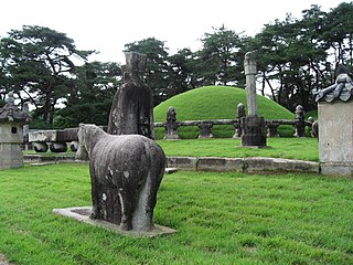
The Tombs of the Joseon dynasty refers to the 40 tombs of members of the House of Yi, which ruled Korea between 1392–1910. These tombs are scattered over 18 locations across the Korean Peninsula. They were built to honor and respect the ancestors and their achievements and assert their royal authority. The tombs have been registered as an UNESCO World Heritage Site since 2009. Two other Joseon tombs, located in Kaesong, North Korea, were proposed but not submitted.

Dongmyo Station is a station on the Seoul Subway Line 1 and Line 6. It is named after a nearby shrine, built during the Joseon dynasty to honor Guan Yu, arguably the most famous Chinese military general from the Three Kingdoms era.
Sangbongsan is a mountain in Incheon, South Korea. It sits on the island of Seongmodo in the county of Ganghwa. Sangbongsan has an elevation of 316 m (1,037 ft).
Bulgisan (Korean: 불기산) is a mountain in Gyeonggi Province, South Korea. The mountain sits in Gapyeong County. Bulgisan has an elevation of 610 m (2,001 ft).
Cheongwusan (Korean: 청우산) is a mountain in Gyeonggi-do, South Korea. It can be found in the county of Gapyeong. Cheongwusan has an elevation of 619 m (2,031 ft).
Ungilsan is a mountain near the city of Namyangju, Gyeonggi Province in South Korea. It has an elevation of 610.2 m (2,002 ft).
Wangbangsan is a mountain in Gyeonggi Province, South Korea. It lies between the cities of Pocheon and Dongducheon. It has an elevation of 737 m (2,418 ft).

Yeoninsan is a mountain in the county of Gapyeong, Gyeonggi Province in South Korea. It has an elevation of 737 m (2,418 ft).
Bawisan is a mountain in the city of Chuncheon, Gangwon-do in South Korea. It has an elevation of 858 m (2,815 ft).
Daedeoksan is a mountain in the cities of Taebaek and Samcheok, Gangwon-do in South Korea. It has an elevation of 1,307 m (4,288 ft).
Maehwasan is a South Korean mountain between Hoengseong County and Wonju, Gangwon-do. It has an elevation of 1,085 m (3,560 ft).
Majeoksan is a mountain in the city of Chuncheon, Gangwon-do in South Korea. It has an elevation of 605.2 m (1,986 ft).
Palbongsan is a mountain in the county of Hongcheon, Gangwon-do in South Korea. It has an elevation of 302 m (991 ft).
Samaksan is a mountain in the city of Chuncheon, Gangwon-do in South Korea. It has an elevation of 654 m (2,146 ft).
Seonjaryeong is a mountain in the county of Pyeongchang and the city of Gangneung, Gangwon-do in South Korea. It has an elevation of 1,157 m (3,796 ft).
Yonghwasan is a mountain in the city of Chuncheon and the county of Hwacheon, Gangwon-do in South Korea. It has an elevation of 878.4 m (2,882 ft).
Bakdalsan is a mountain in the county of Goesan, North Chungcheong Province in South Korea. It has an elevation of 825 m (2,707 ft).
Boryeonsan is a mountain in the city of Chungju, North Chungcheong Province in South Korea. It has an elevation of 765 m (2,510 ft).
References
- Yu Jeong-yeol (2007). 한국의 산 여행 (Travel Guide to Korean Mountains). Seoul: 관동 상억연구회 (Kwandong). ISBN 978-89-958055-1-0.