
Erzgebirgsstadion is a multi-purpose stadium in Aue, Germany. It is currently used mostly for football matches and is the home stadium of FC Erzgebirge Aue. The stadium is able to hold 15,690 people and was built in 1950.
Gmina Kurzętnik is a rural gmina in Nowe Miasto County, Warmian-Masurian Voivodeship, in northern Poland. Its seat is the village of Kurzętnik, which lies approximately 2 kilometres (1 mi) south of Nowe Miasto Lubawskie and 75 km (47 mi) south-west of the regional capital Olsztyn.
The McConnell State Recreation Area is on the banks of the Merced River, about two miles northeast of Livingston. Fishing is popular for catfish, black bass and perch. There are picnic, camping and play areas.

Kończyce is a village in the administrative district of Gmina Nowe, within Świecie County, Kuyavian-Pomeranian Voivodeship, in north-central Poland. It lies approximately 2 kilometres (1 mi) south-west of Nowe, 31 km (19 mi) north-east of Świecie, and 68 km (42 mi) north of Toruń.
Siwe Bagno is a village in the administrative district of Gmina Cekcyn, within Tuchola County, Kuyavian-Pomeranian Voivodeship, in north-central Poland.
Kobyla Łąka is a village in the administrative district of Gmina Lubień Kujawski, within Włocławek County, Kuyavian-Pomeranian Voivodeship, in north-central Poland.
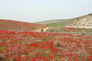
Hevel Lakhish is an area of south-central Israel. Part of the southern Shephelah, it is located between the Judean Mountains and the Mediterranean Sea and is named after the Biblical city of Lachish.
Budy is a village in the administrative district of Gmina Rajgród, within Grajewo County, Podlaskie Voivodeship, in north-eastern Poland. It lies approximately 4 kilometres (2 mi) south of Rajgród, 18 km (11 mi) east of Grajewo, and 72 km (45 mi) north-west of the regional capital Białystok.
Rybczyzna is a village in the administrative district of Gmina Rajgród, within Grajewo County, Podlaskie Voivodeship, in north-eastern Poland. It lies approximately 4 kilometres (2 mi) south of Rajgród, 18 km (11 mi) east of Grajewo, and 72 km (45 mi) north-west of the regional capital Białystok.
Bagno is a village in the administrative district of Gmina Śniadowo, within Łomża County, Podlaskie Voivodeship, in north-eastern Poland.
Bagno is a village in the administrative district of Gmina Jaświły, within Mońki County, Podlaskie Voivodeship, in north-eastern Poland. It lies approximately 2 kilometres (1 mi) south of Jaświły, 11 km (7 mi) north-east of Mońki, and 41 km (25 mi) north-west of the regional capital Białystok.
Budzisk-Bagno is a settlement in the administrative district of Gmina Janów, within Sokółka County, Podlaskie Voivodeship, in north-eastern Poland.
Sosnowe Bagno is a village in the administrative district of Gmina Janów, within Sokółka County, Podlaskie Voivodeship, in north-eastern Poland.

Həsənqoca is a village in the Khachmaz Rayon of Azerbaijan.
Salahlı Kəngərli is a village in the Agdam Rayon of Azerbaijan.
Gilwa is a village in the administrative district of Gmina Prabuty, within Kwidzyn County, Pomeranian Voivodeship, in northern Poland. It lies approximately 6 kilometres (4 mi) south-west of Prabuty, 15 km (9 mi) east of Kwidzyn, and 81 km (50 mi) south-east of the regional capital Gdańsk.

Kacze Bagno is a settlement in the administrative district of Gmina Kurzętnik, within Nowe Miasto County, Warmian-Masurian Voivodeship, in northern Poland.

Bagno is a village in the administrative district of Gmina Nowe Miasto Lubawskie, within Nowe Miasto County, Warmian-Masurian Voivodeship, in northern Poland. It lies approximately 12 kilometres (7 mi) north of Nowe Miasto Lubawskie and 71 km (44 mi) south-west of the regional capital Olsztyn.
Kiersztanowo is a village in the administrative district of Gmina Grunwald, within Ostróda County, Warmian-Masurian Voivodeship, in northern Poland. It lies approximately 19 kilometres (12 mi) south-east of Ostróda and 35 km (22 mi) south-west of the regional capital Olsztyn.
Sławsko is a village in the administrative district of Gmina Sławno, within Sławno County, West Pomeranian Voivodeship, in north-western Poland. It lies approximately 4 kilometres (2 mi) north-east of Sławno and 177 km (110 mi) north-east of the regional capital Szczecin.


