Baidoa is the largest city of the South West State of Somalia.

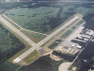
Valdosta Regional Airport is a public-use airport located three nautical miles (6 km) south of the central business district of Valdosta, a city in Lowndes County, Georgia, United States. It is owned by the Valdosta-Lowndes County Airport Authority. The Valdosta Regional airport is mostly used for general aviation, but is also served by Delta Air Lines, which offers service to Atlanta. The airport also offers free parking.

Bethel Airport is a state-owned public-use airport located three nautical miles (6 km) southwest of the central business district of Bethel, a city in the Bethel Census Area of the U.S. state of Alaska.
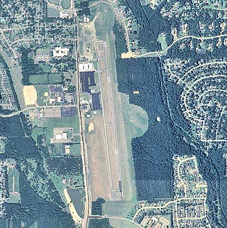
Norwood Memorial Airport is a public airport 2 mi east of Norwood, in Norfolk County, Massachusetts, United States. It is home to the offices of prominent local business people and several maintenance facilities.
Naval Air Station Whiting Field – South, also known as South Whiting Field, is located three miles (5 km) north of the central business district of Milton, in Santa Rosa County, Florida, United States. This military airport is owned by the US Navy. It is one of two airfields located at Naval Air Station Whiting Field, the other airfield being NAS Whiting Field – North.

Pompano Beach Airpark is a public airport located one mile (1.6 km) northeast of the central business district of Pompano Beach, in Broward County, Florida, United States. This airport is publicly owned by the City of Pompano Beach.

Ryan Airfield, also known as Ryan Field, is a city-owned, public-use airport located 12 miles southwest of the central business district of Tucson, a city in Pima County, Arizona, United States. It is included in the National Plan of Integrated Airport Systems for 2011–2015, which categorized it as a reliever airport. It is mostly used for general aviation but also serves a significant amount of law enforcement and military helicopter activity. Approximately 50% of Ryan's traffic is training-related.

Lake Elmo Airport is a public airport located just outside the city of Lake Elmo in Washington County, Minnesota, United States, about 12 miles east of the central business district of St. Paul. Although most airports in the United States use the same three-letter location identifier for the FAA and International Air Transport Association (IATA), this airport is assigned 21D by the FAA but has no designation from the IATA or ICAO. It is also home to a Civil Air Patrol squadron.

Enterprise Municipal Airport is a city-owned, public-use airport located three nautical miles (6 km) west of the central business district of Enterprise, a city in Coffee County, Alabama, United States. It is included in the National Plan of Integrated Airport Systems for 2011–2015, which categorized it as a general aviation facility.

Monroe County Airport is a county-owned public-use airport located three nautical miles (6 km) south of the central business district of Monroeville, in Monroe County, Alabama, United States. According to the FAA's National Plan of Integrated Airport Systems for 2009–2013, it is categorized as a general aviation facility.

Tillamook Airport is a public use airport located 3 miles (4.8 km) south of the central business district of Tillamook, a city in Tillamook County, Oregon, United States. It is owned by the Port of Tillamook Bay. According to the FAA's National Plan of Integrated Airport Systems for 2009–2013, it is categorized as a general aviation facility.

Allen Army Airfield is a public and military use airport serving Fort Greely and located three miles (5 km) south of the central business district of Delta Junction, a city in the Southeast Fairbanks Census Area of the U.S. state of Alaska. It is owned by the United States Army, which has an agreement with the City of Delta Junction for joint use of the airfield by both military and civilian aircraft.

Demopolis Regional Airport is a city-owned, public-use airport located six nautical miles southwest of the central business district of Demopolis, a city in Marengo County, Alabama, United States. It is also known as Demopolis Municipal Airport and Julian D. "Buzz" Sawyer Airport.

Stennis International Airport is a public use airport in Hancock County, Mississippi, United States. Owned by the Hancock County Port and Harbor Commission, the airport is located eight nautical miles (15 km) northwest of the central business district of Bay St. Louis, Mississippi. It is included in the National Plan of Integrated Airport Systems for 2019-2023, which categorized it as a general aviation facility.
Bardera Airport is an airport serving Bardera, a city in the southern Gedo region in Somalia.

Grenada Municipal Airport is a public use airport in Grenada County, Mississippi, United States. It is owned by the City of Grenada and located three nautical miles (6 km) north of the central business district. This airport is included in the National Plan of Integrated Airport Systems for 2011–2015, which categorized it as a general aviation facility. There is no scheduled commercial airline service.
Bruce Campbell Field is a city-owned public-use airport located two nautical miles (4 km) southeast of the central business district of Madison, a city in Madison County, Mississippi, United States. This airport is included in the National Plan of Integrated Airport Systems for 2011–2015, which categorized it as a general aviation airport.

Bowers Field is a county-owned, public-use airport in Kittitas County, Washington, United States. It is located two nautical miles (4 km) north of the central business district of Ellensburg, Washington. This airport is included in the National Plan of Integrated Airport Systems for 2011–2015, which categorized it as a general aviation facility.

Kismayo Airport, also known as Kisimayu Airport, is an international airport serving Kismayo, the capital city of the Lower Juba region in Somalia. It is located in southern Jubaland, an autonomous region in Somalia.
