Bakkafjörður

Last updated • 4 min readFrom Wikipedia, The Free Encyclopedia
Bakkafjörður
Village
Bakkafjordhur.JPG
Bakkafjörður, Sept 2008
Langanesbyggd Loc.svg
Location of the Municipality of Langanesbyggð
Iceland adm location map.svg
Red pog.svg
Bakkafjörður
Location of Bakkafjörður in Iceland
Coordinates: 66°02′N14°48′W / 66.033°N 14.800°W / 66.033; -14.800
CountryFlag of Iceland.svg  Iceland
Constituency Northeast Constituency
Region Northeastern Region
Municipality Langanesbyggð
Population
 (January 2011)
  Total72
Time zone UTC+0 (GMT)
Post Code
685
Website Official website

Bakkafjörður (Icelandic pronunciation: [ˈpahkaˌfjœrðʏr̥] ) is a small fishing village in North-East Iceland, located in a fjord with the same name.

Contents

The village has 72 inhabitants and is part of the regional service center of Langanesbyggð district in Northeastern Region.

History

Hróðgeir hvíti Hrappsson was the first to occupy Sandvík. He lived near Skeggjastaðir and Sandvík, which is now called Bakkafjörður but Sandvíkurheiði (between Bakkafjörður and Vopnafjörður), still bears the ancient name.

Hofn, built in the 1800s Hofn at Bakkafjordur.jpg
Höfn, built in the 1800s

The largest farm at Sandvík was likely Höfn. Built in the 1800s somewhere in modern day Bakkafjördur. Later on, more houses were built on Hafnartangi. Most of these original houses were demolished except for one.

Hafnartangi in the early 20th century. Hafnartangi at Bakkafjordur.jpg
Hafnartangi in the early 20th century.

Halldórsshús was built in 1900. It was owned by Halldór, who ran his shop until his death in 1920. His trading house is still stands on the tang and is often referred to as the merchant's house or Halldórshús.


In Höfn, the port facilities were poor, despite the name, but boats lay by clapping at Hafnartangi and the catch was pulled (or carried up) ashore, directly to the house. In the early 1900s, around the trade and fish receptions that had then begun to form so-called grass farms in Hafnar's land with a small stock, a few cows and sheep, but most of those who lived on them also engaged to some extent in fishing. The main grass farms include Steinholt, Lindarbrekku, Bjarg and Bergholt. Some of these farms are still standing in some form and even inhabited in some houses, though not with animals.

After Halldórs death, Jakob Gunnlaugsson's Store in Copenhagen established a branch in Bakkafjörður, as Halldór had had a main business dealings with that company.

The first telephone of the town came between Vopnafjörður and Bakkafjörður in 1916. (A rural telephone later came in 1954.) In 1933 work began on the so-called Bakkafjörður road, a road around the countryside. In 1949, a road connection was finally established between Bakkafjörður and Þórshöfn over Brekknaheiði, after many years of work. Funds were first granted for the road in 1936, but construction did not begin in full until 1943. With the road, Langanesströnd and Bakkafjörður were connected to the country's road network for the first time. A road over Sandvíkurheiði between Bakkafjörður and Vopnafjörður was built in 1955-1960.

Construction of the harbour wall Bakkafjardarhofn build.jpg
Construction of the harbour wall

Around 1945, the construction of a harbour pier on Bakkafjörður began, for the first time. Casting was done on top of the skerry rocks, which were cut just below the Hafnartang, and there a pier was created with a small wall. It was later lengthened around 1970 with the help of the Icelandic Coast Guard. A major problem at the port was the fact that the fishermen were not allowed to use the port crane to hoist the fish out of the boats. Because of this, most of the fishermen would use small crates or simply throw the fish onto a trailer.

A small airport was built not far from the village. However, it did not come with a hangar, and funding for it from the public sector was repeatedly postponed. More often than not, the locals took matters into their own hands. In 1979, the municipality bought one of the so-called emergency fund houses; it was moved east and used as a hangar. This would have been unique as the hangar was built without the involvement of the Civil Aviation Authority. This hangar was in use throughout the life of the airport. In the end the airport was closed around the early 2000s.

Sights

Church at Skeggjastadir, the oldest church in eastern Iceland Bakkafj.Kirkja.jpg
Church at Skeggjastaðir, the oldest church in eastern Iceland

Skeggjastaðakirkja is the oldest church in eastern Iceland can be visited at Skeggjastaðir, a farm on the main road close to Bakkafjörður. The wooden church which was built in 1845 seats about 100 persons, and it was renovated in its authentic style from 1961 to 1962 and reopened on 16 September 1962. [1] The pulprit and the interior were made of driftwood. The altar painting dates from 1857. The small tower with three old bells were added in 1962. [2] Legend has it that there has always been a church dedicated to Saint Thorlákur here since the Christianization of Iceland in 1000. Permission to view the church must be obtained at Skeggjastaðir, however requests are rarely turned down.

Digranes lighthouse, north of Bakkafjordur Digranes lighthouse.jpg
Digranes lighthouse, north of Bakkafjörður

Digranes lighthouse was built in 1943-1947 and is 18,4 m tall. From Digranes, the view over Bakkaflói is like no other.

Related Research Articles

<span class="mw-page-title-main">Tsing Yi</span> Island in Hong Kong

Tsing Yi, sometimes referred to as Tsing Yi Island, is an island in the urban area of Hong Kong, to the northwest of Hong Kong Island and south of Tsuen Wan. With an area of 10.69 km2 (4.13 sq mi), the island has extended drastically by reclamation along almost all its natural shore and the annexation of Nga Ying Chau (牙鷹洲) and Chau Tsai. Three major bays or harbours, Tsing Yi Lagoon, Mun Tsai Tong and Tsing Yi Bay (青衣灣) in the northeast, have been completely reclaimed for new towns.

<span class="mw-page-title-main">Rørvik</span> Town in Central Norway, Norway

Rørvik is a port town and administrative centre in the municipality of Nærøysund in Trøndelag county, Norway. It is on the eastern side of the Vikna archipelago on the island of Inner-Vikna. The 1.82-square-kilometre (450-acre) town has a population (2022) of 3,385 and a population density of 1,715 inhabitants per square kilometre (4,440/sq mi).The municipality has a population (2022) of 9,840.

<span class="mw-page-title-main">Port Isaac</span> A village in Cornwall, England

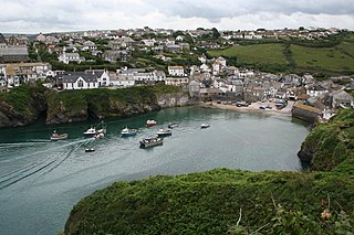
Port Isaac is a small fishing village on the Atlantic coast of north Cornwall, England, in the United Kingdom. The nearest towns are Wadebridge and Camelford, each ten miles (16 km) away. A nearby hamlet, Port Gaverne, is sometimes considered to be part of Port Isaac. The meaning of the village's Cornish name, Porthysek, is "corn port", indicating a trade in corn from the arable inland district.

<span class="mw-page-title-main">Fécamp</span> Commune in Normandy, France

Fécamp is a commune in the Seine-Maritime department in the Normandy region in north-western France.

<span class="mw-page-title-main">Sørvágur</span> Village in Faroe Islands, Kingdom of Denmark

Sørvágur is a village on the island of Vágar in the Faroe Islands.

<span class="mw-page-title-main">Kjøllefjord</span> Village in Northern Norway, Norway

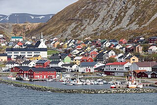
Kjøllefjord is the administrative centre of Lebesby Municipality in Troms og Finnmark county, Norway. The village is located on the northwestern part of the Nordkinn Peninsula, on the shore of a small fjord which empties into the larger Laksefjorden. The 0.45-square-kilometre (110-acre) village has a population (2017) of 945, which gives the village a population density of 2,100 inhabitants per square kilometre (5,400/sq mi) and makes it the largest village in the municipality and one of the largest fishing villages in Finnmark county.

<span class="mw-page-title-main">Styrsö</span> Place in Västergötland, Sweden

Styrsö is a small island and a locality situated in Göteborg Municipality, Västra Götaland County, Sweden. It had 1,304 inhabitants in 2010.

<span class="mw-page-title-main">Lybster</span> Human settlement in Scotland

Lybster is a village on the east coast of Caithness in northern Scotland. It was once a big herring fishing port.

<span class="mw-page-title-main">Stöðvarfjörður</span> Village in Northeast Constituency, Iceland

Stöðvarfjörður is a village in east Iceland. It sits on the Northern shore of the fjord of the same name, is part of the municipality of Fjarðabyggð and has less than 200 inhabitants.

<span class="mw-page-title-main">Höfn</span> Municipality in Eastern Region, Iceland

Höfn or Höfn í Hornafirði is an Icelandic fishing town in the southeastern part of the country. It lies near Hornafjörður fjord.

<span class="mw-page-title-main">Vopnafjörður</span> Municipality in Eastern Region, Iceland

Vopnafjörður is a village and municipality in Northeast Iceland, standing on a peninsula in the middle of a mountainous bay by the same name. The main industries of Vopnafjörður are fish processing, agriculture and tourism and other services.

<span class="mw-page-title-main">Cesenatico</span> Comune in Emilia-Romagna, Italy

Cesenatico is a port town with about 26,000 inhabitants on the Adriatic coast of Italy. It is located in the province of Forlì-Cesena in the region of Emilia-Romagna, about 30 kilometres (19 mi) south of Ravenna. Cesenatico's port canal was surveyed and drawn by Leonardo da Vinci at the request of Cesare Borgia, as part of his plans to fortify the nearby town of Cesena.

<span class="mw-page-title-main">Selá (Vopnafjörður)</span>

Selá is a river in Vopnafjörður, Iceland, and one of Iceland's most exclusive rivers for salmon angling.

<span class="mw-page-title-main">Mullion Cove</span> Village in the United Kingdom

<span class="mw-page-title-main">Vágur</span> Municipality and village in Faroe Islands, Kingdom of Denmark

Vágur meaning bay is a town and municipality on the island of Suðuroy, part of the Faroe Islands

<span class="mw-page-title-main">Icelandic cuisine</span> Cuisine of Iceland

The cuisine of Iceland has a long history. Important parts of Icelandic cuisine are lamb, dairy, and fish, the latter due to the fact that Iceland has traditionally been inhabited only near its coastline. Popular foods in Iceland include skyr, hangikjöt, kleinur, laufabrauð, and bollur. Þorramatur is a traditional buffet served at midwinter festivals called Þorrablót; it includes a selection of traditionally cured meat and fish products served with rúgbrauð and brennivín. The flavors of this traditional country food originate in its preservation methods: pickling in fermented whey or brine, drying, and smoking.

<span class="mw-page-title-main">Barcombe Mills</span> Hamlet in East Sussex, England

Barcombe Mills is a small settlement and an area of countryside including a local nature reserve near the village of Barcombe Cross in East Sussex, England. It is located in the civil parish of Barcombe in the Lewes District. It is an important area for its wildlife, natural environment and water storage. The River Ouse and Andrew's Stream, one of its tributaries and popular for fishing, flow through the area and Barcombe Reservoir is adjacent. The area includes a small hamlet and some farms, including Barcombe House, and a water treatment works.

<span class="mw-page-title-main">Portskewett</span> Village and community in Monmouthshire, Wales

Portskewett is a village and community (parish) in Monmouthshire, south east Wales. It is located four miles south west of Chepstow and one mile east of Caldicot, in an archaeologically sensitive part of the Caldicot Levels on the Welsh shore of the Severn Estuary. The Second Severn Crossing passes overhead carrying the M4 motorway. The community includes Sudbrook, Crick and Leechpool.

<span class="mw-page-title-main">Puerto Ángel</span> Town in Oaxaca, Mexico

Puerto Ángel is a small coastal town in the Mexican state of Oaxaca located in the municipality of San Pedro Pochutla. It, along with San Agustinillo and Playa Zipolite are known as the "Riviera Oaxaqueña". It is located 9 km south of city of Pochutla approximately 50 kilometers west of Huatulco and 80 kilometers east of Puerto Escondido. Despite tourism development since the 1960s, the town is still mostly a fishing village, located on a small bay surrounded by rocky hills that lead into the Sierra Madre del Sur. It was founded in the mid-19th century as a port for the region's coffee and lumber industries but since then other means of shipping these products has replaced it.

<span class="mw-page-title-main">Fishing in Cornwall</span> Economic activity

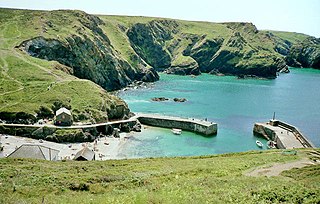
Fishing in Cornwall, England, UK, has traditionally been one of the main elements of the economy of the county. Pilchard fishing and processing was a thriving industry in Cornwall from around 1750 to around 1880, after which it went into an almost terminal decline. During the 20th century the varieties of fish taken became much more diverse and crustaceans such as crab and lobster are now significant. Much of the catch is exported to France due to the higher prices obtainable there. Though fishing has been significantly damaged by overfishing, the Southwest Handline Fishermen's Association has started to revive the fishing industry. As of 2007, stocks were improving. The Cornwall Sea Fisheries Committee is one of 12 committees responsible for managing the corresponding Sea Fisheries District. The Isles of Scilly Sea Fisheries Committee is responsible for the Scilly district.

References

  1. Gunnar Christánsson: Churches of Iceland, p. 94. Reykjavík 1988.
  2. "Skeggjastaðakirkja". Archived from the original on 2017-12-01.