
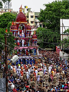
Chengalpattu, previously known as Chinglepet, is a town and the headquarters of Chengalpattu district of the state Tamil Nadu, India. The town is located near to the industrial and IT hub. It is the headquarters of the district and is 56 kilometres (35 mi) away from the state capital, Chennai on the National Highway 45. Chengalpattu Railway Station, technically known as CGL, is one of the major railway junctions of the Southern Railway and is a nationally important halt.
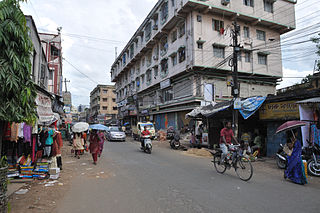
Serampore is a city of Hooghly district in the Indian state of West Bengal. It is the headquarter of the Srirampore subdivision. It is a part of the area covered by Kolkata Metropolitan Development Authority (KMDA). It is a pre-colonial city on the west bank of the Hooghly River. It was part of Danish India under the name Frederiknagore from 1755 to 1845.

Punalur is a Municipality in Kollam district of Kerala State in India. It is the headquarter of the Punalur Taluk and Punalur Revenue Division. It's situated in the eastern part of Kollam district of Kerala, on the banks of the Kallada River and foothills of the western ghats. It is about 45 kilometres (28 mi) north-east of Kollam and 68 kilometres (42 mi) north of Thiruvananthapuram.Punalur is also Known as Mini Pamba, Lap of the Western Ghat, and Gateway of Sabarimala.

Chandpur (চাঁদপুর) is a district located in Bangladesh's Chittagong Division. It was a part of Comilla District until 1984.

Calabanga, officially the Municipality of Calabanga, is a 1st class municipality in the province of Camarines Sur, Philippines. According to the 2015 census, it has a population of 83,033 people.

Naihati is a city and a municipality of North 24 Parganas district in the Indian state of West Bengal. It is a part of the area covered by Kolkata Metropolitan Development Authority (KMDA).

Zhombe is a rural communal area in Kwekwe District, Midlands Province, Zimbabwe.It is an area of mixed Shona and Northern Ndebele People.It lies along Mnyathi Border line between Midlands and Mashonaland Provinces. There are a few commercial farms within its borders and a handful of resettlement areas. Most of it is within the Zhombe Constituency. Its administrative centre is the Zhombe Joel Growth Point, and it is under the Zibagwe Rural District Council.

Chandpur is a town and a municipal board in Bijnor district in the Indian state of Uttar Pradesh, India.
Belgharia is a locality in Kamarhati Municipality of North 24 Parganas district in the Indian state of West Bengal. It is close to Kolkata and also a part of the area covered by Kolkata Metropolitan Development Authority (KMDA). Belgharia is also known for wholesale market for all types of Bags/Luggages/Purse etc. One must visit and check the Bag Market beside Belgharia Railway Station. The great Dakshineswar Kali Temple of Kolkata is in approximately three kilometers distance from Belgharia Railway Station. The Vivekananda Setu on the river of Hooghly which is one of the oldest bridge in Calcutta established for the connection between the city of Howrah and Kolkata is also at the adjacent area of Belgharia.

Panskura is a town and a municipality in Purba Medinipur district in the Indian state of West Bengal. It is situated on the banks of the Kangsabati River.

Alstonville is a town in northern New South Wales, Australia, part of the region known as the Northern Rivers. Alstonville is on the Bruxner Highway between the town of Ballina and city of Lismore. The village of Wollongbar is 4 km to the west of Alstonville. Alstonville is the service centre of the area known as the Alstonville Plateau.

Brekstad is a city in the municipality of Ørland in Trøndelag county, Norway. It is located along the Trondheimsfjord at the entrance to the Stjørnfjorden. The town is located about 5 kilometres (3.1 mi) south of the village of Uthaug and about 7 kilometres (4.3 mi) west of the villages of Austrått and Ottersbo.

Haziganj or Hajiganj is an upazila of Chandpur District in the Division of Chittagong, Bangladesh.
Raipur is an upazila in Lakshmipur District, Chittagong Division, Bangladesh. It is surrounded by the upazilas of Faridganj, Ramganj, Lakshmipur Sadar, Mehendiganj and Haimchar, and on the west by the Megna River. Raipur has 40,618 households, and covers an area of 201.32 square kilometres (77.73 sq mi).

Shapur is a village in Vanthali taluk in Junagadh district in the Indian state of Gujarat. This region is known as "Sorath", after the former Princely State of Junagadh.

Madhumalla is a village development committee in Morang District in the Koshi Zone of south-eastern Nepal. With a population of 21,482 as of the 2011 Nepal census and situated at the foothills of Raja rani mountain, Madhumalla is a village sandwiched by two rivers Mawa and Nunsari. Its neighbours are Urlabari municipality to its south, Damak municipality to its east and south, and Illam district to its north. This village is at a distance of 7.3 km north of Urlabari

Sheoraphuli is a neighbourhood of Hooghly district in the Indian state of West Bengal. It is on West side of river hooghly. It is a part of the area covered by Kolkata Metropolitan Development Authority (KMDA).
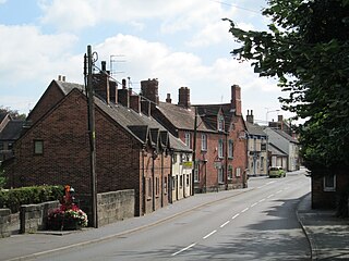
Tean is a large village in Staffordshire, England. It is around 15 kilometres (9.3 mi) south-east of Stoke-on-Trent. The River Tean runs through the village, heading east towards Uttoxeter. Population details for the 2011 census can be found under Checkley.
Agarpara is a locality in Panihati Municipality of North 24 Parganas district in the Indian state of West Bengal. It is close to Kolkata and also a part of the area covered by Kolkata Metropolitan Development Authority (KMDA).
Jhantipahari is a census town in the Chhatna CD block in the Bankura Sadar subdivision of the Bankura district in the state of West Bengal, India.
