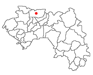
Timbo is a town and sub-prefecture in the Mamou Prefecture in the Mamou Region of Guinea. It is located in the Fouta Djallon highlands of Guinea, lying north east of Mamou, in a part of the country mostly occupied by the Fula people. It is also known for its vernacular architecture, for the local mountains and for local chimpanzees.

The Faranah Region is located in east-central Guinea. It is bordered by the countries of Sierra Leone and Mali and the Guinean regions of Kankan, Mamou, Nzérékoré, and Labé.

The Labé Region is located in north-central Guinea. It is bordered by the countries of Senegal and Mali and the Guinean regions of Faranah, Kindia, Mamou, and Boké.
Nionsomoridou is a town and sub-prefecture in the Beyla Prefecture in the Nzérékoré Region of south-eastern Guinea.
Dogomet is a town and sub-prefecture in the Dabola Prefecture in the Faranah Region of Guinea. As of 2014 it had a population of 29,040 people.
Mafara is a town and sub-prefecture in the Dalaba Prefecture in the Mamou Region of western Guinea.
Mitty, Guinea is a town and sub-prefecture in the Dalaba Prefecture in the Mamou Region of western Guinea.
Sandéniah is a town and sub-prefecture in the Faranah Prefecture in the Faranah Region of Guinea. As of 2014 it had a population of 17,454 people.
Guendembou is a town and sub-prefecture in the Guéckédou Prefecture in the Nzérékoré Region of south-western Guinea.
Molota is a town and sub-prefecture in the Kindia Prefecture in the Kindia Region of western Guinea.
Souguéta is a town and sub-prefecture in the Kindia Prefecture in the Kindia Region of western Guinea.
Fermessadou-Pombo is a town and sub-prefecture in the Kissidougou Prefecture in the Faranah Region of Guinea. As of 2014 it had a population of 19,489 people.
Manfran is a town and sub-prefecture in the Kissidougou Prefecture in the Faranah Region of Guinea. As of 2014 it had a population of 14,385 people.
Pilimini is a town and sub-prefecture in the Koubia Prefecture in the Labé Region of northern Guinea.
Salambandé is a town and sub-prefecture in the Mali Prefecture in the Labé Region of northern Guinea.
Ouré-Kaba is a town and sub-prefecture in the Mamou Prefecture in the Mamou Region of Guinea.
Gongore is a town and sub-prefecture in the Pita Prefecture in the Mamou Region of northern-central Guinea.
Kiniébakoura is a town and sub-prefecture in the Siguiri Prefecture in the Kankan Region of northern Guinea.
Thionthian is a town and sub-prefecture in the Télimélé Prefecture in the Kindia Region of western-central Guinea.
Bowé is a town and sub-prefecture in the Yomou Prefecture in the Nzérékoré Region of south-eastern Guinea.