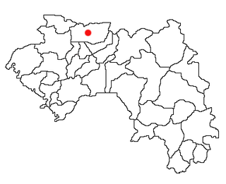
Lélouma is a prefecture located in the Labé Region of Guinea. The capital is Lélouma. The prefecture covers an area of 2,140 km.² In census of 2014, it had population of 163,000.

The Labé Region is located in north-central Guinea. It is bordered by the countries of Senegal and Mali and the Guinean regions of Faranah, Kindia, Mamou, and Boké.
Huerta de Valdecarábanos is a municipality located in the province of Toledo, Castile-La Mancha, Spain. According to the 2006 census (INE), the municipality has a population of 1784 inhabitants.
Canal de Berdún is a municipality located in the province of Huesca, Aragon, Spain. According to the 2004 census (INE), the municipality has a population of 401 inhabitants.
Langa de Duero is a municipality located in the province of Soria, Castile and León, Spain. According to the 2004 census (INE), the municipality has a population of 867 inhabitants.

Constantina is a Spanish municipality located in the province of Seville, in Andalusia. It has a population of 6757 (2006) and an area of 483 km². It is 87 km from the provincial capital, Seville.
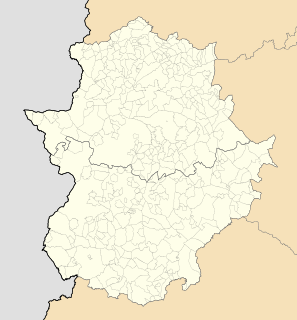
Campanario is a Spanish municipality in the province of Badajoz, Extremadura. It has a population of 5,470 (2007) and an area of 284 km².

Koba is a town and sub-prefecture in the Dalaba Prefecture in the Mamou Region of western Guinea.
Khorira is a town and sub-prefecture in the Dubréka Prefecture in the Kindia Region of western Guinea.
Sikhourou is a town and sub-prefecture in the Forécariah Prefecture in the Kindia Region of western Guinea.
Ouéndé-Kénéma is a town and sub-prefecture in the Guéckédou Prefecture in the Nzérékoré Region of south-western Guinea.
Kolenté is a town and sub-prefecture in the Kindia Prefecture in the Kindia Region of western Guinea.
Bardou is a town and sub-prefecture in the Kissidougou Prefecture in the Faranah Region of Guinea. As of 2014 it had a population of 9,767 people.
Baro is a town and sub-prefecture in the Kouroussa Prefecture, Kankan Region, of eastern-central Guinea. As of 2014 it had a population of 15,578 people.
Tounkarata is a sub-prefecture in the Lola Prefecture in the Nzérékoré Region of south-eastern Guinea.
Korbé is a town and sub-prefecture in the Lélouma Prefecture in the Labé Region of northern-central Guinea.
Manda, Guinea is a town and sub-prefecture in the Lélouma Prefecture in the Labé Region of northern-central Guinea.
Fello-Koundoua is a town and sub-prefecture in the Tougué Prefecture in the Labé Region of northern-central Guinea.
Bourouwal is a town and sub-prefecture in the Télimélé Prefecture in the Kindia Region of western-central Guinea.
Péla is a town and sub-prefecture in the Yomou Prefecture in the Nzérékoré Region of south-eastern Guinea.