Balcreuchan Port

Last updated

Balcreuchan Port
Ballantrae, Scotland
GB grid reference NX908878
Balcreuchan Port and Cave. Ballantrae. South Ayrshire.jpg
Balcreuchan Port and Cave
South Ayrshire UK location map.svg
Red pog.svg
Balcreuchan Port
Coordinates 55°08′44″N4°59′04″W / 55.145565°N 4.9845220°W / 55.145565; -4.9845220

Balcreuchan Port or Balcruachan Port (NX0908878) [1] is a bay and raised beach site in the parish of Colmonell, close to Bennane Head and Port Vad (NX091870) in South Ayrshire, Scotland. It is well known for its cave (NX099876) with its links to the legend of Sawney Bean and also for the unusual geology that is found in the bay. It was a minor fishing harbour up until the mid to late 19th century.

Contents

Infrastructure

The first edition of the OS Map shows that a channel in the bay that had been cleared of stones to permit the safe landing of boats. [2] The channel remnants are currently still visible at low tide (Datum 2020). No other artificial features directly related to the port itself have been observed.

History

The site of the cleared channel with Ailsa Craig and the Isle of Arran in the background Arran and Ailsa Craig from Balcreuchan Port, Ballantrae, South Ayrshire.jpg
The site of the cleared channel with Ailsa Craig and the Isle of Arran in the background

The name 'Port' is indicative of its use, and Balcreuchan is Gaelic, with the first 'Bal' part meaning a farmstead. A farm of that name is shown slightly inland from the port. [3] The 'creuchan' may be from crìochan, 'borders' or 'bounds' as in Na Crìochan, 'the Borders', and Na Garbh Chrìochan - 'the rough bounds/Highlands'. The Balcreuchan Burn runs to the coast just east of the port up to the area of Knockormal Hill and the 'Lochton' place names suggest a more substantial flow at one time. [4]

This remote area is well known for smuggling in the past, and Balcreuchan Port had a reputation for such activities in association with the existence of the cave. [5]

Alexander Peden was a famous Ayrshire Covenanter minister who had been captured at a conventicle near remote Knockdow not far from Balcreuchan Port and sentenced to a jail term on the Bass Rock. He later spent some time in Northern Ireland and upon his return to Scotland in the 1680s he may have landed at Balcreuchan Bay as the secluded bay he landed at is recorded as having been between Ballantrae and Lendalfoot, with a shingle beach. [6]

The port

It is described as a "Small Creek or indentation of the sea Coast where there is a Small flat beach. Composed of Shingle & boulders." [7] The Scotlands Places site records that boats were pulled up onto the beach and secured here in the summer months. [7] Port Vad nearby has a similar record but it was more exposed to wind and wave action. [7] The nearby enclosure suggests that the bay may have been inhabited during the summer months by fishermen. The transport of stock and materials such as lime for the fields are not on record for the bay.

The cave

Two cave sites are linked with the legend of Sawney Bean, Balcreuchan being often quoted; [8] the other is Bennane Cave a short distance down the coast towards Ballantrae. In some cases the name Bennane Cave is given; however the description and/or photographs match Balcreuchan Cave. [9] [10] [11]

In the 1970s Balcreuchan Cave became associated with Sawney Bean, and this led to a safe path down to the site being created, and the cave was soon after recorded on Ordnance Survey maps. [12]

It is on record in 1912 that tramps and gypsies used Balcreuchan Cave for overnight stays. [13]

The cave itself is damp, and about seventy feet deep and is accessed by a gully through the rocks that is flooded when the tide is high. It is said that the cave once ran for a mile or more into the headland. [13]

The enclosure

The location of the walled enclosure beneath the headland. Site of enclosure, Balcreuchan Port, South Ayrshire.jpg
The location of the walled enclosure beneath the headland.
Fishermen's sheds at the Carleton Fishery Old fishermen's huts, Carleton Port, Lendalfoot, South Ayrshire.jpg
Fishermen's sheds at the Carleton Fishery

The First OS map shows a walled enclosure of about one third of an acre (one eighth of a hectare) located on the raised beach area on the east side of the bay, running up to and sheltered by a headland and well above the spring high tide mark on the raised beach. [2] The enclosure has four or so divisions and sub-divisions. Small structures are shown within the area that may be fishermen's huts. [2] A track ran from the entrance to the enclosure along the raised beach area and then up the slope to reach the top of the cliffs, having passed over the cave. [2] A hay ree for storing animal feed is marked on the OS map where the nearby Balcreuchan Burn reaches the sea.

After the First OS map the enclosure and track are progressively less detailed, with just an enclosure wall indicated and then the site not marked at all. [14] This may have been a summer dwelling for fishermen with huts or sheds much like the surviving example at the old Carleton Fishery just up the coast, where a similar clearing of a channel on the beach of stones is shown on the OS map. [4]

The site today

The aspen clone on the headland Aspen (Populus tremula) Clone, Balcreuchan Port, South Ayrshire.jpg
The aspen clone on the headland

The fallen walls of the enclosure are not visible amongst the dense undergrowth, although there are many stones throughout the area. The track from the enclosure and up the cliff slope is not discernable. As stated, the area of channel cleared of stones in the bay can still be made out at low tide. The cave access has been hindered by the fall of a large boulder that must be climbed over to gain access to the cave itself. There are a lot of graffiti on the walls of the cave.

The former Kyle and Carrick District Council opened a safe access path in 1978 and publicised the links with Sawney Bean, however the port now has no maintained path and access requires appropriate sturdy hill walking footwear and great caution. [15]

Botany

The headland above the old enclosure is the location of a rare tree for this area of Scotland, the aspen (Populus tremula). A clone of the aspen is grows along the summit ridge. Part of the bay lies in a Site of Special Scientific Interest (SSSI).

Geology

View from Balcreuchan Cave entrance down to the beach Balcreuchan Cave beach access, Balcreuchan Port, South Ayrshire.jpg
View from Balcreuchan Cave entrance down to the beach
A basalt boulder near the cave Basalt boulder, Balcreuchan Port, South Ayrshire.jpg
A basalt boulder near the cave

The rocks here are a section of ancient oceanic crust around 500 million years old. This rare rock formation has formed because a fragment of oceanic crust has been emplaced onto continental crust. In the bay, rocks of the upper mantle progress to igneous rocks of the oceanic crust and finally on to the sedimentary rocks of the ancient sea floor. The rarely exposed rocks of the upper mantle are visible. These are serpentinite rocks that once lay over 5 kilometres beneath the seabed. A major fault separates the serpentinites of the ancient upper mantle and the igneous rocks of the crust, cutting in front of Balcreuchan Cave which is itself formed in basalt. Towards the foreshore a prominent igneous dyke cuts through the softer serpentinite. [8]

Related Research Articles

<span class="mw-page-title-main">Girvan</span> Burgh in South Ayrshire, Scotland

Girvan is a burgh and harbour town in Carrick, South Ayrshire, Scotland. Girvan is situated on the east coast of the Firth of Clyde, with a population of about 6,450. It lies 21 miles (34 km) south of Ayr, and 29 miles (47 km) north of Stranraer, the main ferry port from Scotland to Northern Ireland.

<span class="mw-page-title-main">Sawney Bean</span> Legendary 16th century Scottish cannibal

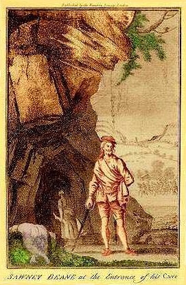
Alexander "Sawney" Bean is a legendary figure, said to have been the head of a 45-member clan in Scotland in the 16th century that murdered and cannibalised over 1,000 people in 25 years. According to the legend, Bean and his clan members were eventually caught by a search party sent by King James VI, and were executed for their heinous crimes.

<span class="mw-page-title-main">Kynance Cove</span> Inlet on the coast of Cornwall, England

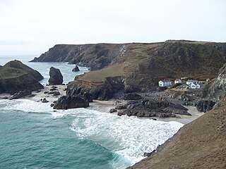
Kynance Cove is a cove on the eastern side of Mount's Bay, Cornwall, England. It is situated on the Lizard peninsula approximately two miles (3 km) north of Lizard Point. The cove became popular in the early Victorian era, with many distinguished visitors including Queen Victoria and Prince Albert and the poets Alfred Tennyson and Algernon Swinburne. The BBC has described Kynance Cove as "one of the most beautiful stretches of coastline in the South West". The South West Coast Path, which follows the coast of south west England from Somerset to Dorset passes by on the cliffs overlooking the cove.

<span class="mw-page-title-main">Ballantrae</span> Human settlement in Scotland

Ballantrae is a community in Carrick, South Ayrshire, Scotland. The name probably comes from the Scottish Gaelic Baile na Tràgha, meaning the 'town by the beach'. Ballantrae has a primary school. The beach consists of shingle and sand and offers views of Ailsa Craig, the Isle of Arran and Kintyre.

<span class="mw-page-title-main">Basement (geology)</span> Metamorphic or igneous rocks below a sedimentary platform or cover

In geology, basement and crystalline basement are crystalline rocks lying above the mantle and beneath all other rocks and sediments. They are sometimes exposed at the surface, but often they are buried under miles of rock and sediment. The basement rocks lie below a sedimentary platform or cover, or more generally any rock below sedimentary rocks or sedimentary basins that are metamorphic or igneous in origin. In the same way, the sediments or sedimentary rocks on top of the basement can be called a "cover" or "sedimentary cover".

<span class="mw-page-title-main">Franciscan Complex</span> Late Mesozoic terrane of heterogeneous rocks in the California Coast Ranges

The Franciscan Complex or Franciscan Assemblage is a geologic term for a late Mesozoic terrane of heterogeneous rocks found throughout the California Coast Ranges, and particularly on the San Francisco Peninsula. It was named by geologist Andrew Lawson, who also named the San Andreas fault that defines the western extent of the assemblage.

<span class="mw-page-title-main">Lizard complex</span>

The Lizard complex, Cornwall is generally accepted to represent a preserved example of an exposed ophiolite complex in the United Kingdom. The rocks found in The Lizard area are analogous to those found in such famous areas as the Troodos Mountains, Cyprus and the Semail Ophiolite, Oman.

<span class="mw-page-title-main">Horseshoe Bay, Isle of Wight</span> Bay on the south-east coast of the Isle of Wight near Culver Down

Horseshoe Bay is a small bay on the south-east coast of the Isle of Wight, England. It lies at the east end of the headland of Culver Down. It faces south-east towards the English Channel and its shoreline is approximately 100 yards (90 m) in length. It should not be confused with a similarly named Horseshoe Bay about 8 miles (13 km) southwest at Bonchurch.

<span class="mw-page-title-main">Igneous rock</span> Rock formed through the cooling and solidification of magma or lava

Igneous rock, or magmatic rock, is one of the three main rock types, the others being sedimentary and metamorphic. Igneous rocks are formed through the cooling and solidification of magma or lava.

<span class="mw-page-title-main">Bennane Head</span> Tapering piece of land formed of hard rock in South Ayrshire, Scotland

Bennane Head is a tapering piece of land formed of hard rock, projecting into the Firth of Clyde, in South Ayrshire, west of Scotland. At the northern end of Ballantrae Bay, 17 kilometres (11 mi) southwest of Girvan. A 200-metre-deep (660 ft) cave in the cliff under the headland is said to be the place where the cannibal Sawney Bean and his family lived in the 16th century.

<span class="mw-page-title-main">Peden's Cave (Auchinbay)</span>

Peden's Cave is at least partly artificial and is set into a craggy outcrop of red sandstone rocks overlooking the River Lugar just below the farm of Auchinbay in East Ayrshire, Scotland, close to the town of Ochiltree. Traditionally it is said that this cave was used as a hiding place for Covenanters, including the famous Covenanter minister Alexander Peden in the 17th century, mainly during the so-called 'Killing Times' of the 1680s.

<span class="mw-page-title-main">Wallace's Cave, Auchinleck</span>

Wallace's Cave in the Lugar Gorge at Auchinleck in the Parish of Auchinleck is an 18th-century grotto contemporary with Dr Johnson's Summerhouse, also located on the Auchinleck Estate. It shows superior workmanship in its construction, possibly being the enlargement of a pre-existing cave. The cave or grotto lies downstream of the confluence of the Dippol Burn with the River Lugar and is reached via a once well formed path, however access is now hazardous due to the condition of the cliff edge path and the vertical drop into the River Lugar.

<span class="mw-page-title-main">Ballantrae Windmill</span> Windmill in South Ayrshire, Scotland

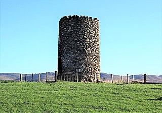
The Ballantrae Windmill, on Mill Hill was a late 17th or early 18th century vaulted tower windmill, the ruins of which are located above the old raised beach cliffs on the outskirts of the village of Ballantrae in South Ayrshire, Scotland. Built around 1696 it was disused by 1799 and is a Category A Listed Building due to its important place in early industrial development.

<span class="mw-page-title-main">Dun Mountain-Maitai Terrane</span> Geological feature in New Zealand

The Dun Mountain-Maitai Terrane comprises the Dun Mountain Ophiolite Belt, Maitai Group and Patuki Mélange. The Dun Mountain Ophiolite is an ophiolite of Permian age located in New Zealand's South Island. Prehistorically this ophiolite was quarried by Māori for both metasomatized argillite and pounamu (jade) which was used in the production of tools and jewellery.

<span class="mw-page-title-main">Lendalfoot</span> Human settlement in Scotland

Lendalfoot is a small village located on Carleton Bay, parish of Colmonell in the old district of Carrick, now South Ayrshire, about six miles south of Girvan, Scotland. This is mainly a farming district, lacking in woodland, with a low population density. The village sits astride the A77 that runs north to Girvan and south to Cairnryan and Stranraer. Carleton Hill rises to 520 feet or 158 metres from the road and is the site near its summit of earth banks, an ancient fort.

<span class="mw-page-title-main">Minishant</span> Human settlement in Scotland

Minishant is a village bordering the A77 in the old county of Carrick, South Ayrshire, Scotland. It is located in Maybole Parish, 3+12 miles from Maybole and standing close to the River Doon. The village was originally named Culroy after the Culroy Burn that runs through it.

<span class="mw-page-title-main">Meigle, North Ayrshire</span> Human settlement in Scotland

Meigle or Meagle is a hamlet on the Meigle Burn in North Ayrshire, Parish of Largs, Scotland. The settlement lies close to the road to Greenock and is named after the bay where the Skelmorlie Burn flows into the Firth of Clyde. Meigle once stood on the old toll road from Largs to Greenock. It lies 41 m (135 ft) above sea level. Skelmorlie Castle and glen lie nearby. The Meigle Burn has its confluence with the Skelmorlie Burns to the east of Skelmorlie Bridge. The modern spelling 'Meigle' will be used for consistency. There is also a village called Meigle in Perth & Kinross.

<span class="mw-page-title-main">Pancake Rocks and Blowholes</span> Coastal rock formation in New Zealand

The Pancake Rocks and Blowholes are a coastal rock formation at Punakaiki on the West Coast of the South Island of New Zealand. They are a popular visitor attraction.

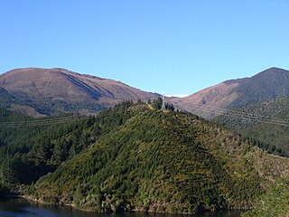
The Ballantrae Complex is an assemblage of rocks in southwest Scotland considered to be an ophiolite, that is a section of the earth's oceanic crust and upper mantle obducted onto continental crust. The complex is bounded by the coast of the Firth of Clyde to the west and the Stinchar Valley Fault, a constituent element of the Southern Uplands Fault to the south. The emplacement of this highly faulted assemblage of both intrusive and extrusive igneous rocks and metamorphic rocks took place within the Grampian phase of the Caledonian orogeny.

References

Notes

  1. Graham, Angus (1984). Old Ayrshire Harbours. AA&NHS. p. 168.
  2. 1 2 3 4 Ayrshire, Sheet LXI, Surveyed: 1855, Published:1858
  3. Girvan. Surveyed 1846 to 1856, Published in 1863
  4. 1 2 Ayrshire, Sheet LXI, Surveyed in 1855, Published in 1858
  5. Czerkawska, Catherine (1975). Fisher Folk of Carrick. The Molendinar Press. p. 38. ISBN   0-904002-09-8.
  6. Watson, Robert (2006). Peden: Prophet of the Covenant. Shoving Leopard. p. 260. ISBN   1-905565-04-6.
  7. 1 2 3 "Balcreuchan Port". Scotlands Places.
  8. 1 2 Scotland - the home of Geology
  9. Sawney Bea. Scotland's Most Famous Cannibal
  10. The Legend of Sawney Bean
  11. Undiscovered Scotland - Sawney Bean
  12. Ayrshire History
  13. 1 2 Love, Dane (2009). Legendary Ayrshire. Custom:Folklore:Tradition. Carn Publishing. p. 32. ISBN   978-0-9518128-6-0.
  14. Ayrshire LX.SE & LXI.SW, Surveyed in 1894, Published in 1897
  15. Knowledge Base - Balcreuchan

Sources