
The Matterhorn is a mountain of the Alps, straddling the main watershed and border between Italy and Switzerland. It is a large, near-symmetric pyramidal peak in the extended Monte Rosa area of the Pennine Alps, whose summit is 4,478 metres (14,692 ft) above sea level, making it one of the highest summits in the Alps and Europe. The four steep faces, rising above the surrounding glaciers, face the four compass points and are split by the Hörnli, Furggen, Leone/Lion, and Zmutt ridges. The mountain overlooks the Swiss town of Zermatt, in the canton of Valais, to the northeast; and the Italian town of Breuil-Cervinia in the Aosta Valley to the south. Just east of the Matterhorn is Theodul Pass, the main passage between the two valleys on its north and south sides, which has been a trade route since the Roman Era.

Makalu is the fifth-highest mountain on Earth, with a summit at an elevation of 8,485 metres (27,838 ft) AMSL. It is located in the Mahalangur Himalayas 19 km (12 mi) southeast of Mount Everest, on the China–Nepal border. One of the eight-thousanders, Makalu is an isolated peak shaped like a four-sided pyramid.

Manaslu is the eighth-highest mountain in the world at 8,163 metres (26,781 ft) above sea level. It is in the Mansiri Himal, part of the Nepalese Himalayas, in west-central Nepal. Manaslu means "mountain of the spirit" and the word is derived from the Sanskrit word manasa, meaning "intellect" or "soul". Manaslu was first climbed on May 9, 1956, by Toshio Imanishi and Gyalzen Norbu, members of a Japanese expedition. It is said that, given the many unsuccessful attempts by the British to climb Everest before Nepali Tenzing Norgay and New Zealander Edmund Hillary, "just as the British consider Everest their mountain, Manaslu has always been a Japanese mountain".

Wildspitze is the highest mountain in the Ötztal Alps and in North Tyrol, as well as the second highest mountain in Austria after the Großglockner and in terms of prominence is the fourth summit of the Alps and the fifteenth of Europe.

The Großglockner, or just Glockner, is, at 3,798 metres above the Adriatic (12,461 ft), the highest mountain in Austria and highest mountain in the Alps east of the Brenner Pass. It is part of the larger Glockner Group of the Hohe Tauern range, situated along the main ridge of the Central Eastern Alps and the Alpine divide. The Pasterze, Austria's most extended glacier, lies on the Grossglockner's eastern slope.
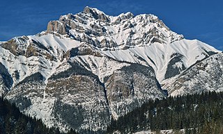
Cascade Mountain is a mountain located in the Bow River Valley of Banff National Park, adjacent to the town of Banff. The mountain was named in 1858 by James Hector after the waterfall or cascade on the southern flanks of the peak. The mountain has also been called Stoney Chief, which is related to the name of the smaller neighbouring mountain Stoney Squaw, which is still in use. Cascade is the highest mountain adjacent to the townsite.

Toubkal, also Jbel Toubkal or Jebel Toubkal, is a mountain in southwestern Morocco, located in the Toubkal National Park. At 4,167 m (13,671 ft), it is the highest peak in Morocco, the Atlas Mountains, North Africa and the Arab world. Located 63 km (39 mi) south of the city of Marrakesh, and visible from it, Toubkal is an ultra prominent peak, the highest for over 2,000 km (1,200 mi). Toubkal is ranked 27th by topographic isolation.

Hunter Mountain is in the towns of Hunter and Lexington, just south of the village of Hunter, in Greene County, New York, United States. At approximately 4,040 feet (1,231 m) in elevation, it is the highest peak in the county and the second-highest peak in the Catskill Mountains.
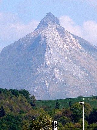
Txindoki or Larrunarri is an iconic mountain located in the region of Goierri, Gipuzkoa, in the Basque Autonomous Community of Spain. Originally Larrunarri or Ñañarri, the mount took on the popularized name Txindoki by extension after some shepherd huts nearby. It is sometimes referred to as the Basque Matterhorn too, because of its pyramidal shape.

The Dom is a mountain of the Pennine Alps, located between Randa and Saas-Fee in the canton of Valais in Switzerland. With a height of 4,546 m (14,915 ft), it is the seventh highest summit in the Alps, overall. Based on prominence, it can be regarded as the third highest mountain in the Alps, and the second highest in Switzerland, after Monte Rosa. The Dom is the main summit of the Mischabel group, which is the highest massif lying entirely in Switzerland.

Slide Mountain is the highest peak in the Catskill Mountains of the U.S. state of New York. It is located in the town of Shandaken in Ulster County. While the 4,180-foot (1,270 m) contour line on topographic maps is generally accepted as its height, the exact elevation of the summit has never been officially determined by the U.S. National Geodetic Survey or its predecessors, and many informal surveys suggest the mountain may actually top 4,200 feet (1,280 m) above sea level. Geographically, it is the highest natural point within the New York Metropolitan Area.

Halcott Mountain is one of the Catskill Mountains of the U.S. state of New York. It is mostly located in Greene County, with some of its lower slopes in Delaware and Ulster counties. Its exact summit elevation has not been officially determined, but the highest contour line on the mountain is 3,520 feet (1,070 m). It is one of the peaks on the divide between the Delaware and Hudson watersheds.

Graham Mountain is the seventh highest of the Catskill High Peaks and the highest privately owned mountain in the range. It is located in the town of Hardenburgh, New York, United States.

Brace Mountain is the peak of a ridge in the southern Taconic Mountains, near the tripoint of the U.S. states of New York, Connecticut and Massachusetts. Its 2,311-foot (704 m) main summit is located in New York; it is the highest point in that state's Dutchess County.
The Aralar Range is a mountain range in the Basque Mountains of the Southern Basque Country. The part of the range lying in Gipuzkoa was established as a conservation area called Aralar Natural Park in 1994. In addition to its natural features, scenery, recreational use and habitation, the range is home to a number of Basque mythology milestones and legends.

The Snake Den Ridge Trail is an American hiking trail in the Great Smoky Mountains National Park of Cocke County, Tennessee. Winding its way up the backbone-like crest of Snake Den Ridge, the trail connects the Cosby Campground to the Appalachian Trail and provides the quickest access to the high peaks of the Eastern Smokies. The trail passes through three forest types— a mixed deciduous forest at its lower elevations, a substantial stand of heath bald on the more narrow sections of the ridge crest, and an old growth northern-style coniferous forest at its higher elevations.

The Maddron Bald Trail is an American hiking trail in the Great Smoky Mountains National Park of Cocke County, Tennessee. Rising from the outskirts of the Cosby community, the trail ascends Maddron Bald, a 5,212-foot (1,589 m) mountain crowned by one of the park's most substantial heath balds. The trail also provides access to Albright Grove, a patch of old growth hardwood forest that contains some of the oldest and tallest trees in the Smokies. The Maddron Bald Trail's terminus— at its junction with the Snake Den Ridge Trail— is just 0.7 miles (1.1 km) from the Appalachian Trail.

Ganboa is a summit on the Gipuzkoan side of the Aralar Range, the mount having long been held as the highest in the range, while nowadays it trails second to Irumugarrieta. The peak, crowned with a mountaineer postbox, is surrounded by grasslands, secondary peaks and limestone karst terrain, where deep fissures are not rare to be seen.

The Sonneck is a 2,260-metre-high (7,410 ft) mountain in the Kaisergebirge range of the Northern Limestone Alps in Austria. On its broad peak stands a solid summit cross, the panorama is comprehensive and there are particularly good views of the Ellmauer Halt, the highest mountain in the range, the Treffauer and Lake Hinterstein.
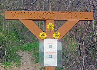
The Wilkinson Memorial Trail is a public footpath in the Hudson Highlands region of the U.S. state of New York. It generally follows the Dutchess–Putnam county line along the latter's northwest corner, from the banks of the Hudson River near Breakneck Ridge to North Highland, just south of the county line in Philipstown. At 9.5 miles (15.3 km) in length it is the longest trail in the Hudson Highlands State Park system; although parts of the trail are on other public and private parcels in the area.

