The administrative divisions of Nepal are subnational administrative units of Nepal. The first level of country subdivision of Nepal are the provinces. Each province is further subdivided into districts, each district into municipalities and rural municipalities, and each of those municipalities into wards. Before 2015, instead of provinces, Nepal was divided into developmental regions and administrative zones.

Solududhkunda (earlier:Dudhkunda) is the only municipality of Solukhumbu District. Located in Koshi Province of Nepal. The town of Salleri, which is located within the municipality is the headquarter of Solukhumbu District It was formed in 2014 by merging four VDCs: Salleri, Garma, Loding Tamakhani and Beni and was divided into 9 wards. Total area of the municipality had 254.3 square kilometres (98.2 sq mi) and population of municipality had 20,399 individuals living in 5,368 households.

A village development committee in Nepal was the lower administrative part of its Ministry of Federal Affairs and Local Development. Each district had several VDCs, similar to municipalities but with greater public-government interaction and administration. There were 3,157 village development committees in Nepal. Each village development committee was further divided into several wards depending on the population of the district, the average being nine wards.
Jogimara was a village development committee in Dhading District in the Bagmati Zone of central Nepal. At the time of the 1991 Nepal census it had a population of 5080 and had 927 houses in it. On March 10, 2017, the Government of Nepal restructured local level bodies into 753 new local level structures. Mahadevsthan, Benighat, Dhusha and Jogimara VDCs were merged to form Benighat Rorang. हुग्दिखोला Majhimtar Jamireghat is the main market of Jogimara VDC. Here lies a calcium ore.
Maidi is a village in Dhading District in the Bagmati Zone of central Nepal. At the time of the 1991 Nepal census it had a population of 8496 and had 1627 houses in it.
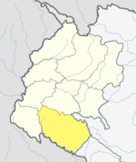
Chuha is a town in Lamki Chuha Municipality in Kailali District in Sudurpashchim Province of western Nepal. The formerly Village development committee was merged along with Baliya VDC to form the new municipality on 18 May 2014. At the time of the 1991 Nepal census it had a population of 10,145 living in 1,497 individual households.
Melung is a Rural municipality located within the Dolakha District of the Bagmati Province of Nepal. The municipality spans 86.54 square kilometres (33.41 sq mi) of area, with a total population of 20,210 according to a 2011 Nepal census.
Byans is a rural area of the Byans Rural Municipality in the Darchula District and Sudurpashchim Province of Nepal. At the time of the 1991 Nepal census, the population was 723; by the 2011 Nepal census, it had dropped to 556.
Tapoban is a village in Darchula District in the Mahakali Zone of western Nepal. At the time of the 1991 Nepal census it had a population of 1841 people living in 305 individual households.
Gonaha is a village in Rupandehi District in Lumbini Province of southern Nepal. At the time of the 1991 Nepal census it had a population of 10,838.
Bhedihari is a village in the Parsa District of the Narayani Zone, southern Nepal. At the time of the 2011 Nepal census it had a population of 5,772 people living in 846 individual households. There were 2,977 males and 2,795 females at the time of census.

Markhu is a village in the Indrasarowar Rural Municipality of Makwanpur District in the Bagmati Province of Nepal. At the time of the 1991 Nepal census it had a population of 3137 people living in 581 individual households.
Titirkhi is a village in Kapilvastu District, in the Lumbini Province of southern Nepal. At the time of the 1991 Nepal census it had a population of 3241 people living in 491 individual households.
Udayapur is a village in Kapilvastu District of the Lumbini Province of southern Nepal. At the time of the 1991 Nepal census it had a population of 2814 people living in 478 individual households.
Vidhyanagar is a village in Kapilvastu District in the Lumbini Zone of southern Nepal. At the time of the 1991 Nepal census it had a population of 3315 people living in 538 individual households.
Hardauna is a village in the sub-metropolitan municipality of Maharajganj in the Kapilvastu District of the Lumbini Province. The village is in a terai region in southern Nepal. It is on the Banganga, a river which arises on the southern slopes of the Sivalik Hills and flows across the Terai, reaching into Uttar Pradesh state in India.
Kajarhawa is a village in Kapilvastu District in the Lumbini Province of southern Nepal. At the time of the 2001 Nepal census it had a population of 3438 people living in 571 individual households.
Lamki Chuha is a municipality in Kailali District in Sudurpashchim Province of Nepal established on 18 May 2014 by merging Baliya and Chuha, two existing village development committees. Later in May, 2014 it was formed by merging all the ward of Pratappur Village development committee. Lamki Chuha lies 72 kilometres (45 mi) east of Dhangadhi and 590 km (370 mi) west of the capital, Kathmandu. It is surrounded by Bardagoriya Rural Municipality and Joshipur Rural Municipality in the West, Bardiya District in the East, Mohanyal Rural Municipality in the North and Janaki Rural Municipality in the South. Its Municipal office is located at Lamki chuha 2 Bhalka, Kailali.
A gaunpalika is an administrative division in Nepal. The Ministry of Federal Affairs and Local Development dissolved the existing village development committees and announced the establishment of this new local body. It is a sub-unit of a district. There are currently 481 rural municipalities.