Dhangadhi is a sub-metropolitan city and the district headquarters of Kailali District in Sudurpashchim Province of Nepal. It shares a border with India in the south, Godawari and Gauriganga Municipality in the North, Kailari Rural Municipality in the east and Kanchanpur District in the west. Dhangadhi is a sub-metropolis divided into 19 wards. It has an area of 271.74 Sq. KM. It is one of the major cities of Far - West Province of Nepal along with Mahendranagar. The city is connected with the Mahakali Highway, about 750 kilometers west of Kathmandu.

Bardiya District, one of the seventy-seven Districts of Nepal, is part of Lumbini Province of Nepal. The district, with Gulariya as its headquarters, covers an area of 2,025 km2 (782 sq mi) and according to the 2001 census the population was 382,649 in 2011 it has 426,576.
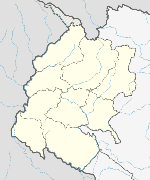
Kailali District, a part of Sudurpashchim Province in Terai plain, is one of the 77 districts of Nepal. The district, with Dhangadhi as its district headquarters, covers an area of 3,235 square kilometres (1,249 sq mi) and has a population of 911,155 and, .
Kanchanpur District, a part of Sudurpashchim Province in the Terai plain, is one of seventy-seven districts of Nepal. The district, with Bhimdatta as its district headquarters, covers an area of 1,610 square kilometres (620 sq mi) and had a population of 134,868 in 2001 and 171,304 in 2011. It is located in south-western of Nepal. It is bordered by Kailali district in the east, Dadeldhura district in the north and with India in the south and west.
Bhajani is a Municipality in Kailali District in the Sudurpashchim Province of Nepal. At the time of the 2011 Nepal census it had a population of 52,128. It is surrounded by Tikapur Municipality and Joshipur Rural Municipality in the East, Kailari Rural Municipality in the West, Ghodaghodi Municipality in the North and Tikunia, Uttar Pradesh in the South. It is divided into 9 wards.
Gauriganga Municipality is a municipality in Kailali District in the Sudurpashchim Province. At the time of the 2011 Nepal census it had a population of 55,314 living in 5,293 individual households. It is Surrounded by Ghodaghodi Municipality in the west, Godawari Municipality in the east, Mohanyal and Chure Rural Municipality in the north and Dhangadhi Sub Metropolitan City and Kailari Rural Municipality in the south.
Godawari Municipality formerly known as Attariya Municipality is a municipality located in the Kailali District of Nepal.
Joshipur is Rural Municipality in Kailali District of Sudurpashchim Province established by merging Bauniya and Joshipur two existing village development committees. Joshipur lies 75 km east of Dhangadhi and 61 3 km west of the capital, Kathmandu. It is surrounded by Lamki Chuha Municipality, Tikapur Municipality and Janaki Rural Municipality in the East, Ghodaghodi Municipality and Bhajani Municipality in the West, Bardagoriya Rural Municipality in the North and Bhajani Municipality in the South.
Mohanyal is a former village development committee that is now a rural municipality in Kailali District in Sudurpashchim Province of western Nepal. At the time of the 1991 Nepal census it had a population of 3917 living in 614 individual households.

Tikapur is a Municipality in Kailali District in Sudurpashchim Province of Nepal that was established in January 1997. Tikapur Municipality was further expanded on 10 March 2017 through merger with the two former Village development committees Narayanpur and Dansinhapur. It lies on the bank of Karnali River.
Triveni is a rural municipality in Salyan District in the Karnali Province of western-central Nepal. At the time of the 1991 Nepal census it had a population of 3789 people living in 710 individual households.
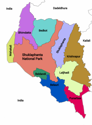
Punarwas is a Municipality in Kanchanpur District in Sudurpashchim Province of south-western Nepal. The new Municipality was established on 18 May 2014 by merging the existing 3 Village Development Committees i.e. Parasan, Tribhuwanbasti and Kalika. At the time of the 2011 Nepal census, it had a population of 43,996 people living in Punarwas.

Sanphebagar is a municipality in Achham District in Sudurpashchim Province of Nepal that was established on 18 May 2014 by merging the two former Village development committees Baijinath, Jalapadevi, Siddheswar, Mastamandau, Nawathana, Bhagyeshwar, Ridikot, Chandika. It lies on the bank of Budhi Ganga River. At the time of the 2011 Nepal census it had a population of 33,788 people living in 6,693 individual households. Sanphebagar is about 25 km north of the district headquarters of Mangalsen.
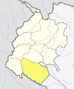
Lamki Chuha is a municipality in Kailali District in Sudurpashchim Province of Nepal established on 18 May 2014 by merging Baliya and Chuha, two existing village development committees. Later in May, 2014 it was formed by merging all the ward of Pratappur Village development committee. Lamki Chuha lies 72 kilometres (45 mi) east of Dhangadhi and 590 km (370 mi) west of the capital, Kathmandu. It is surrounded by Bardagoriya Rural Municipality and Joshipur Rural Municipality in the West, Bardiya District in the East, Mohanyal Rural Municipality in the North and Janaki Rural Municipality in the South. Its Municipal office is located at Lamki chuha 2 Bhalka, Kailali.
Jayaprithvi is a municipality and the district headquarter of Bajhang District in Sudurpashchim Province of Nepal that was established on 18 May 2014 by merging the two former Village development committees Rithapata, Chainpur, Hemantabada, Luyanta and Subeda. It lies on the bank of Seti River.
Bardagoriya is a rural municipality in Kailali District of Nepal. Bardagoriya Rural Municipality lies 65 km east of Dhangadhi and 605 km west of the capital, Kathmandu. It is surrounded by Ghodaghodi Municipality to the west, Lamki Chuha Municipality to the east, Joshipur Rural Municipality to the south and Mohanyal to the north. Bauniya Bazar is its largest market.
Ghodaghodi Municipality is a Municipality in Kailali District of Sudurpashchim Province. Ghodaghodi lies 58 km east of Dhangadhi and 613 km west of the capital, Kathmandu. It is surrounded by Mohanyal in the north, Bhajani Municipality in the south, Bardagoriya Rural Municipality in the east and Gauriganga Municipality in the west. It is divided into 12 wards. It was established by merging Darakh, Sadepani, Ramsikhar Jhala and Pahalmanpur 4 existing village development committees.

Badimalika Municipality is a newly formed municipality in Bajura District in the Sudurpashchim Province of Nepal. It was formed in March, 2017 as decided by the Cabinet in line with the Constitution of Nepal 2015
Rajpur Rural Municipality is a municipal unit in Dang District, Lumbini Province in western Nepal. It was formed by a combination of the erstwhile Bela and Rajpur Village Development Committees. The center of the Rural Municipality is located at Gangdi.
Janaki is a rural municipality in Kailali District located in Sudurpashchim Province of Nepal.