The Churchill River is a major river in Alberta, Saskatchewan and Manitoba, Canada. From the head of the Churchill Lake it is 1,609 kilometres (1,000 mi) long. It was named after John Churchill, 1st Duke of Marlborough and governor of the Hudson's Bay Company from 1685 to 1691. The Cree name for the river is Missinipi, meaning "big waters". The Denesuline name for the river is des nëdhë́, meaning "Great River".

The Sturgeon River is a 260-kilometre-long (160 mi) river in central Alberta. It is a major tributary of the North Saskatchewan River. The river crosses Sturgeon County, which was named for this river. For much of its length, the Sturgeon is the northwestern-most major river in the Hudson Bay drainage basin, as the river runs close to and parallel to the Arctic Divide.
Deschambault Lake is a freshwater lake in the north-eastern region of the Canadian province of Saskatchewan. The identically-named community of Deschambault Lake resides on its shore. There are also four Indian reserves on the lake — Kimosom Pwatinahk 203, Mistik Reserve, Pisiwiminiwatim 207, and Muskwaminiwatim 225 — and a provincial recreation site.
The Peter Ballantyne Cree Nation is a Woodland Cree First Nation in northern Saskatchewan consisting of eight communities: Denare Beach, Deschambault Lake, Kinoosao, Pelican Narrows, Prince Albert (Kiskaciwan), Sandy Bay, Southend and Sturgeon Landing. The administrative centre of Peter Ballantyne Cree Nation is Pelican Narrows and the centralized government of the First Nation is located in Prince Albert, Saskatchewan.
Little Bear Lake is a lake in the boreal forest ecozone in the Canadian province of Saskatchewan. The lake is in a hilly plateau called Cub Hills and the landforms, such as the lakes and streams, of the Cub Hills were formed over 10,000 years ago during the last ice age. Little Bear Lake is accessed from the Hanson Lake Road, which runs along the eastern side of the lake, and by a small airport called Little Bear Lake Airport.

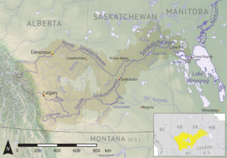
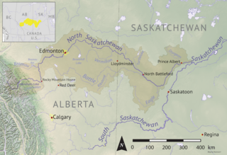
Torch River is a river in the Canadian province of Saskatchewan. The river's source is the dam at Candle Lake, near Candle Lake Provincial Park, and it travels east through boreal forest and muskeg en route to its mouth in the Saskatchewan River Delta. Torch River Provincial Forest, a conservation area, is located along the course of the river, near where White Fox River flows into Torch River. Torch River is a significant tributary of the Saskatchewan River and it is part of the Hudson Bay drainage basin.

Sturgeon River is a river in the Hudson Bay drainage basin in the central part of the Canadian province of Saskatchewan. It flows from its source in the Waskesiu Hills in Prince Albert National Park to the North Saskatchewan River, just west of the city of Prince Albert.

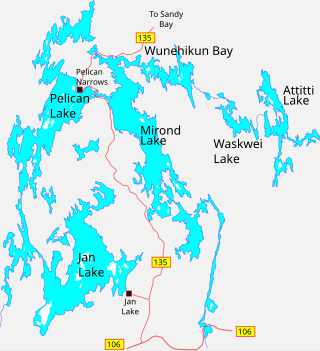
Mirond Lake is a lake in the Canadian province of Saskatchewan. It lies in low-relief forested terrain of the Canadian Shield. The climate is sub-arctic.

Moose Jaw River is a river in the Canadian province of Saskatchewan. It is located in the southern part of the province in a region called the Prairie Pothole Region of North America, which extends throughout three Canadian provinces and five U.S. states. It is also within Palliser's Triangle and the Great Plains ecoregion.

Mossy River is a river in the Canadian province of Saskatchewan. The river's source is east of Little Bear Lake and north-east of Narrow Hills Provincial Park in a hilly plateau called Cub Hills. The river travels through hills, boreal forest, and muskeg for about 100 kilometres en route to its mouth in the Saskatchewan River Delta. Highway 920 is the only road to access the mainstem of the river and there are no communities nor settlements along the course of the river.
Summit Lake is a lake in the east-central part of the Canadian province of Saskatchewan in Narrow Hills Provincial Park. It is situated in a glacier-formed valley in the Cub Hills and the boreal forest ecozone of Canada. It is located north of Lost Echo Lake and is accessed from Highway 913. There are no communities or settlements on the lake.
Lower Fishing Lake is a lake in the east-central part of the Canadian province of Saskatchewan in Narrow Hills Provincial Park. It is situated in the Cub Hills and the boreal forest ecozone of Canada. The lake is accessed from Highway 920, which connects to Hanson Lake Road and Highway 120. The Fishing Lakes Fire of 1977 burned much of the region upstream and around the lake and now the area is now dominated by jack pine, which is a tree species that is well adapted fire burned forests.
Hanson Lake is a lake in the east-central part of the Canadian province of Saskatchewan in the boreal forest ecozone of Canada. The lake is irregularly shaped with many bays, islands, and channels as it was formed by glaciers during the last ice age. It is fed by multiple rivers and creeks from surrounding hills, smaller lakes, and muskeg. Hanson Lake's outflow is through a short river at the eastern end of the lake as it flows into the Sturgeon-Weir River, a tributary of the Saskatchewan River.
The Cub Hills are a hilly plateau located south-east of the geographical centre of the Canadian province of Saskatchewan. The hills are in the boreal forest ecozone of Canada and the landforms of the hills were shaped more than 10,000 years ago during last ice age. Throughout the Cub Hills, there are dozens of lakes and rivers and several parks. The Cubs Hills are 150 km (93 mi) north-east of Prince Albert and are in the Northern Saskatchewan Administration District and Census Division #18. Several highways criss-cross the plateau to provide access to the various parks and other amenities.

Shell River, formerly Shell Brook, is a river in the north-central region of the Canadian province of Saskatchewan. The river begins at Big Shell Lake and travels in an easterly direction and flows into the Sturgeon River north of the city of Prince Albert. The upper reaches of its watershed are as far west as the Thickwood Hills.
Waskesiu Upland is a hilly plateau in the central region of the Canadian province of Saskatchewan. Waskesiu means red deer or elk in the Cree language. The plateau is just south-west of the geographical centre of the province and consists of two main ranges — the Waskesiu Hills to the south and the Thunder Hills to the north. The Thunder Hills cover an area of about 225,000 acres. Several notable rivers begin from the upland with ones headed south flowing into the North Saskatchewan River and ones headed north flowing into the Churchill River. Much of the plateau is carpeted in boreal forests and most of the Waskesiu Hills range is within Prince Albert National Park. Besides the national park, there are several provincial recreation sites in and around the upland. The northern part of the upland is part of the Northern Saskatchewan Administration District and is sparsely populated.

Pelican Lake is a lake in the Northern Administration District of the Canadian Province of Saskatchewan. The lake is situated in Canada's boreal forest. While there are several lakes and small rivers that flow into Pelican Lake, there are two main inflows. At the lake's southern end, a channel flows in from the west from Deschambault Lake. North-east of that, another channel flows in from the east from Jan Lake. Its outflow is through Opawikusehikan Narrows, near Pelican Narrows, into Mirond Lake. Pelican lake is in the Sturgeon-Weir River drainage basin. The Sturgeon-Weir River is a tributary of the Saskatchewan River.
Big Sandy Lake is a lake in the Canadian province of Saskatchewan. The lake is north-east of Narrow Hills Provincial Park at the eastern base of the Cub Hills in the Northern Administration District. It is situated in the Mid-Boreal Uplands Ecoregion in a boreal forest of pine, birch, aspen, and spruce.
Jayjay Lake is a teardrop-shaped lake in the Canadian province of Saskatchewan. It is in the Northern Saskatchewan Administration District and access is from Highway 165. The lake is situated at the north-eastern slopes of the Cub Hills in the Mid-Boreal Uplands Ecoregion. It is surrounded by muskeg in a boreal forest of pine, birch, aspen, and spruce.


