
Ballynahinch or Ballinahinch is a village in County Galway in the west of Ireland. It is situated close to Recess, on the road from Recess to Roundstone. It also lies on the route of the former railway line from Galway city to Clifden. The name comes from the Irish Baile na hInse meaning settlement of the island.

The Twelve Bens or Twelve Pins, also called the Benna Beola, is a mountain range of mostly sharp-peaked quartzite summits and ridges in the Connemara National Park in County Galway, in the west of Ireland. The widest definition of the range includes the Garraun Complex to the north as well as several isolated peaks to the west, and is designated a 16,163-hectare (39,940-acre) Special Area of Conservation.

Garraun at 598 metres (1,962 ft), is the 224th–highest peak in Ireland on the Arderin scale, however, while it is just short of the elevation threshold of 600-metres for other classifications, it does have the prominence to be a Marilyn. Garraun lies on an isolated massif near the mouth of Killary Harbour at the far north sector of the Twelve Bens/Garraun Complex Special Area of Conservation in the Connemara National Park in Galway. The southern slopes are a scenic backdrop to Kylemore Abbey and Kylemore Lough.

Lough Arrow is a freshwater lake in the northwest of Ireland. This large, scenic lake covers an area of 12.47 square kilometres (4.8 sq mi) and lies mostly in County Sligo with a smaller part in County Roscommon. It is a popular trout fishing lake.

Templehouse Lough is a freshwater lake in the northwest of Ireland. It is located in south County Sligo and forms part of the course of the Owenmore River.

Garadice Lough (Irish: Loch Guth Ard Deas, also known as Garadice Lake or Lough Garadice, is a freshwater lake in County Leitrim, Ireland. It is located in the south of the county and now forms part of the Shannon–Erne Waterway.

Lough Beagh, also known as Lough Veagh, is a freshwater lake in the northwest of Ireland. It is located in north County Donegal and is part of Glenveagh National Park.
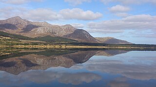
Lough Inagh is a freshwater lake in the Inagh Valley, in Connemara, Galway, in the west of Ireland.

Derryclare Lough is a freshwater lake at the entrance of the Inagh Valley, in Connemara, Galway, in the west of Ireland.

Lough Fee is a freshwater lake in the west of Ireland. It is located in the Connemara area of County Galway.

Kylemore Lough is a freshwater lake in the west of Ireland. It is located in the Connemara area of County Galway.

Rinn Lough, also known as Lough Rynn, is a freshwater lake in the northwest of Ireland. It is located in south County Leitrim.

Inchiquin Lough is a freshwater lake in the Mid-West Region of Ireland. It is located in The Burren of County Clare.
Cavetown Lough is a freshwater lake in the west of Ireland. It is located in County Roscommon in the catchment of the upper River Shannon.

The R341 road is a regional road in Ireland. It is a loop road from the N59 road in County Galway. South of the R342, the road is part of the Wild Atlantic Way.

Ballycuirke Lough, also known as Ballyquirke Lough, is a freshwater lake in the west of Ireland. It is part of the Lough Corrib catchment in County Galway.

Ballynahinch Castle is a former Irish country house and estate, built on the site of a former castle, which is now a luxury hotel set in a private estate in the Connemara region of County Galway, Ireland. The castle lies on the edge of Ballynahinch Lake and Ballynahinch River, and is directly overlooked by Benlettery 557 metres (1,827 ft), one of the Twelve Bens mountain range.

Derryclare is a mountain at the southern edge of Twelve Bens mountain range in Connemara National Park in County Galway, Ireland. At 677 metres (2,221 ft), it is the 119th–highest peak in Ireland on the Arderin list, and the 145th–highest peak on the Vandeleur-Lynam list. It is the 5th tallest of the core Twelve Bens. The Derryclare Lough on its southern slopes is a scenic location in Connemara, while Derryclare Wood, on its eastern slopes, contains a Statutory Nature Reserve (SRN).

Benglenisky at 516 metres (1,693 ft), is the 368th–highest peak in Ireland on the Arderin scale. Benglenisky is the second most southern peak, after neighbouring Benlettery, of the Twelve Bens mountain range in the Connemara National Park in Galway, Ireland, and is the lowest of the core Twelve Bens.
Ballynahinch is a barony in west County Galway, Ireland. It sits on the Atlantic coast to the west. The village of Ballynahinch is named after the barony.

